Characterized by evolving large-scale patterns and a variety of conditions across North Carolina, from wet to dry and smoky to stormy, 2023 was an interesting and impactful year in our local weather and climate.
As part of our annual wrap-up, this post summarizes our 2023 Year in Review webinar. The recording is available on YouTube, and our presentation slides are also available for download.
The Year, By the Numbers
The final statistics from the National Centers for Environmental Information (NCEI) note a statewide average temperature of 60.7°F, which left 2023 tied for our 7th-warmest year on record since 1895.
In that sense, 2023 was nothing new; each of the past nine years in North Carolina has been warmer than the recent 30-year average, including six of our state’s top ten warmest years on record.
That high ranking may come as a surprise given the cooler start to summer. However, those cool conditions in May and June were the exception, not the rule, in 2023.
The other ten months saw above-average temperatures statewide, with the warmest weather relative to normal in our climatological coolest months: January, February, and December. It’s no wonder, then, that most of the state outside of the Mountains finished the year with no measurable snowfall.
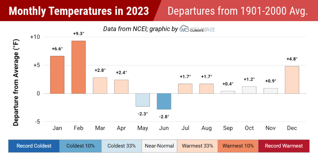
Locally, the long-term observing locations in Raleigh, Wilson, and Laurinburg all recorded their warmest years on record in 2023, while it was tied for the 2nd-warmest year in Charlotte and tied for the 3rd warmest in Asheville.
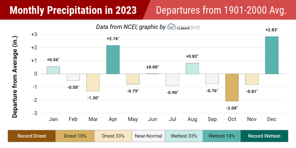
Last year’s statewide average precipitation of 48.56 inches was 2.21 inches below the 30-year average, and it was our 61st-driest year out of the past 129 years, according to NCEI.
Throughout 2023, we largely bounced back and forth between wet and dry conditions, but our 16th-driest fall on record pushed many areas into a precipitation deficit that they’d finish the year with.
Elizabeth City was 9.48 inches below normal in its 8th-driest year on record, while Highlands – a site that recorded more than 100 inches in each of the previous five years – had only 70.03 inches last year and was 18.25 inches below normal.
Thanks to wetter weather earlier in the year and in December, much of the Piedmont and southern Coastal Plain finished the year with near-normal precipitation. For instance, Wilmington was 1.23 inches below normal while Greensboro was 1.87 inches above normal.
Our Seasonal Progression
January and February felt more like spring than winter, with temperatures even reaching the 80s before the end of the season. March offered more of the same, which put flowers in bloom early before forcing them to weather a few sub-freezing nights later in the month.
That warmth was in part due to the La Niña pattern, in place for the third consecutive winter. Fortunately, we avoided the same prolonged sort of drought during these back-to-back-to-back La Niñas that we saw between 1999 and 2001. And by the end of 2023, that Pacific-based pattern would take on a very different look.
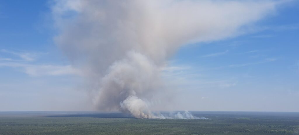
We did have a bit of springtime dryness in eastern North Carolina that led to a few wildfires, including the 32,000-acre Great Lakes Fire at the Croatan National Forest in April. However, late-month rainfall tamped down those dry areas and continued a string of wet weekends to begin the year.
May brought unseasonably cool conditions thanks to a series of upper-level low pressure systems to our north. In June, a similar pattern helped us avoid the summer heat, but also put us in the path of wildfire smoke from Canada and created some hazardous air quality.
The heat finally hit home in July and August, including triple-digit temperatures on August 15. That month ended with heavy rainfall along the coast from Tropical Storm Idalia.
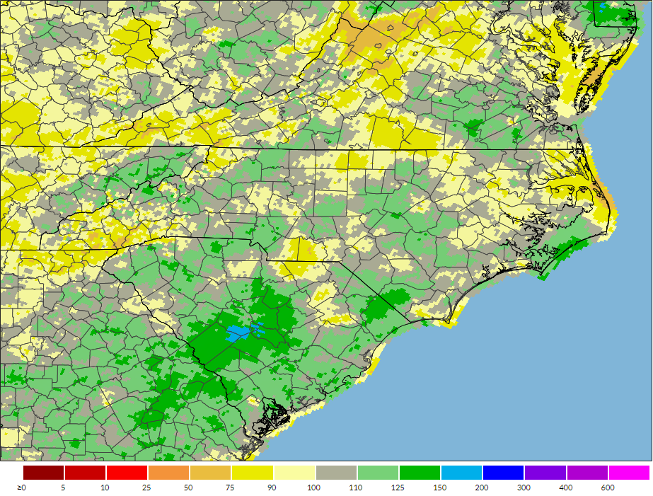
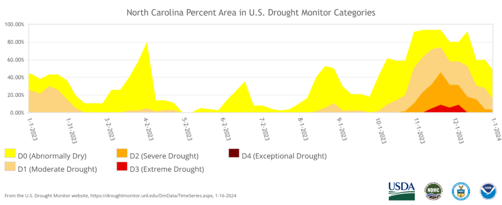
Our other tropical visitor last year, Tropical Storm Ophelia, moved through in late September, but it was followed by the abrupt emergence of a dry pattern across the state. From mid-October through mid-November, some areas saw no measurable rainfall, and drought rapidly expanded, with Extreme Drought (D3) returning to North Carolina for the first time since the spring of 2017.
By early December, the emerging El Niño finally began to impact our weather, with three weather systems during the month that each brought heavy rain to parts of the state. That proved to be a sign of things to come, as January has started with a similarly wet and active weather pattern.
Weather Hazards in 2023
Some years become defined by one or two major events, as with Hurricane Florence in 2018 or the contrasting combination of flooding from Hurricane Matthew alongside a western drought in 2016.
However, 2023 was a sum-of-its-parts sort of year, in that there were multiple events and a variety of hazards across the state.
We did have two tropical systems affect North Carolina, but we may have gotten off easy considering the overall activity in the Atlantic, with 20 tropical storms in total. Most of those stayed out at sea, and only three – Idalia, Ophelia, and Harold, which made landfall in south Texas – had direct impacts on the continental United States.
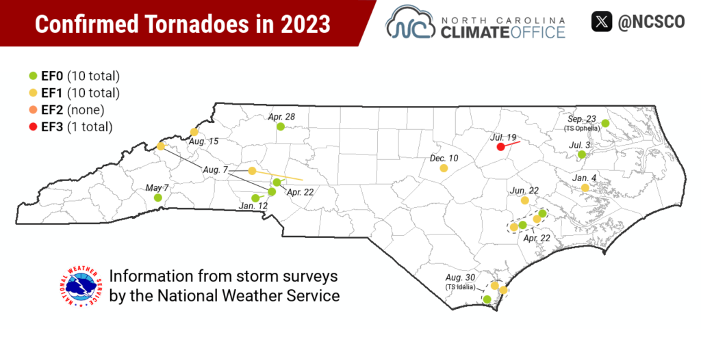
Our two tropical storms, along with severe weather events throughout the year, spawned 21 total tornadoes in 2023, which is the most in a year since 2020. The strongest of those was the July EF3 in Nash and Edgecombe counties.
It was a notable year for the off-season activity, with two tornadoes in January and another in December. There were also three rare tornadoes in the Mountains, including the first ever recorded in Mitchell County and the first in Avery County since 1965.
When it rained, it often poured in 2023, which led to localized flooding, and not just from our tropical systems. Late April saw flooding along the Neuse River in Johnston County. Late June saw floods in the Foothills and Charlotte area. And mid-July brought flooding in Alexander and Caldwell counties.
Tropical Storm Idalia caused significant flooding in the city of Whiteville, while Ophelia’s rain and storm surge flooded coastal towns including New Bern, Washington, and Greenville.
The drought that followed carried its own impacts, including low lake levels, voluntary or mandatory water restrictions in some areas, and an active fall fire season, with multiple large fires in the Mountains throughout November.
Preliminary data from the North Carolina Forest Service shows a total of 5,491 wildfires last year burning 76,063 acres on state and private lands, although that total also includes fires on federal lands – such as the Great Lakes Fire – on which they assisted.
While the final numbers may change slightly, it was still an active year compared to the recent 10-year averages for number of fires (4,232) and acreage burned (19,963). In fact, 2023 will have the most acreage burned by wildfires in North Carolina since 2016.
The Year in Perspective
With a number of often complementary and strangely symmetrical contrasts, our weather in 2023 may best be described as yin and yang – a reference to the Chinese philosophy of “inseparable and contradictory opposites.”
Take the large-scale patterns at play: La Niña to start, and El Niño by the end.
Or how our cool seasons were warm, while our warm season started cool.
Initially, it seemed to rain every weekend, but by the fall, there was barely any rain at all.
And even during the fall, we began with tropical torrents, followed immediately by an emerging drought.
We also see it in our drought progression throughout the year, starting in the east, then fading over the summer before ending up confined to western North Carolina.
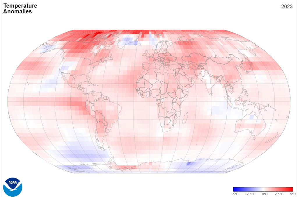
Of course, that doesn’t mean 2023 was an enigma unique to our state. In a broader context, it was the 5th-warmest year on record in the US and the warmest on record globally. The emerging El Niño explains part of that warmth, but climate change remains a key driver as well, and we can see its fingerprints all over our weather last year.
For one, there was the lack of snowfall, continuing a recent trend. Charlotte has seen its 30-year average snowfall totals more than cut in half since the late 1980s.
That’s a consequence of warming temperatures in our cooler seasons, which was particularly pronounced last year. Those unseasonably warm days with temperatures reaching the 80s in late February and early November were once unheard of, but have recently become more common. And even though it took a while to warm up this summer, once the hot temperatures arrived, they stuck around – at all hours of the day.
Warmer and more spring-like weather patterns at those times of year are also increasing the frequency of wintertime severe weather, such as our trio of January and December tornadoes. In the past ten years, we’ve had 31 wintertime tornadoes in North Carolina. That’s more than double the historical average of 12.8 per decade between 1950 and 2013.
Across the US, there were a record 28 billion-dollar weather disasters in 2023, which is even more impressive since only two of those were tropical systems. Instead, it was flooding, drought, severe weather, and wildfires all taking their toll across parts of the country. And the billion dollar disasters often don’t capture the other impacts of climate change – like the toll that extreme heat takes on human lives and health.
Our contrasting precipitation patterns, including the quick changes from wet to dry, are also an expected impact of climate change as a warming and moistening atmosphere becomes like a larger sponge: able to release more water in a single squeeze, but with longer and drier spells between events, similar to our fall flash drought.
So whether you remember it for the storms, the drought, or the snow we missed out on, our weather in 2023 tells us a lot about what’s going on with the climate, both globally and locally, and what we can expect in the future.