Dry weather continued and drought expanded in November, while temperatures ranged from wintry to warm throughout the month. We also close the book on a dry fall and an active hurricane season.
Drought Goes to the Extreme
With only one decent rain event all month in most areas, November was quite dry in North Carolina. Preliminary data from the National Centers for Environmental Information (NCEI) shows a statewide average precipitation of 2.10 inches and our 39th-driest November dating back 1895.
The first three weeks of the month saw little to no rain statewide, and on top of our dry October, much of the state had gone more than a month without significant rainfall. Hickory went 64 days in a row with less than a quarter-inch of rain observed, which was the longest such streak on record at that site, surpassing a 63-day run in the winter of 1980-81.
Just before Thanksgiving, the rain finally returned as a frontal system moved through, bringing an inch of rain or more across most of the state and up to 3 inches locally in Washington County.
That was followed by one more rain event along the coast during the last weekend of the month that pushed those areas closer to their normal November precipitation. Wilmington actually finished November 0.57 inches above normal, and Hatteras was just 0.20 inches below normal.
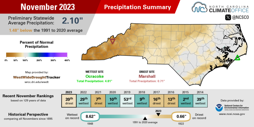
Farther inland, that one event didn’t deliver a months’ worth of rain, so November was a bit drier than normal. Piedmont locales such as Raleigh (1.49 inches) and Greensboro (1.63 inches) had a little less than half of their normal monthly precipitation. Charlotte fared a bit better with 2.49 inches in total, or just 0.82 inches short of its normal rainfall.
Other western sites were decidedly drier, and some finished the month with less than an inch of rain in total. Asheville had only 0.93 inches in its 20th-driest November on record, and Marshall tallied only 0.71 inches and its 11th-driest November since 1898.
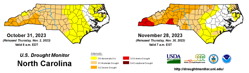
Amid that ongoing dryness, Severe Drought (D2) emerged across the western half of the state in November and Extreme Drought (D3) returned to North Carolina on the US Drought Monitor for the first time since March 2017.
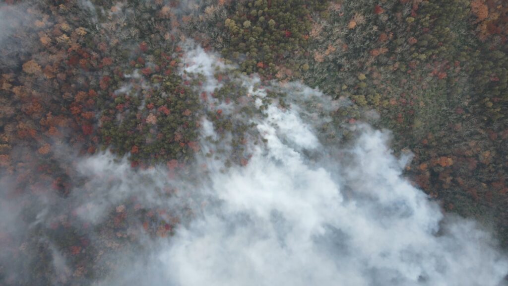
The impacts of that drought included mandatory water restrictions in areas such as Highlands and Union County, and a number of large wildfires in the Mountains, including the Collett Ridge fire in Cherokee County that burned 5,505 acres; the Poplar Drive fire in Henderson County that burned 434 acres; and the Sauratown Mountain fire that burned 805 acres and warranted evacuations from a campsite as it rapidly spread down the mountainside.
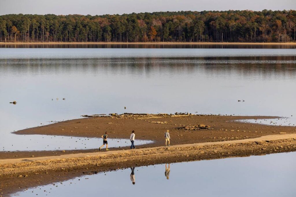
The late-month rain did help with fire containment efforts, and it briefly surged streamflows back to normal levels across the eastern Piedmont and Coastal Plain. But most reservoirs saw only a temporary boost in inflows and remain a few feet below their targets, while those drier western areas continue to see water flowing at just a trickle in creeks and waterfalls.
Mixed Temperatures in the Month
Several unseasonably warm days, balanced by some nippy nights, left our average temperatures near normal for the month. NCEI reports a preliminary statewide average temperature of 50.3°F, which is our 50th-warmest November out of the past 129 years, and on par with the recent 30-year average.
Early in the month, we tried to fit all four seasons into a single week. After the first widespread freeze of the fall on November 2, our temperatures began a steady climb into the 80s, eventually reaching almost summer-like levels on November 9.
Charlotte topped out at 83°F, which was its first November day that warm since 2006, while Asheville’s high of 82°F was its warmest ever recorded in November at the airport observing station.
That was followed by more seasonable weather through mid-month, including one day on November 21 when the state was sharply divided by a warm front, leaving western sites in the 50s while temperatures along the coast hit the low 70s.
The month ended with the coolest weather of the season so far, as morning lows on November 29 dipped into the 10s across the Mountains and northern Piedmont. Those were our coolest readings in almost a year, since the pre-Christmas cold air blast last December.
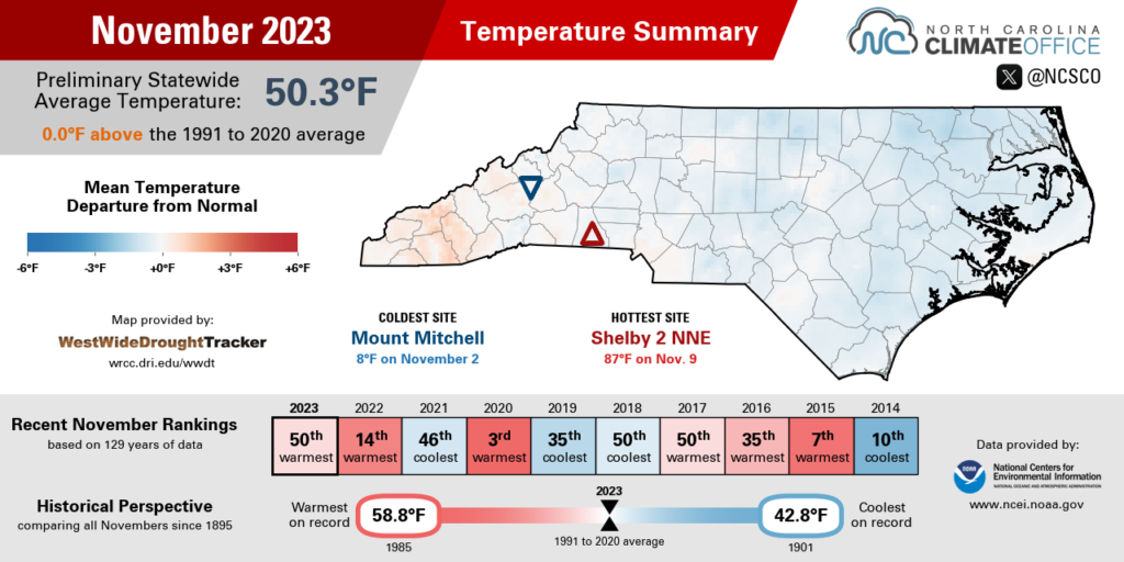
Even coastal sites saw their temperatures drop below freezing in late November. Elizabeth City reached 21°F, Morehead City bottomed out at 22°F, and Hatteras hit 31°F, which was its earliest sub-freezing fall night since November 19, 2014.
Along with temperatures touching both extremes last month, our humidity levels spanned a wide range, which was both good news and bad news for firefighters in the Mountains.
On November 3, fires ignited in Henderson and Jackson counties as relative humidity values dropped as low as 5% in Highlands and 6% on Wayah Bald Mountain – the lowest humidity reported by that ECONet station since February 26, 2022.
The following weekend behind a cold frontal passage, humidity levels stayed above 90% for more than two days, including 59 consecutive hours with 100% relative humidity at our Wayah Bald station. The Forest Service credited the persistent fog – even moreso than the half-inch of rain that weekend – with saturating vegetation and preventing further spread of the Collett Ridge wildfire.
Although November may be known for its crisp fall weather, we thankfully got a break from that last month, and just in time as drought-fueled wildfires were spreading across the landscape.
A Dry Fall, and Active Tropics
November 30 marked the end of two seasons that had big impacts in North Carolina this year. Both the climatological fall and the Atlantic hurricane season came to a close, and each had some notable stats in 2023.
The three-month fall from September 1 to November 30 ranked as our 15th-driest on record, with a statewide average precipitation 5.72 inches below normal. It was also out 40th-warmest fall on record, with an average temperature 0.14°F above normal, according to the preliminary data from NCEI.
The Atlantic hurricane season officially ended with 20 tropical storms, which was tied for the fourth-most ever recorded in the basin. Only the 2005, 2020, and 2021 seasons had more named storms.
Two of those storms reached North Carolina: Tropical Storm Idalia, which skirted the southern coast in late August, and Tropical Storm Ophelia, which came ashore on Emerald Isle in late September and brought locally heavy rainfall to the central and northern Coastal Plain.
Of course, we might have expected even more local activity than that with so many storms developing, but as we saw last year, the late-season storms generally stayed over the open ocean. In fact, Ophelia was the final storm of the season to impact the United States.
It’s no coincidence the lack of tropical systems on our doorstep in October occurred in tandem with the emergence of drought across the state, since we count on tropical rainfall for a portion of our summer and fall precipitation.
Without that rain, the deficits grew quickly, including an 8.58-inch seasonal departure from normal in Wilmington, which averages more than 8 inches of rain in September alone but saw just 3.21 inches during that month this year.
The initial predictions for this hurricane season were clouded with uncertainty due to the potential impacts of El Niño, which often shuts down storm activity due to stronger upper-level winds and increased wind shear.
But as we mentioned in our winter outlook, this El Niño’s atmospheric impacts never quite reached North America – or the Atlantic – during the fall. And with record high ocean temperatures this year, that allowed storms to flourish, all while persistent high pressure and dry weather gripped our region.
Our two rain events in the past two weeks give hope that the pattern may finally be changing to one more typical of an El Niño pattern, and the current December outlook favors above-normal precipitation this month.
Given how dry our fall was, this is a promising start to the new season, which is sure to see its own interesting and impactful weather across North Carolina.