
Regular rainfall made January a wet month, including in drought-affected eastern North Carolina, while above-normal temperatures dominated our weather. With little to no snow so far, we examine the odds the winter will finish that way.
A Shifting Precipitation Pattern
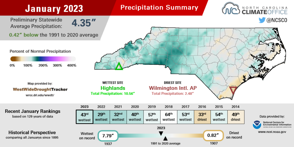
From west to east, precipitation had the state covered in January, which was wetter than normal in North Carolina. The National Centers for Environmental Information (NCEI) reports a preliminary statewide average precipitation of 4.35 inches, which ranks as the 43rd-wettest January since 1895.
Locally, Charlotte tied for its 25th-wettest January since 1879, with 5.67 inches of precipitation, or 2.18 inches above normal. Fresh off another 100-inch year in 2022, Highlands in southern Macon County is off to a wet start to 2023, with 10.56 inches and its 15th-wettest January on record.
The first half of the month saw a continuation of our weather pattern that began when the remnants of Hurricane Nicole moved through in mid-November. Weather systems continually brought rainfall to the Mountains and western Piedmont, but left southern and eastern areas considerably drier.
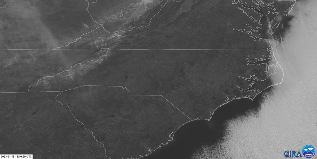
For instance, a cold front on January 4 brought more than 2 inches of rain to the southern Mountains but little to no accumulations along the coastline.
That pattern finally reversed beginning with a coastal low pressure system on January 22 that brought the highest totals across southeastern North Carolina. In areas such as Lumberton, that was only the second day with at least an inch of rain since Hurricane Ian moved through late last September.
And there was more where that came from. A cold front and another offshore low pressure system in the final week of the month collectively totaled almost 3 inches across the northern Coastal Plain.
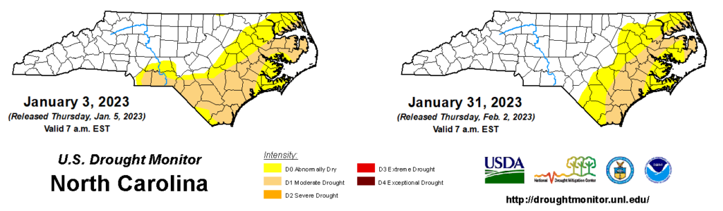
Those steady rain events finally brought drought recovery and relief for eastern areas that had been drier than normal dating back to the fall. Some coastal sites are still at a rainfall deficit over the past three months, including Wilmington at 4.44 inches below normal and Hatteras at 4.48 inches below normal. That’s reflected in deeper soil moisture conditions, which have yet to fully recover.
However, our late-January rain was a good start to digging out of drought and averting even more severe impacts this spring.
Wall-to-Wall Warmth
There were shades of spring but few signs of winter among last month’s temperatures. NCEI’s preliminary data shows a statewide average temperature of 46.8°F and our 8th-warmest January out of the past 129 years.
The warmth started early, with high temperatures hitting the 70s from Manteo to Murphy on January 3 as high pressure lingered off our coast. We again reached the 70s on January 5 and January 19 – the latter during our typical coldest part of the year.
Eastern North Carolina hit at least 60°F on 14 days or more last month. The 15 days that warm in Raleigh were tied for the 10th-most in any January, while Wilmington was in the 60s or warmer on 24 days, which was tied for its 4th-most in all Januarys.
Our nighttime lows didn’t offer much wintry chill either. It dropped below freezing just 10 times all month in Hickory, which was the 4th-fewest sub-freezing January days on record there. Even high atop Mount Mitchell, the coldest temperature last month was 7°F – a far cry from the -21°F on the morning of Christmas Eve last year.
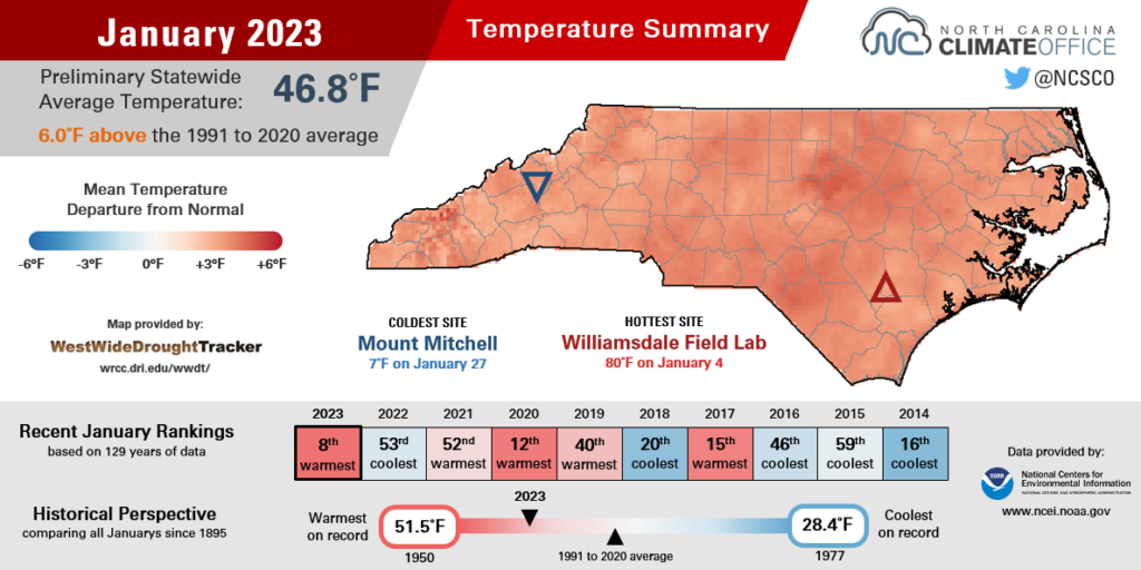
Altogether, the average temperatures in January ranked among the top ten warmest at most sites across the state, including the 8th-warmest in the past 90 years in Elizabeth City, the 6th-warmest since 1949 in New Bern, and the 3rd-warmest January since 1953 in Lincolnton.
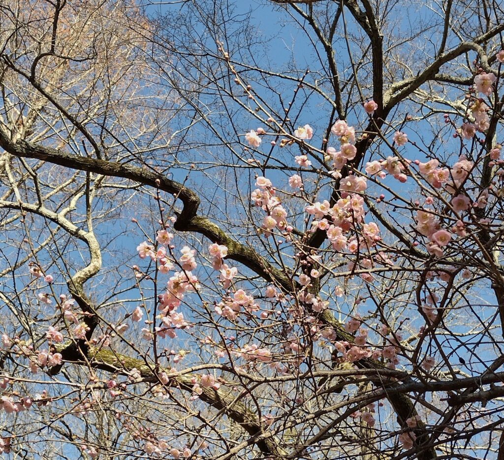
Such widespread warmth with so few cold nights had the unusual effect of sending trees blooming and flowers sprouting, all during the heart of winter. A CoCoRaHS Condition Monitoring observer in Watauga County noticed that “daffodils, an early spring flower, have emerged from the ground.” In Perquimans County, an observer reported that the warm, wet weather left the “grass turning green in spots and some trees are starting to bud.”
Given our atypical temperatures, especially compared to last year’s cool and snowy January, you can forgive Mother Nature for being confused about what season it actually was last month.
Snow Stays Away
With such warm weather, snow was scarce across the state in January, and as we enter the home stretch of the winter, it’s easier to list the areas that have seen snow so far this season than those that haven’t.
Measurable snow has been confined to the Mountains, with the highest season-to-date total of 26 inches on Beech Mountain, including 11.5 inches over a three-day period between January 13-15. Still, that’s only about half of the 50 inches they had recorded through the end of January last year.
Our state’s highest point, Mount Mitchell, has measured just 14.9 inches so far this winter compared to a normal winter-to-date total of 43.5 inches. Banner Elk has had 9.2 inches so far, which is also below its normal pace of 14.4 inches.
At lower elevations, snow has been even tougher to come by this winter. Waynesville has had only 1.3 inches, Boone has had 0.5 inches, and Cullowhee has only seen a scant 0.1 inches of snow so far this winter.
Piedmont and coastal locations have nearly been shut out from the snow entirely. The Greensboro and Raleigh-Durham airport stations each reported one hour of light snow overnight on January 14 with only a trace of accumulation, and areas farther south and east have yet to see any flakes.
So with one month left in climatological winter, is there hope of breaking our current snow drought? We looked at historical data from five Piedmont and Coastal Plain observing stations to see how often snowless winters through the end of January are saved by February – or even springtime – wintry events.
As you might expect, for areas farther west that tend to see more snow on average, it’s rarer to make it through January with no snow, and more common to see snow in February.
For instance, Charlotte has had 26 winters since 1940 with no snow through the end of January, and in 18 of those cases – or 69% of them – snow eventually arrived before the end of the season.
In winters like this one without any accumulations through January, both Greensboro and Raleigh have about a four-in-seven chance of seeing snow before the end of the season.
However, in eastern North Carolina, the odds are not in their favor, at least based on the historical data. Greenville has had 34 winters since 1959 finish snowless through January, and in only 13 of those – or 38% of the time – did they see any snow in February or later.
The conversion rate is even lower in Wilmington, which has only recovered from a snowless winter through the end of January one-quarter of the time. Historically, 42 of the 90 winters there since 1933 have finished with no measurable snowfall.
| Location | Years with Data | Winters with No Measurable Snow Through Jan. 31 | Winters with Measurable Snow Only After Feb. 1 | Odds of a Snowless Winter Ending After Feb. 1 |
|---|---|---|---|---|
| Charlotte | 82 | 26 | 18 | 69.2% |
| Greensboro | 120 | 33 | 19 | 57.6% |
| Raleigh | 79 | 21 | 12 | 57.1% |
| Greenville | 64 | 34 | 13 | 38.2% |
| Wilmington | 90 | 56 | 14 | 25.0% |
For those hoping for winter-saving snow in the next two months, recent history is on your side. Across the Piedmont, after the last three times we went snowless through January, February delivered with at least minor accumulations in 2020, 2015, and 2012 (or 2013, in the Charlotte area).
The most recent winter that finished without any measurable snow was 2011-12 in Charlotte, 2005-06 in Raleigh, and 1991-92 in Greensboro.
The current outlook is not exactly encouraging, though. The Climate Prediction Center suggests above-normal temperatures are likely for February – something we have also come to expect in La Niña winters – which means our windows for wintry weather may be closing for this year.