November saw overall cool temperatures with wet weather late in the month for North Carolina.

Record Lows Highlight a Cool Month
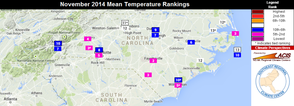
Almost from start to finish, cooler weather ruled the past month in North Carolina. Most stations saw average temperatures 3° to 7°F below normal, and the statewide average says it was our 4th-coolest November on record and the coolest since 1976. As the map below shows, many individual stations had one of their top ten coolest Novembers as well.
Early in the month, most of the Piedmont and Coast saw their first frost and freeze events of the season as low temperatures dipped into the 20s and 30s on November 3rd. It was a slightly later-than-normal first frost for most spots, but near their normal first freeze dates.
In the middle of the month, an Arctic air mass associated with a strong upper-level low pressure system moved over the eastern U.S. With clear skies over North Carolina, low temperatures plummeted into the teens on November 19th. Several daily low temperature records were broken, including in Wilmington (23°F), Raleigh (19°F), Fayetteville (17°F), Greensboro (16°F), and Charlotte (14°F). The previous day, our ECONet station on Mount Mitchell reached a low of -1.1°F and a high of just 8.1°F.
At the end of the month, the state saw near-normal temperatures, with the occasional warmer days ahead of frontal passages and cooler days behind them.
Above-Normal Precip. Thanks to Late-Month Rains
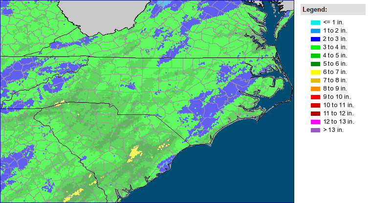
Through the first half of the month, most of the state saw less than an inch of rain. However, three precipitation events later in the month — on the 17th, 23rd, and 26th — meant a wet finish, making it the 33rd-wettest November out of 120 years of record.
The early-month dryness and low streamflows led the U.S. Drought Monitor to expand Abnormally Dry conditions across nearly two-thirds of the state. That coverage was reduced slightly last week and will likely decrease again this week because of our recent rains, which brought a widespread 1.5 to 3 inches of precipitation.
Along with rain, we saw a few snow events in the the Mountains. The first, on November 2nd, brought light accumulations to most of the region with some higher elevations reporting more than a foot of snow. Later on the 26th through the 28th, a low pressure system off the coast brought precipitation across the state and a few inches to some higher elevations, including two inches in Boone and 15 inches at Mount Mitchell.
A Quiet November Ends a Below-Average Tropical Season
No tropical systems were active in the Atlantic during November, so barring a rare December storm, the tropical season has come to an end. In total, the season had 8 named storms, 6 hurricanes, and 2 major hurricanes, all below the long-term average.
A slowly building El Niño event in the Pacific, which tends to strengthen trade winds and increase wind shear over the Atlantic, as well as cooler water across the main development region early in the season were factors in making it a relatively inactive season. The pre-season forecasts, which considered these and other factors, performed well. Most of these forecasts predicted 8 to 10 storms, 3 to 6 hurricanes, and just a few major hurricanes.
In North Carolina, the 2014 hurricane season will likely be remembered less for the number of storms and more for the one that hit us: Hurricane Arthur in July. Along with being our earliest-landfalling hurricane on record, Arthur brought category-two wind gusts, soundside storm surge, and a disruption to the Independence Day weekend along the coast.
Fall Finishes and Winter Begins
Meteorological fall is now in the books for 2014. The statewide seasonal averages say it was the 18th-coolest and 34th-wettest fall in the past 120 years. Although both rankings average out some of the variability during the past three months, they do highlight the overall cool conditions we saw this fall, especially later in the season.
September started warm and finished cool with wet conditions across much of the state. October saw average temperatures a few degrees above normal with dry weather outside the Mountains. And as we’ve seen, November was decidedly cool and wet across North Carolina.
Although our winter is beginning with temperatures slightly above normal this week, we expect the season as a whole to be on the cool and wet side with above-average snow and frozen precipitation. In case you missed it, our recent Winter Outlook series looked at forecasts from folklore, current El Niño conditions, the polar jet stream and its associated patterns, and our office’s 2014-15 winter outlook.