This is the second part of our 2014-15 winter outlook series. We previously covered forecasts from folklore, and today we dip into the Pacific to see how ENSO could affect our winter.
Perhaps the most commonly cited environmental predictor in seasonal outlooks is ENSO, or the El Niño/Southern Oscillation. ENSO describes the natural, cyclical change in sea surface temperatures (SSTs) in the equatorial Pacific Ocean, and it features a warm phase (El Niño) and a cool phase (La Niña).
While ENSO describes conditions in a relatively small piece of the globe, it has known impacts to the weather worldwide, including in North Carolina:
- During El Niño winters — including the most recent one in 2009-10 — we often see cooler and wetter conditions thanks to a stronger subtropical jet stream.
- La Niña winters — like 2010-11 and 2011-12 — are often warmer and drier as cold air and weather systems tend to stay to our north.
- Neutral winters — like the past two years — are more variable since atmospheric patterns besides ENSO tend to dictate our weather.
Current ENSO Conditions
This spring, warm water pooling near the surface made an emerging El Niño event seem inevitable. During the summer, SSTs cooled slightly and warmed again, but the SST anomalies remained below the El Niño threshold (0.5°C above normal), and ENSO’s atmospheric impacts, such as a weakening of the easterly trade winds, were not yet present.
So far in November, though, Pacific SSTs have warmed again and have consistently been 0.8°C to 0.9°C above normal — slightly above the half-degree El Niño threshold. For the coming winter, most climate models are predicting conditions to remain in the warm phase, likely as a weak El Niño event.
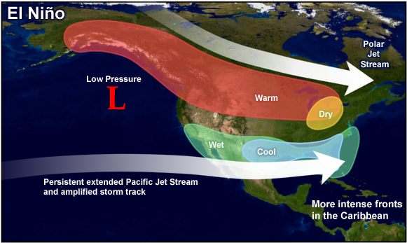
Whether or not we clear the half-degree hurdle to reach El Niño status, a warm-phase winter is likely to have a few main impacts on our weather. A strengthened subtropical jet stream should mean a more active storm track to our south, keeping us generally cooler and wetter than normal.
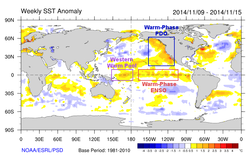
Slightly atypical this year are the warm SST anomalies in the western and central Pacific, as shown in the image below. Classic El Niño events see cooler SSTs in the west and warmer SSTs in the east. That gradient helps weaken the easterly trade winds, which allows more warm water to upwell in the east, leading to warmer eastern SSTs and stronger El Niño conditions. The lack of such an SST gradient this year is one reason why an El Niño phase has been slow to develop.
In past winters with similar warm water in the western and central Pacific, the slow or delayed increase in eastern SSTs meant El Niño conditions stayed stronger as the winter went along. In fact, two of the winters with the strongest central Pacific SSTs — 1968-69 and 2009-10 — saw widespread snow events for North Carolina in early March. That’s certainly no guarantee we’ll see the same this year, but it does hint that ENSO’s effects might stick around later in the season.
Another Pacific Indicator
The impacts of a warm-phase ENSO event may be enhanced by another pattern related to Pacific SSTs. The Pacific Decadal Oscillation, or PDO, is a slowly evolving pattern described by the SSTs in the north Pacific Ocean. Like ENSO, the PDO has a warm phase and a cool phase.
Some research suggests that when ENSO and PDO are in the same phase — both warm or both cool — the impacts from ENSO can be magnified. Currently, ENSO and the PDO are both in a warm phase, which would bolster a forecast for cooler and wetter conditions in North Carolina this winter. While it’s important to remember that ENSO isn’t the only driver of our winter weather, it is one of the most predictable indicators of our potential wintertime weather pattern, which makes it a valuable tool for seasonal outlooks.