This is the third part of our 2014-15 winter outlook series. Following our discussion of ENSO and its possible impacts, today we cover two other global climate patterns with connections to our winter weather.
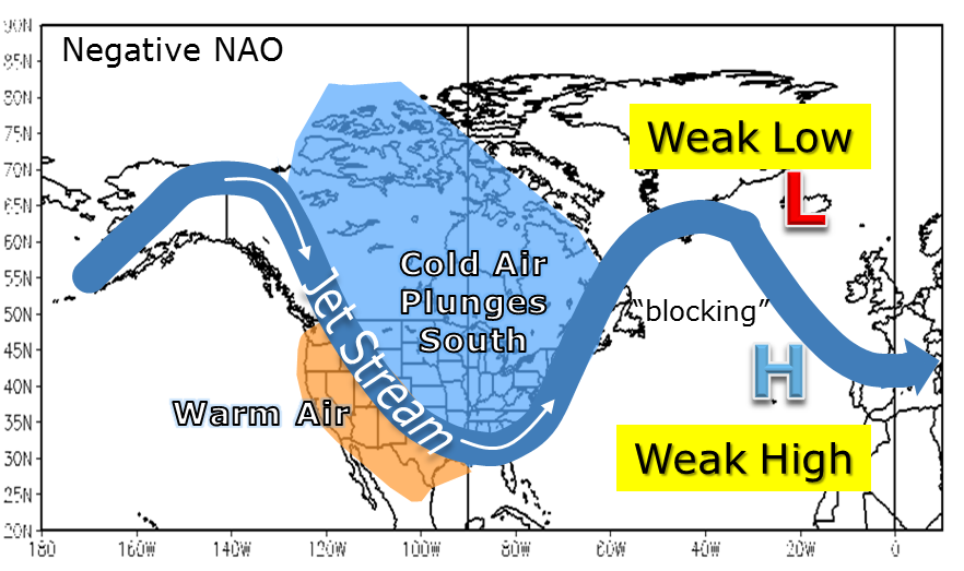
The Arctic Oscillation and North Atlantic Oscillation (AO and NAO, respectively) are two of the most important large-scale climate patterns that affect winter weather in the eastern United States. The AO and NAO are essentially measures of the strength of the polar jet stream in different locations: the AO over the North Pole, the NAO over the North Atlantic near Iceland. Each index consists of a negative and positive phase.
When the AO is negative, it means that the polar vortex — a semi-permanent upper-level low pressure system usually centered around the North Pole — is weaker than normal. That can also have downstream effects on weakening the North Atlantic Oscillation, which can put the eastern U.S. in a favorable pattern for wintry weather.
The AO and NAO are difficult, if not impossible, to forecast several months ahead of time because they change on a day-to-day basis and can go through a full cycle in two to three weeks. However, we can look at a few environmental indicators — one near the top of the atmosphere, the other at the surface — to see which direction the AO and NAO may lean in the coming months.
Quasi-Biennial Oscillation
The Quasi-Biennial Oscillation (QBO) is a measure of the wind direction about 15 miles up in the atmosphere — where the pressure is about 30 millibars, or just 3% of its surface value — around the equator. These winds reverse direction (oscillate) roughly every other year (quasi-biennially) between easterly (negative-phase QBO) and westerly (positive-phase QBO).
The upper-atmospheric winds measured by the QBO propagate downward in the atmosphere at a rate of about 1 kilometer per month. Research suggests that when this downward movement reaches the lower atmosphere during the Northern Hemisphere winter, it can trigger sudden stratospheric warming (SSW) events. SSW events can initiate the breakdown or weakening of the polar vortex, forcing the Arctic and North Atlantic Oscillations into a negative phase.
What does all that mean? A negative QBO phase in winter appears to be linked to a more favorable regime for wintry weather in North Carolina.
To see what this year’s QBO status could mean for us, we found several analog years — past years with similar conditions. First, we looked for years in which the QBO was near the same point in its biennial cycle. Since the QBO rapidly transitioned from a positive to negative phase this spring, that was the first requirement that had to be met.
With an October value of -23.86, the QBO has currently progressed to a strongly negative phase, defined as values less than -8, based on our research. That was the second requirement that an analog year had to meet.
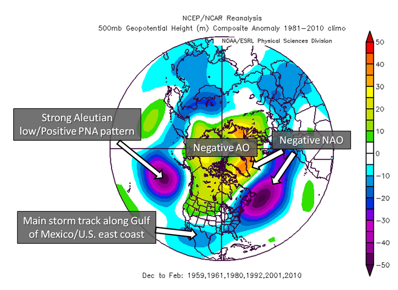
With those two factors in mind, we found six years that were close matches: 1958, 1960, 1979, 1991, 2000, and 2009. The typical upper-level weather patterns during these six winters holds some promise if you’re a winter weather fan in the eastern U.S.
As the map on the left shows, we see a strong signal for a vortex off the New England coast and a blocking signature over much of Canada and Greenland. This is a favorable pattern for cold and wintry weather in the Southeast US.
Siberian Snowfall
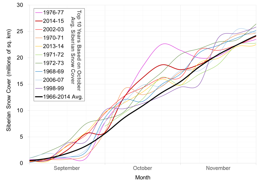
The QBO isn’t the only possible indicator of the wintertime AO and NAO phase. As we have previously discussed, the buildup of October Siberian snowfall can trigger important changes in the atmosphere that shape the wintertime jet stream pattern over the eastern United States.
As the chart to the right shows, this year (red line), snow fell at a torrid pace in early and mid-October, with only a slight decrease near the end of the month. It culminated in the October 2014 Eurasian snow cover ranking as the second-highest in the last 47 years. This strongly suggests that the Arctic Oscillation will be predominantly in a negative phase this winter.
Among the top-five snowiest Octobers in Siberia, two years (1967-77 and 2002-03) were followed by well below-average winter temperatures in the southeast U.S. Both winters also saw El Niño conditions in the Pacific.
The other two top-five years (1970-71 and 2013-14) came during cool-phase ENSO events, so the southeast saw near-normal wintertime temperatures while the cooler weather came in the Great Lakes and the Northeast — classic La Niña impacts.
As we discussed in our previous post, we expect warm-neutral or weak El Niño conditions for the coming winter, which suggests cooler temperatures similar to 1976-77 and 2002-03 may be likely.
The effects of the QBO and Siberian snowfall appear to already be influencing the atmosphere. Since mid-October, the AO has spent the majority of time in a negative phase with two dips into significantly negative territory. Meanwhile, stratospheric temperatures over Eurasia are warming at an impressive rate and are forecast to continue warming, which may signal a split of the polar vortex and a predominantly negative AO this winter. That would indicate a cooler pattern and more chances at wintry weather for North Carolina.