This is the final part of our 2014-15 winter outlook series, featuring our office’s official forecast for the coming winter.
Before we get to our outlook, let’s recap the current state of the atmosphere, specifically in the Pacific Ocean and factors that could shape the polar jet stream. We will also look some past years that appear similar to this one to see how their winters played out. We will finish with our winter outlook for 2014-15.
Pacific Patterns: ENSO and PDO
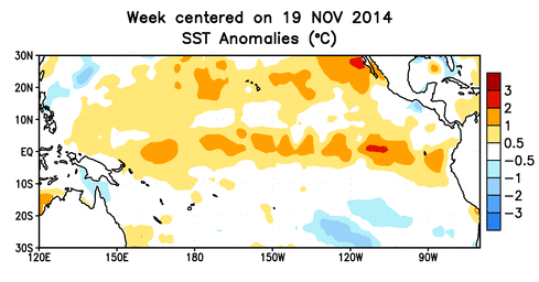
What’s Going On: Sea surface temperatures (SSTs) in the equatorial Pacific Ocean have been warmer than normal since the spring but have been slow to reach the El Niño threshold. Recent warming this month may put them over that mark, though. Read more about the latest conditions in our ENSO update post.
What it Means: El Niño winters are generally cooler and wetter than normal for North Carolina thanks to an enhanced subtropical jet stream, which can mean a more active storm track over us or just off the coast — a key ingredient for many of our winter storms. These impacts could be enhanced by the warm-phase Pacific Decadal Oscillation (PDO) pattern in the North Pacific Ocean.
Uncertainties: Is the recent warming of Pacific SSTs a sign that El Niño is here to stay for the winter, or another flash-in-the-pan temperature increase like we saw earlier this year? And if an El Niño event does develop, will it strengthen later in the winter, as we’ve seen in some past years with warm water in the western Pacific?
Polar Jet Stream Shapers
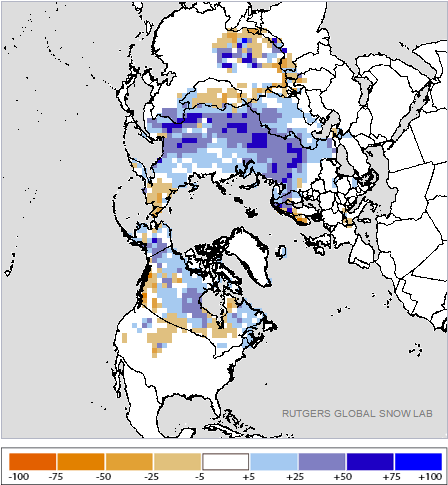
What’s Going On: This fall, we saw a rapid buildup of snow over Siberia, culminating in the second-highest average October Eurasian snow cover on record. Ample snow over Siberia helps build a high pressure system that can weaken the polar vortex — a large-scale upper-level low.
Meanwhile, upper-atmospheric winds over the equator have switched from westerly to easterly this year, putting us in a negative Quasi-Biennial Oscillation (QBO) phase. These easterly winds work from the top of the atmosphere down to achieve the same result — a weaker polar vortex. We described both patterns in more detail in our previous post.
What it Means: When the polar vortex is weak, the polar jet stream tends to meander a bit more, sometimes diving south over the eastern U.S. We often describe the strength and position of the polar jet stream by the Arctic Oscillation (AO) and North Atlantic Oscillation (NAO) phase. With each, a negative phase favors cool, wintry setups for North Carolina.
Uncertainties: As we’ve already seen this month, the AO and NAO are likely to be in a negative phase early in the winter thanks to the influences of Siberian snowfall and the QBO. However, there is more uncertainty about their status later in the winter.
Analog Years
Looking at past years with similar atmospheric conditions can give us some guidance about what may happen this winter. We looked for any winters with a warm-neutral or weak El Niño phase, warm water in the western equatorial Pacific, a positive PDO phase, a QBO phase that changed from positive to strongly negative earlier in the year, and October Siberian snowfall among the top 50% of all years.
The results gave five years that may be close analogs to the coming winter:
- 1958-59: the 24th-coolest winter on record for NC; saw a 6″+ snow across the eastern Piedmont in early December with several minor events in January
- 1976-77: the 5th-coolest winter on record for NC; memorable for the cold air — Raleigh had 10 days with single-digit temperatures — but lacking in any major wintry events
- 1979-80: the 47th-coolest and 14th-driest winter on record for NC; saw one major statewide snowfall in early March
- 1993-94: the 30th-coolest winter on record for NC; saw several minor snow events and a significant ice storm in mid-February
- 2009-10: the 13th-coolest and 4th-wettest winter on record for NC; saw widespread snow in mid-December, a mixed bag event in late January, statewide snow in mid-February with 6+” along the central coast, and an early March event with locally heavy snow
While these winters differed in terms of their impacts, they were all on the cool side for North Carolina.
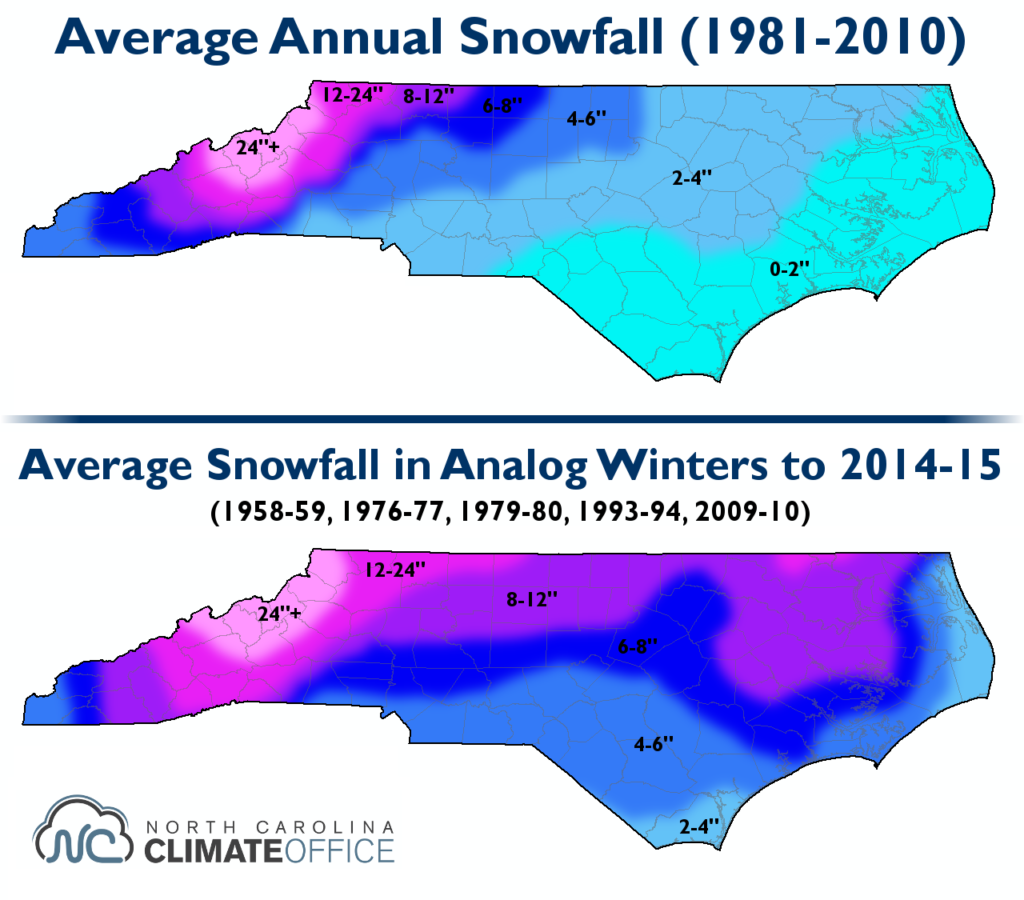
BOTTOM: Average snowfall in the five closest analog winters to 2014-15.
Our Winter Outlook
With the current atmospheric pattern and analog years in mind, here is our month-by-month winter forecast:
December
While above-normal temperatures appear highly likely for the first week of December, we expect the AO and NAO to eventually fall back into a negative phase and North Carolina to return to a below-normal temperature pattern as we’ve had for much of November. Snow or ice events are possible, especially if El Niño conditions continue to strengthen and an energized storm track brings moisture and storm systems our way.
January
Below-normal temperatures remain likely as a predominantly negative AO and NAO phase are expected. We expect regular minor (1 to 3 inches of snow, or light wintry mix) events thanks to an El Niño-amplified storm track. However, if the AO and NAO are strongly negative, we could enter a cold, dry pattern with fewer wintry events, like we did in 1976-77.
February and Early March
We predict near-normal temperatures, on average, with more variable temperatures throughout the month. We also predict a near to slightly above-normal chance of a significant winter storm. If El Niño conditions strengthen, it could make a coastal low or Nor’easter more likely. However, uncertainty about how ENSO and AO/NAO conditions might evolve gives us less confidence in this late-winter forecast.
The Bottom Line
Overall, we expect below-normal temperatures and above-normal precipitation for North Carolina this winter — both typical characteristics of El Niño winters. We also expect above-normal snowfall and frozen precipitation across the state, as well as an above-normal number of days with frozen precipitation. This is consistent with the analog years we examined and the favorable atmospheric patterns we’re likely to see.
We will follow the weather all winter and provide updates on our Twitter, @NCSCO, and here in the Climate Blog.