This is the third post in our summer outlook series. This post looks at the conditions in the Pacific, the Atlantic, and in North Carolina.
Following a near-normal spring, many folks are wondering what the summer holds for North Carolina. Will it have the heat of 2012, or be as mild as 2013? And how could a developing El Niño event in the Pacific affect our weather and the Atlantic hurricane season? Read on to find out in our summer 2014 outlook.
El Niño/Southern Oscillation (ENSO) Update
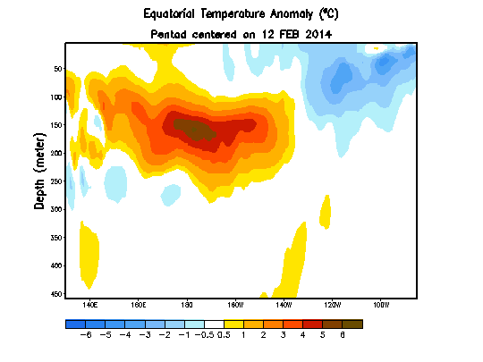
In our spring outlook a few months ago, we noted that many climate models were expecting El Niño conditions to emerge throughout the summer, and NOAA’s Climate Prediction Center issued an “El Niño Watch”. At that time, a Kelvin wave — an organized swell of water — had formed several hundred feet beneath the surface of the equatorial Pacific Ocean. That warm wave subsequently strengthened and moved eastward before emerging at the sea surface in April, as the animation on the right shows.
Sea surface temperatures across the eastern Pacific are now above normal, and the computer model consensus projects continued warming this summer. Although we often face the so-called “spring predictability barrier” for ENSO conditions this time of year, most forecast models are continuing to trend toward an emerging El Niño event. In fact, the model average gives at least a two-in-three chance of reaching El Niño status — SSTs in the ENSO region at least 0.5°C above normal — by the fall.
You can learn more about how El Niño conditions form and the developing 2014 event in this ScienceCast video from NASA.
Summer Outlook for North Carolina
If an El Niño event continues to develop, what effects might it have on North Carolina? At least this summer, the observable impacts may be limited. Although El Niño events are commonly associated with cooler, wetter winters across the Southeast, the summertime connections with our weather aren’t as strong. That’s because the jet stream is often weaker in the summer, and much of our summertime precipitation comes from small-scale convection, or thunderstorms, rather than larger-scale fronts and low pressure systems that are moved along by the jet stream.
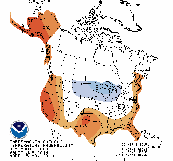
At least through the end of June, it appears that we may continue to see the variable conditions that we’ve had since last fall. Beyond that, the Climate Prediction Center expects an increased chance of above-normal temperatures for the eastern half of the state.
Of course, this is far from certain: Even the immediate coastal counties are only given a 40% chance of being warmer than normal for the summer. And the CPC does not have strong precipitation guidance for North Carolina, showing equal chances of above- or below-normal precipitation this summer. Again, such low forecast confidence is not unusual since the nature of our summertime conditions is not as predictable as in other seasons.
Pre-Season Hurricane Forecasts
Last week, we gave an overview of seasonal hurricane outlooks and the atmospheric and oceanic predictors they consider. During the past few months, research teams across the country have run their models to produce forecasts for this hurricane season. Here is a rundown of their forecasts:
| Forecast Source | # of named storms | # of hurricanes | # of major hurricanes |
|---|---|---|---|
| Long-term avg. (1950-2013) | 10.8 | 6.2 | 2.7 |
| NC State (issued Apr. 15th) | 8 to 11 | 4 to 6 | 1 to 3 |
| UK Met Office (issued May 16th) | 10 | 6 | (no prediction) |
| NOAA (issued May 22nd) | 8 to 13 | 3 to 6 | 1 to 2 |
| TropicalStormRisk.com (issued May 27th) | 12 | 5 | 2 |
| Florida State (issued May 29th) | 5 to 9 | 2 to 6 | (no prediction) |
| Colorado State (issued June 2nd) | 10 | 4 | 1 |
The developing El Niño conditions mean each of these forecast models is predicting below-normal tropical activity in the Atlantic this year. Also, sea surface temperatures in the Atlantic cooled this winter and early spring, which generally inhibits tropic storm development. Vertical wind shear — winds changing direction with height — hinders storm formation by tearing apart developing storms. Across the main development region in the Atlantic this year, the shear has been fairly strong — greater than 40 knots, or more than 40 mph, in some places.
As part of their 2014 seasonal outlook, the Tropical Meteorology Project at Colorado State identified five analog years (shown in the table below) in which the environmental conditions were similar to what we’ve seen so far this year. Each of those years saw a late-spring or early-summer emergence of El Niño conditions and near- or slightly below-normal Atlantic sea surface temperatures. Among those years is 1997, when we saw the beginning of the strongest El Niño event in recent history.
| Year | Tropical storms | Hurricanes | Major hurricanes |
|---|---|---|---|
| 1957 | 8 | 3 | 2 |
| 1963 | 9 | 7 | 2 |
| 1997 | 8 | 3 | 1 |
| 2002 | 12 | 4 | 2 |
| 2009 | 9 | 3 | 2 |
| Average | 9.2 | 4.0 | 1.8 |
None of the five analog years had more than 12 named storms, which is near the upper limit of most predictions for 2014. However, an inactive season does not mean strong or landfalling storms can’t happen. In 2002, Hurricane Lili struck the US, and North Carolina received damage along the coast from 1963’s Hurricane Ginny and 2002’s Hurricane Gustav, as well as damage and inland flooding from 1997’s Hurricane Danny.