Another year is in the books, and 2015 will go down as a warm and wet one for North Carolina, although we had some stretches of cool and dry conditions, too. Here’s our review of the weather and climate over the past year, including some notable numbers from across the state.
Annual Stats
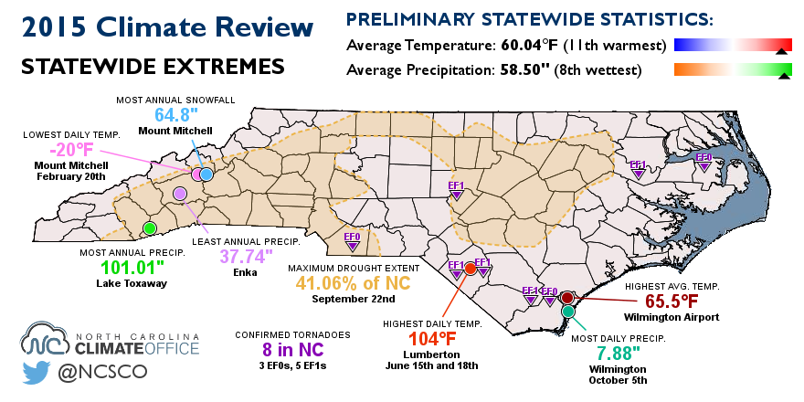
The statewide average temperature of 60.04°F makes 2015 the 11th-warmest year on record since 1895. The average precipitation of 58.50 inches ranks as the 8th-wettest year in that same period.
With an average temperature of 65.48°F, the warmest weather station in 2015 was the Wilmington Airport. The coolest weather station was Mount Mitchell with an annual average temperature of 44.97°F.
North Carolina’s climatological wettest location — Lake Toxaway in the southern Mountains — was also the wettest place in 2015. Last year, Lake Toxaway reported 101.01 inches of precipitation. That’s 9.5 inches more than normal.
In one of our state’s climate quirks, the driest and wettest locations are only about 30 miles apart. Across the mountain peaks north of Lake Toxaway, the rain shadow effect limits precipitation in Buncombe County. In 2015, the driest spot was Enka, just west of Asheville, where 37.74 inches of precipitation was reported. That was 1.65 inches below normal.
It was a quiet year for severe weather with just 8 confirmed tornadoes statewide. That’s the fewest since 1987 and tied for the 13th-fewest since records began in 1950. There was one tornado in May in Columbus County, five in June along the coast and another in Lee County, and one in December in Union County.
Seasonal Summaries
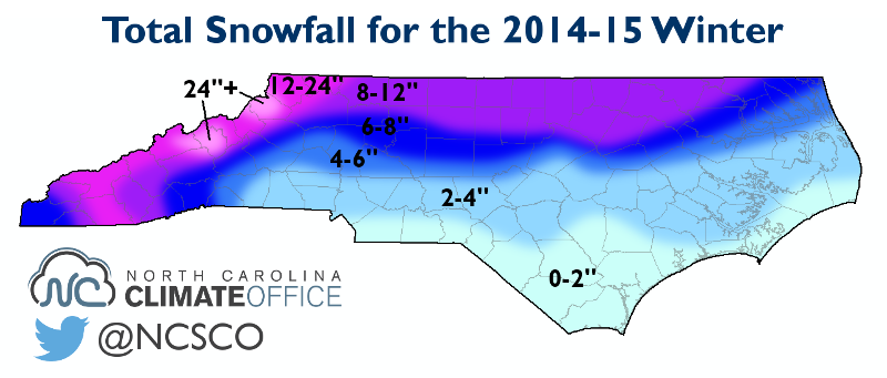
The year got off to a relatively mild start in January and early February, but the second half of February packed a wintry punch. A succession of snow and mixed precipitation events was punctuated by the coldest weather of the year.
During this time, Mount Mitchell’s temperatures dipped down to -20°F on February 20th. That was the lowest recorded temperature in North Carolina in 2015. Mount Mitchell finished the winter with 64.8 inches of snow, which was well below the normal of 92.3 inches.
The spring brought warm, dry weather particularly in the western half of the state. Charlotte received just 0.32 inches of rain in May. Along the coast, May was a bit wetter thanks to a visit from Tropical Storm Ana — our only direct encounter with a tropical system in 2015.
In the early summer, sizzling temperatures topped 100°F in parts of the state. In Lumberton, the high temperature hit 104°F on June 15th and 18th. The heat and ongoing dry weather saw drought return to North Carolina for the first time in more than two years.
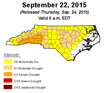
At the peak of the drought in mid-September, 41.06% of the state was classified in at least Moderate Drought (D1) with 10.32% of the state — mostly in the southwestern Piedmont and southern Mountains — in Severe Drought (D2) conditions.
The stretch of dry weather came to a sudden end in late September as we began one of our wettest weeks on record across the Carolinas. During this time, Wilmington received 7.88 inches of rain on October 5th — the highest daily precipitation total at any site in 2015.
Thanks to an El Niño-strengthened storm track to our south, the wet weather continued over the next few months. October and December were the wettest on record, and December was also our warmest on record.
As we head into 2016, El Niño remains one of the patterns shaping our winter, so it’s likely to be one of this year’s major weather storylines. Stay tuned to the Climate Blog all year as we cover the latest news and developments.