May saw above-normal temperatures continue and a return of dry conditions, especially in western North Carolina.

May Heats Up Across the State
Last month’s statewide average temperature of 67.76°F (1.42°F above the long-term average) made it the 29th-warmest May in the past 121 years. Several stations with shorter periods of record had one of their top-ten warmest Mays. That included Raleigh (9th warmest), Asheville (9th warmest), and Hickory (6th warmest).
Although above-normal maximum temperatures helped drive our warm May, we didn’t see a preponderance of 90 degree days. Raleigh, Charlotte, Fayetteville, and Wilmington each had just two days at or above 90°F last month, and Greensboro has yet to hit 90 this year. That makes 263 days and counting since Greensboro’s last 90° occurrence on September 11, 2014, which is the 38th-longest such streak on record. However, it’s far from the record, which came from July 18, 1971, to July 18, 1972 — a full year, or 366 days, between 90° readings in the Gate City.
Instead of widespread 90s, we saw many days with highs in the mid to upper 80s — slightly above our normal May highs in the upper 70s or low 80s. That warm pattern was due in part to an upper-level ridge over the southeast that lingered for much of the month.
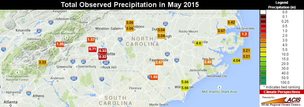
Dryness Returns to Western NC
That ridge also kept us dry. The statewide average precipitation of 2.66 inches (1.30 inches below the historical average) ranks as the 19th-driest May on record. Almost the entire state received less than 75% of its normal May precipitation, and the few wet spots along the coast received most of their rain from one event — Tropical Storm Ana’s landfall on May 10th.
The dry conditions were worst in the western and southern tiers, where many sites saw less than two inches of rain all month. Charlotte received just 0.32 inches of rain, which all came on a single day. That total ranks as the 2nd-driest May and the 9th-driest month since 1940 at the Charlotte Airport. Nearby Monroe recorded 0.34 inches of rain all month, making it their 3rd-driest May in the past 116 years.
Even on the heels of a wet April, the warmth and dryness in May led to increased evaporation and a return of Abnormally Dry conditions. The US Drought Monitor’s May 26th update included 49% of the state in those D0 conditions, although none of the state is officially in a drought quite yet. However, the clean slate for summer we discussed last month is quickly becoming etched by the recent dryness.
Spring was Warm, Dry, with Limited Severe Wx
Our wet April notwithstanding, this meteorological spring — March, April, and May — was warm and dry across the board. The preliminary rankings show it was the 38th-warmest and 39th-driest spring on record for North Carolina.
| NWS Office | Spring 2015 | Spring 2014 | Spring 2013 | Spring 2012 | Spring 2011 | Spring 2010 |
|---|---|---|---|---|---|---|
| Wilmington, NC | 10 | 26 | 12 | 72 | 59 | 17 |
| Newport, NC | 10 | 23 | 3 | 29 | 18 | 1 |
| Wakefield, VA | 13 | 40 | 29 | 15 | 92 | 38 |
| Blacksburg, VA | 20 | 21 | 46 | 96 | 219 | 94 |
| Raleigh, NC | 39 | 63 | 20 | 92 | 107 | 49 |
| Greer, SC | 47 | 74 | 58 | 191 | 207 | 109 |
In some ways, periods of warm and dry weather are fairly typical this time of year as we begin to receive more of our precipitation from convective showers and thunderstorms, which tend to be fairly localized.
Although we did see storms popping up this spring, we didn’t see many severe storms. The National Weather Service offices that forecast for all or part of North Carolina issued fewer than 50 severe thunderstorm warnings each over the past three months. As the table to the right shows, that’s among the fewest in the past six years for each office.
There was also just one confirmed tornado all spring: an EF-1 near Bolton in Columbus County on May 21st. A waterspout was also reported to have come ashore on Roanoke Island on May 11th, causing tornado-like damage around Manteo.
From 1991 to 2010, we averaged about 12 tornadoes each spring, and May is historically our most active month for tornado activity, according to research by the Southeast Regional Climate Center. That puts this spring’s tornado activity well below average as well.
What does the summer hold in store? In case you missed it, last week, we released our Summer and Tropical Outlook that includes a closer look at the developing El Niño and how it might affect our weather. Stay tuned throughout the summer as we cover whatever the weather has to offer.