A Dry August Concludes a Warm Summer
August continued a recent dry pattern that has seen drought conditions emerge across parts of North Carolina.
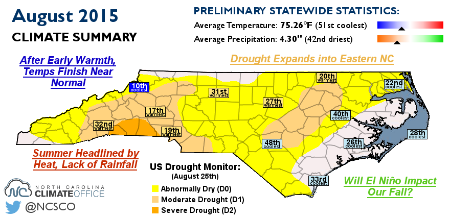
After Early Warmth, Temperatures Finish Near Normal
Warm periods in the first week of the month and the middle of the month balanced out with several cooler days to give near-normal temperatures, on average. The statewide average temperature of 75.26°F ranks as the 51st-coolest (or 71st-warmest) August on record.
The hottest day of the month came on August 5th when high temperatures climbed into the mid to upper 90s. Our Sandhills ECONet stations in Lilesville and Hamlet reported highs of 100°F and 101°F, respectively.
That was one of the relatively few 90° days in August for eastern North Carolina. Wilmington hit 90°F just six times all month, New Bern reached that mark seven times, and Greenville made it that high on eight days. Even Fayetteville, which set the state’s all-time high temperature record of 110°F in August 1983, hit 90°F or higher just nine times this August.
Ongoing drought conditions in the southwestern Piedmont meant temperatures stayed slightly warmer. Charlotte hit 90°F 19 times last month — the 18th-most all time at that site, but well short of the record from 2007, when all 31 days hit 90°F or above.
As we move into September, the heat should become less frequent and less intense. Our normal high temperatures fall from the upper 80s to the low 80s by the end of September, and most sites average just two to five days reaching 90°F. However, some years — most recently 2007 and 2010 — have seen 10 or more such hot September days, so lingering warmth to start meteorological fall is always a possibility.
Drought Expands into Eastern NC
Another month without much widespread rainfall made for a drier-than-normal August. The statewide average precipitation of 4.30 inches ranks as the 42nd-driest August since 1895.
Reversing the recent trend of wetness in the east and dryness in the west, the eastern Piedmont and northern Coastal Plain were the driest spots last month. Many sites across the region finished the month two or more inches below normal, with Elizabeth City‘s deficit of 4.5 inches ranking as the fourth-driest August on record.
Lingering dryness led the US Drought Monitor to introduce Moderate Drought (D1) conditions along a corridor from Fayetteville through Goldsboro and Rocky Mount. The Central Piedmont is now classified in Abnormally Dry (D0) conditions.
Some areas of state saw improving drought conditions in August. The Triad, for example, is back in D0 conditions after being classified in Moderate Drought earlier in the month. Greensboro picked up 7.04 inches of rain — 3.2 inches more than normal — which helped alleviate some of the recent dryness. However, streamflows across western North Carolina remain at or below the 15th percentile, so most of the region remains in Moderate or Severe Drought conditions.
Summer Headlined by Heat, Lack of Rainfall
Most of the summer featured a combination of warm and dry weather. For June, July, and August, the statewide average temperature of 76.29°F ranks as the 26th-warmest, and the average precipitation of 13.47 inches ranks as the 33rd-driest out of 121 years of record.
The summer got off to a hot start as a mid-June heat wave pushed temperatures to the 100° mark. By the end of the month, the heat and dry weather saw Moderate Drought conditions return to North Carolina for the first time in more than two years.
July didn’t have the same extreme heat as June, but it remained warm and dry. That allowed Moderate Drought conditions to expand and Severe Drought conditions to emerge just west of Charlotte.
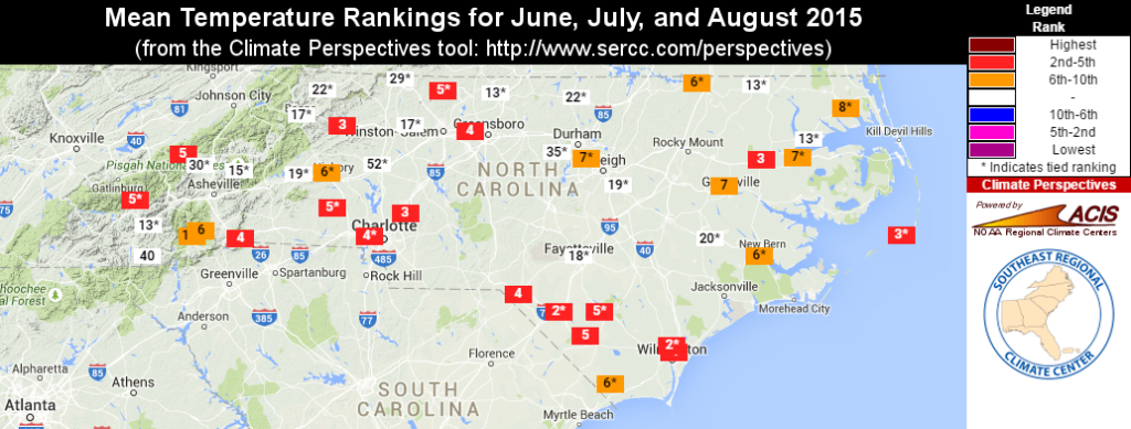
Even including near-normal temperatures in August, many stations had one of their top-ten warmest summers on record. That includes the fourth-warmest summer out of the past 70+ years for Charlotte, Greensboro, and Wilmington. Raleigh finished the summer about a degree above normal, making it the seventh-warmest summer on record there.
The lack of rainfall is evident in the summertime precipitation deficits. Charlotte was 3.7 inches below normal, and Hickory and Statesville were also more than three inches short of their normal precipitation, ranking among their top-ten driest summers on record. Precipitation deficits were also apparent across the coast, as sites from Wilmington north to Elizabeth City all finished at least an inch below normal. A few locations, primarily along the northern tier and immediate coast, finished the summer with above-normal precipitation, which is typical of our summertime pattern of hit-or-miss showers.
The general lack of rain was also evident in the lack of severe weather. After six confirmed tornadoes in June, none were reported in July or August. The National Weather Service offices in Raleigh, Newport, and Wilmington issued a combined 11 tornado warnings all summer, and the Greenville-Spartanburg and Blacksburg offices issued none.
Will El Niño Impact Our Fall?
In the central Pacific Ocean, sea surface temperatures have continued to warm and are now more than a degree and a half above normal. That puts us in a bona fide El Niño event with a strength rivaling some of the strongest we’ve ever seen at this point in the year.
We’re already noticing one impact of El Niño: Conditions in the tropical Atlantic have been less conducive to tropical storm development, and the systems that have formed have encountered high wind shear and struggled to survive. As we approach the peak of hurricane season this month, the reduced activity in the Atlantic is expected to continue.
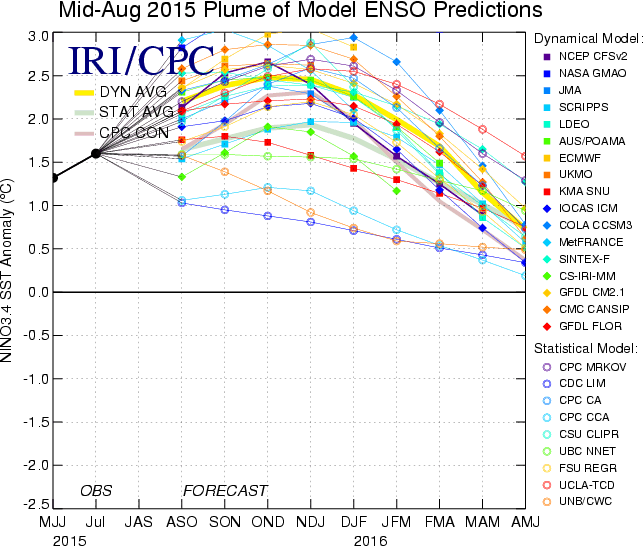
El Niño’s impacts on our weather are usually most prominent in the winter, but given the strength of this year’s event, we could begin to see its effects this fall. Many climate models are predicting a wet fall for the Southeast US, along with above-normal temperatures for North Carolina.
A wet fall isn’t a guarantee during an El Niño pattern — during previous strong El Niños in 1982 and 1997, our fall precipitation was about average. But if the current El Niño remains in tact and strengthens as expected, our confidence in having a wet winter will increase.
Over the next few months, we will keep a close eye on other atmospheric indicators of our possible winter conditions, and in November, we will release our annual winter outlook for North Carolina.
- Categories:


