
The third tropical storm to affect North Carolina in the past two months targeted the Mountains with heavy rainfall and flooding this week.
Like Claudette in June and Elsa in July, Tropical Storm Fred tracked through the Gulf of Mexico before making landfall along the Gulf coast, and its remnants had an impact on North Carolina — this time in the western part of the state.
Despite its strength as only a tropical depression as it crossed the Appalachians, Fred had a potent punch with rapidly rising rivers, flooded roads, and even a few tornadoes. To understand the reasons for and extent of these impacts, we must first rewind a few days.
The Rainfall Before Fred
Even before Fred reached the Florida coastline, parts of western North Carolina had already endured a wet weekend. Moisture moving in from the south fueled locally intense thunderstorms on Saturday, Sunday, and Monday.
During that three-day period, our ECONet station at Frying Pan Mountain on the Haywood/Transylvania County line recorded 6.08 inches, all prior to Fred’s arrival.
The Asheville Airport picked up 4.80 inches during that time, which left the nearby French Broad River in Fletcher rising with little time to recover before the next storm hit.
Fred Pours More
As Fred moved through the Mountains on Tuesday, it still packed plenty of precipitation and power. Frying Pan Mountain picked up an additional 7.47 inches in just 36 hours. In the past 7 days, that station has recorded exactly 14 inches of rain, which is its wettest week since being installed in November 2004.
Other ECONet stations across the southern and central Mountains reported storm totals exceeding six inches, including 6.55 inches on Sassafras Mountain, 6.47 inches on both Wayah Bald Mountain and Bearwallow Mountain, and 6.02 inches in Spruce Pine. Our Spruce Pine and Burnsville stations both set all-time daily precipitation records on Tuesday, with 5.4 inches and 4.26 inches, respectively.
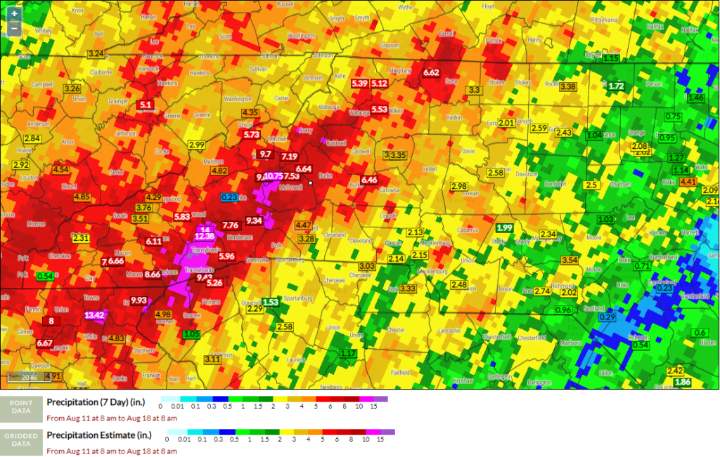
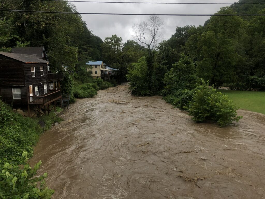
Near Brevard, weather radar estimates more than ten inches fell between Sunday morning and Wednesday morning. The nearby French Broad River in Rosman crested above flood stage twice in that period: after Monday’s storms and after Fred’s additional rainfall, at that point reaching its second-highest crest on record.
In Buncombe County, the French Broad in Asheville and the Swannanoa River at Biltmore both hit moderate flood stage on Wednesday.
West of there, the Pigeon River reached major flood stage early Wednesday morning with its fourth-highest crest on record, and the river inundated bridges and roads in the town of Canton.
That area was hit particularly hard by the storm. Haywood County Emergency Services reports around 35 people still unaccounted for with search-and-rescue operations ongoing, and “significant damage to roads and bridges, especially in Cruso”.
Along with rainfall, Fred produced at least three confirmed tornadoes. The National Weather Service in Greenville-Spartanburg, SC, confirmed an EF-1 tornado moved through Iredell and Alexander counties on Tuesday morning, and NWS Blacksburg surveyed two short-lived EF-0 tornadoes in Wilkes County from early Tuesday afternoon.

Disappearing Dryness
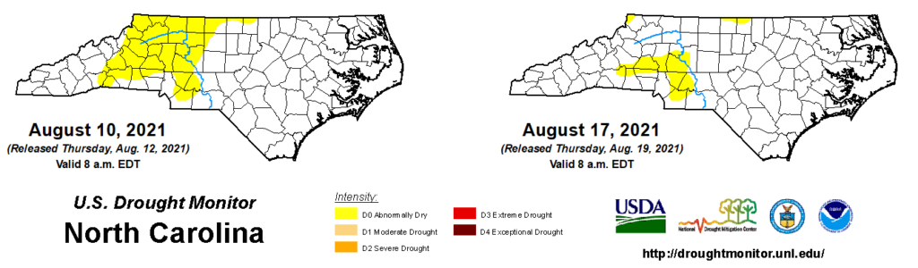
Since the late spring, the western Piedmont and Foothills had grown increasingly dry, as the bulk of rain from Claudette and Elsa passed by to the east and summertime showers were scarce across that region. As of last Friday, Hickory was 3.7 inches below normal since June 1 and Highlands had a seasonal deficit of 1.6 inches.
However, the recent rains helped reverse that dry weather in one fell swoop. After the wet week including Fred, most of North Carolina is now at a precipitation surplus. Hickory is now 0.5 inches above normal and Highlands is 7.3 inches above normal for the summer so far.
The current drought status reflects only rains falling before 8 am on Tuesday, but it already shows a reduction in Abnormally Dry (D0) conditions in the northern Mountains and northwest Piedmont, reflecting last week’s rainfall and the initial precipitation from Fred. The bulk of Fred’s rain will be considered for next week’s drought map.
Another Mountain Storm
While tropical storms reaching the Mountains aren’t as common as those along the coast, Fred does has historical company among flood-producing storms crossing western North Carolina.
September 2004 was particularly notable for its three storms that each produced heavy rainfall in the Mountains, and their additive effects that included almost-overflowing reservoirs and landslides on the rain-weakened slopes. Many of the record river crests in the Mountains were set during that extremely wet month.
Fred’s track was very similar to Frances from that year, while its rainfall totals more closely matched those from Ivan — the second of the three storms whose impacts were exacerbated by its timing just ten days after Frances.
Last year also saw a succession of storms from the Gulf that affected the Mountains, most notably with the remnants of hurricanes Delta and Zeta moving through in late October.
These recent soaking storms are no fluke, either. North Carolina’s first Climate Science Report notes that extreme rainfall — including totals exceeding three inches per day, like many areas saw from Fred — is becoming more frequent due to climate change:
Heavy precipitation accompanying hurricanes that pass near or over North Carolina is very likely to increase, which would in turn increase the potential for freshwater flooding in the state.
From the North Carolina Climate Science Report
With the typical peak of hurricane season about three weeks away, and an above-normal season still expected, Fred may not be the last storm to soak the state this year.