It was the winter that kept us guessing. Just when we thought our warm fall would persist into 2018, a record-setting cold snap ensued. We thought the large-scale pattern wouldn’t be favorable for wintry weather, yet most of North Carolina received above-normal snowfall. And amid indicators of ongoing dry weather, we actually came out of drought.
So exactly what happened this winter, and why was it so unpredictable? In today’s winter recap, we’ll share the final stats and snow totals, review seasonal predictions from folklore and our own winter outlook, and take a look at the conditions this spring.
Seasonal Stats and Snowfall
It may come as a surprise given some of those memorable wintry events, but overall, the meteorological winter — December, January, and February — was slightly warmer and drier than normal.
The statewide average temperature of 42.11°F was 0.33°F warmer than the 1981 to 2010 average, ranking as our 51st-warmest winter since 1895. While our cold January stands out, it was balanced by near-normal temperatures in December and our 2nd-warmest February on record, giving that slightly above-normal wintertime average temperature. Also remember that our recent cool March weather doesn’t count toward the meteorological winter.
The statewide average precipitation of 10.53 inches was 0.62 inches below the 1981 to 2010 average, making it our 56th-driest winter in the past 123 years. Several rain and snow events were packed into the second half of January, but otherwise, December was dry in the western two-thirds of the state and February was dry in the eastern two-thirds, leading to that slightly below-normal average precipitation.
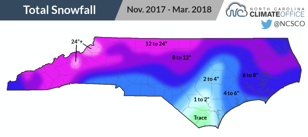
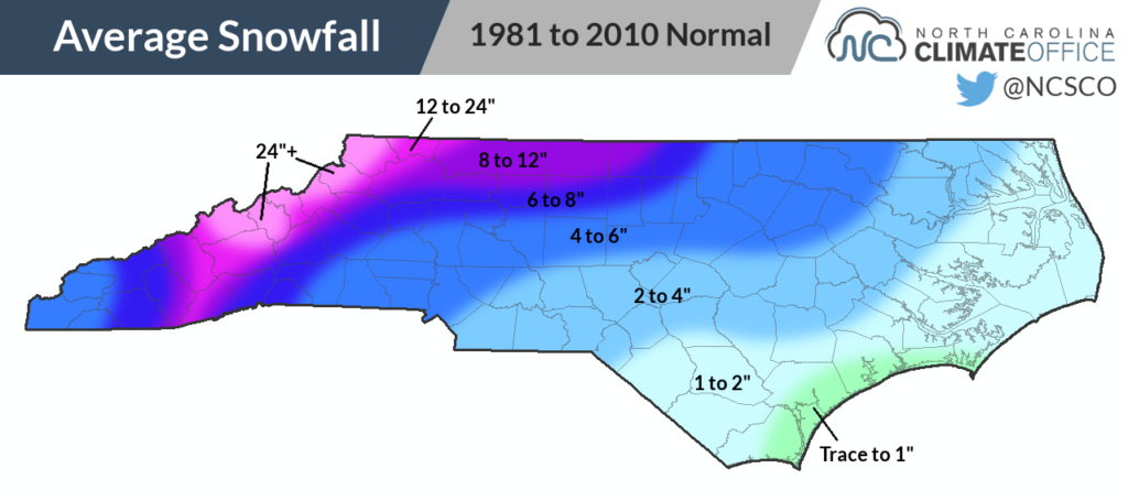
Those snow events were perhaps the most memorable part of this winter, and altogether, most of the state received above-normal snowfall for the season. Across the state, there were three significant wintry events — on December 8-9, January 3-4, and January 17-18.
We also had recent measurable snowfall events on March 12 and March 24-25. While March snows aren’t all that uncommon, snow this late in March definitely is. The last time Greensboro had measurable snow this late in the season was on March 30, 2003, and the last time in Raleigh was way back on April 11, 1989!
Raleigh‘s 8.9 inches of total snow this winter was the most since 2004, when 14.9 inches fell. Greensboro (14.7 inches), Charlotte (4.2 inches), and Hatteras (3.5 inches) all had their snowiest winters since 2014. With 8.4 inches of snow, Edenton had its second-highest wintertime snow total since 1990.
While recent La Niña winters such as 2006, 2008, and 2012 all featured limited snowfall in North Carolina, the 2017-18 winter isn’t alone among La Niña years in which we did see significant snow events. Another recent snowy winter, 2011, was also a La Niña year, as was the 2000 winter — famous for the record-setting January 25 snow event in the eastern Piedmont.
Forecasts from Folklore
Among the weather folklore we reviewed last fall, none captured every aspect of our multifaceted winter, but some did better than others.
The colored bands on the winning woolly worm at last year’s Woolly Worm Festival in Banner Elk supposedly foretold a snowy start and end to winter — which was true — but it also expected near-normal temperatures in late December and through much of January, which is when our coldest weather was in place.
The Farmers’ Almanac called for “Wintry Chill” with “Wet & White” conditions in North Carolina and Virginia. Although our average conditions were a bit warm and dry, this winter will definitely be memorable for the snow and stretch of cold weather, so we’ll count that as a mostly correct prediction.
The Old Farmer’s Almanac predicted mild, wet weather, and while that may have been true for parts of late January and early February, other parts of the winter were cool, dry, or both.
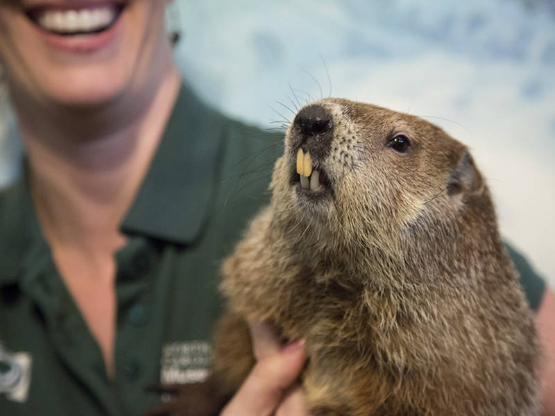
North Carolina’s groundhogs offered mixed predictions, with Sir Walter Raleigh forecasting an early spring and Queen Charlotte declaring six more weeks of winter. Given our spring-like warmth in February and the return of wintry weather in March, we’ll call them both half correct.
Our Outlook Reviewed
In our winter outlook issued back in November, we predicted drier-than-normal conditions with near- to above-normal temperatures, which was true for the winter as a whole. December wasn’t as warm as we expected, though, and while our coolest conditions did come in January, we never imagined seeing such a lengthy stretch of frigid weather.
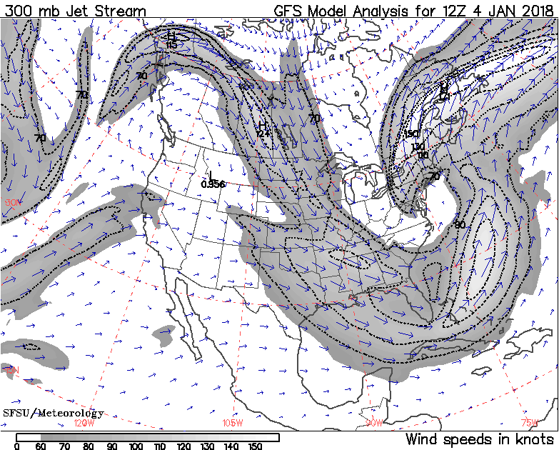
Based on the typical La Niña-affected jet stream pattern that tends to steer weather systems to our north, we expected to see fewer than normal wintry events, which was far from the case. Instead, the wildcard factors we mentioned — a weak polar vortex and a southward-sagging polar jet stream — played a much greater role in our winter than La Niña did.
The polar vortex weakened late last fall, and by early this year, a weak and wavy polar jet stream set up a persistent trough across the eastern US (see the map below) that funneled in cold, Arctic air.
A small westward shift in that trough in February reversed our weather pattern from cold to warm, and in March, we’ve seen another shift back to the east that caused cooler conditions to return to North Carolina.
Those shifts from week to week and even day to day have given us such volatile and at times unpredictable weather, including record-setting streaks of both below-freezing temperatures in January and above-freezing temperatures in February and March.
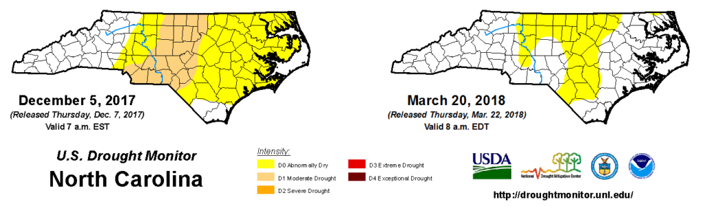
Our final prediction — for drought to expand and intensify — seemed like one of the safest given our dry fall and expected dry winter. Even though the past three months were slightly drier than normal, we received enough precipitation to help streamflows, reservoirs, and topsoil moisture levels recover and alleviate drought conditions. The snowfall helped, too, since a slow snowmelt ensured steady inflows into streams, lakes, and soils with limited runoff.
Spring Conditions
As of last week, none of the state is classified in Moderate Drought by the US Drought Monitor, which seemed nearly unthinkable entering the winter. While Abnormally Dry conditions do remain across parts of the Piedmont and southern Coastal Plain, mainly due to soil moisture deficits at deeper levels, reservoirs across the state are at or above target levels entering the warm season — whenever it decides to arrive for good.
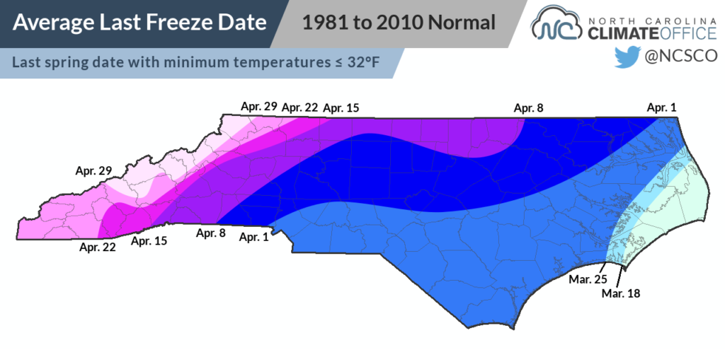
Heading into April, we expect to continue seeing a variable jet stream pattern that will bring us some warmer days, cooler days, and regular shots of rainfall. That could also mean a spring freeze event; remember that our climatological last freeze doesn’t occur until the final week of March or the first few weeks of April.
In the Pacific, the La Niña pattern remains in place, but with the bubble of cool water beneath the ocean surface subsiding, we expect to transition back to ENSO-neutral conditions this summer.
That’s not likely to have much effect on us, at least in the short term. ENSO’s impacts on our summer weather are limited since the north-to-south temperature differences are smaller and we see most of our precipitation from localized showers and storms instead of systems moved along by the jet stream.
Over the next three months, the Climate Prediction Center says warmer-than-normal conditions are likely across the southern half of the US, but calls for equal chances of above- and below-normal precipitation — likely a sign of that variable pattern continuing.
Because of that pattern’s influence over the past few months, some key parts of our winter outlook were wrong, but since it means entering the spring with few lake level, precipitation, or soil moisture deficits, we’ll gladly take one for the team this year.