This is the second part in our four-part 2013-14 winter outlook series. The first post recalled some major winter storms in North Carolina and their causes and impacts, and this one discusses the frequency of these events.
Nearly every year in North Carolina, a handful of minor winter weather events cause closings, delays, and disruptions to daily lives. However, the bigger, more impactful events occur less frequently. But just how often do we see major snow and ice storms? To examine this, we used our Winter Storm Database to identify major events since 1959.
We found 69 major snowstorms (in which parts of the state received at least 6 inches of snow) and 51 major ice storms during the 54-year period of record. However, these numbers are slightly deceiving for several reasons. First, they include events in which the snow or ice were isolated to the Mountains, where those kinds of events are not as rare. Also, they are slightly skewed by years in which multiple events occurred, often in quick succession. For example, in 1960, three snowstorms with statewide impacts occurred in a one-month period, including events on back-to-back weeks in mid-March. The 1995-96 winter saw five ice storms affect some part of the state, capped off by an event on February 2nd that left thousands without electricity and had power companies calling it “the worst ice storm ever”.
Ignoring Mountains-only events and accounting for winters in which multiple events occur, there are 33 years with a major snowstorm and 24 years with a major ice storm. Put another way, 61% of all winters since 1959 have had a major snowstorm, and 44% have had a major ice storm. That means that each type of event has historically occurred somewhere in the Piedmont or Coastal Plain about every other year.
As we look more closely at these events, here are a few frequently asked questions (and answers) about major winter storms in North Carolina.
Are major events least common along the coast?
As the graph below shows, the Coastal Plain has seen the fewest major snow and ice events since 1959, so yes, they are less common there. The proximity to the relatively warmer waters of the Atlantic Ocean moderate the air in this region, so wintry events often feature more rain and a delayed arrival of air cold enough to support snow.
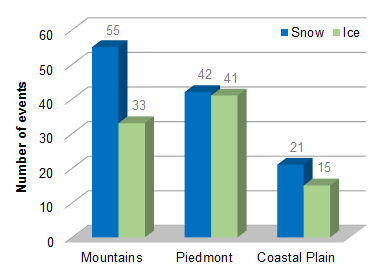
Also, during cold air damming events that are often associated with ice storms, the dome of cold air is often shallowest over the eastern part of the state, so falling precipitation has less time to freeze near the surface. These transition zones often occur along the I-95 corridor, which is in roughly the same location as the fall line — the separation between the Piedmont and Coastal Plain marked by an elevation change of more than 200 feet — so Interstate 95 serves as a convenient geographical reference.
Significant events are still possible along the coast, though. In February 2010, a low-pressure system tracked several hundred miles off the coast, which meant the heaviest snow fell along the central Coastal Plain. In the Christmas storm later that year, a heavy snow band brought the greatest accumulations to Wilson, Nash, Edgecombe, and Halifax counties. Parts of the northeastern coast near the Virginia border also saw close to a foot of snow in that event.
Is it rare to get a big event in December or March?
The winter solstice is not until December 21st, so it seems unusual to get winter weather before then. However, big events in December may not be as rare as you think. As the chart below indicates, December is actually the second most common month for major ice storms, and has just as many major snowstorms (8) as February.
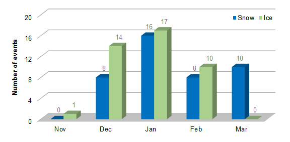
Interestingly, March is the second-most common month for snow events, proving that it is certainly still possible to see snow then as well. Although temperatures are usually on the rise again by March, it is not unheard of to have a quick burst of cold air followed by a coastal low that strengthens over the warming waters of the Gulf Stream. That setup can bring us a late-winter wet snow event, like the ones we had in consecutive years during 2009 and 2010.
Are we due for another big event this year?
For most of the Piedmont, the last major ice event was on January 10-11, 2011, and the last big statewide snow event was the Christmas 2010 storm. So after two fairly inactive winters, are we in the crosshairs for a big wintry event this year?
Not necessarily. Winter weather does not recur on any set time intervals. Just as we can have multiple big events in one year, we can also go several years without much frozen precipitation to speak of. For example, between 1991 and 1995, most of the eastern half of the state did not see more than an inch of snow.
Although the historical data suggests that there is a big event somewhere in North Carolina about every other year, we know that weather patterns — not statistics — ultimately dictate how our winters turn out. Stay tuned to the blog later this week as we look for insight about this winter’s forecast from some famous folklore and more robust scientific sources.