The El Niño of 2015-16 has passed away after a short but ruinous battle with cool water in the equatorial Pacific Ocean.
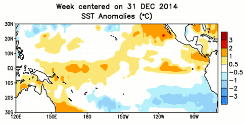
Following multiple attempts during the summer and fall of 2014 to conceive an El Niño, this event was born during the late winter of 2015 to its parent phenomena: warming water and westerly winds in the west-central Pacific Ocean.
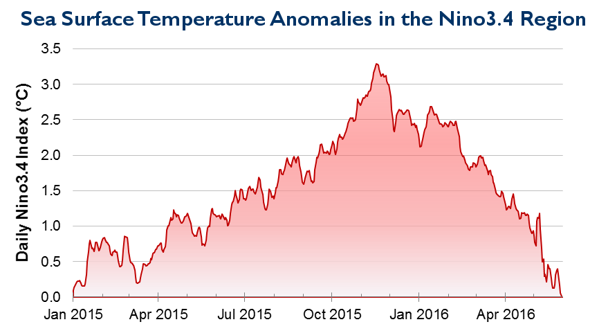
Early in its life, El Niño — known as “The Little Boy” to some — was shy and slow to emerge. Sea surface temperature anomalies hovered near the +0.5°C El Niño threshold during the winter and early spring of 2015. However, positive reinforcement from warm water beneath the ocean surface helped the El Niño develop and strengthen into a confident young oceanic event.
Its impacts also began extending to the atmosphere. During the spring and summer of 2015, it gave life to 26 named tropical storms — the second-most on record — in the eastern Pacific region. That included Hurricane Patricia, which in October 2015 became the powerful grandstorm of the ongoing El Niño, reaching Category 5 status off the west coast of Mexico.
By the fall of 2015, El Niño began having impacts in the southeast US through its work with the jet stream. Record rainfall in the Carolinas during late September and early October is partially attributed to El Niño via the moisture-rich southerly storm track and is credited with wiping out the summertime drought.
Above-normal rainfall continued through the end of 2015, with North Carolina seeing its wettest October, third-wettest November, and wettest December on record. The southeast US reported its fifth-wettest fall on record under the steady yet soggy hand of El Niño.
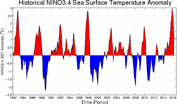
Entering the winter of 2015-16, the El Niño had fully matured into a basin-wide event, boasting sea surface temperature anomalies of more than +3°C at times. Its prominence drew comparisons to ancestors including the 1997-98 El Niño, and both events reached nearly identical strength at their peak according to most indices.
Its strength helped the El Niño defy expectations during the winter of 2015-16. The ongoing active southerly jet stream helped cut down any developing ridging over the western US. That largely prevented cold air from funneling into the southeast, even with support from El Nino’s distant atmospheric cousin, the polar vortex. Although North Carolina had its fourth-wettest winter on record, the state saw below-normal seasonal snowfall.
By the end of the winter, an insidious bubble of cold water beneath the Pacific Ocean’s surface began creeping eastward and eroding the El Niño. This fight meant some of its atmospheric effects shut down during the spring, with North Carolina switching to a drier pattern in March and April.
As vital signs continued to fade, sea surface temperature anomalies in the central Pacific finally flatlined at zero late last month. At this point, the El Niño was pronounced dead at its home in the middle of the ocean. It is survived by a residual pool of warm water on either side of the equator and potentially a step-sister arriving this fall in the form of a developing La Niña.
Friends and family thank the trade winds for their support in El Niño’s development and the coast of South America for setting boundaries on its eastward extent. In lieu of sending flowers, you may subscribe to the Climate Blog or follow us on Twitter for ongoing updates about global patterns and North Carolina’s climate.