After record-setting rainfall early in the month, seasonable high temperatures took over for the rest of October.

Seasonable Temperatures Reign
After leaving the 80s and 90s behind in September, we kept high temperatures in the 60s and 70s for most of October, making for fall-like afternoons across the state. In Rocky Mount, the average high of 70.4°F ranks as the 8th-coolest October in the past 114 years.
However, those seasonable highs were balanced by warm low temperatures thanks to plenty of cloudy evenings. That resulted in mean temperatures about 1.5°F above normal. The statewide mean temperature of 60.87°F made it our 40th-warmest October in the past 121 years.
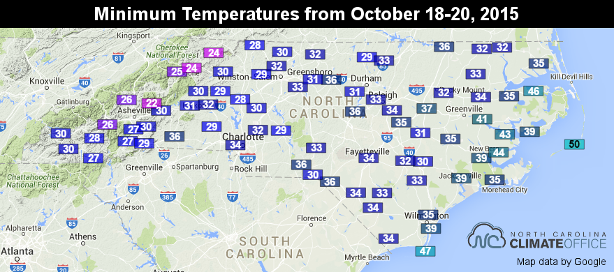
Not all nights were on the warm side, though. Consecutive cool evenings from October 18 to 20 brought the first frost of the season to most of the state and the first fall freeze to parts of western North Carolina.
Record Rainfall Fuels Our Wettest October
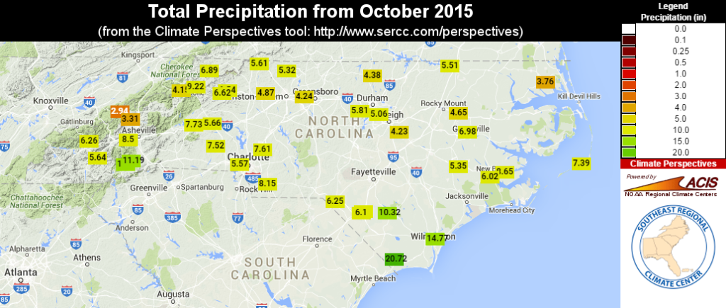
Thanks to one of North Carolina’s wettest weeks on record early in the month and more rain in the final week, October’s statewide average precipitation of 9.30 inches ranks as the wettest October since 1895, easily besting the second-wettest total of 8.61 inches from October 1971.
Several weather stations near the South Carolina border reported much higher totals than the statewide average. Along the southern coast, Longwood in Brunswick County received 20.72 inches of rain and Wilmington had 14.77 inches last month. In the southern mountains in Transylvania County, Brevard received 12.77 inches and the Pisgah Forest station had 11.19 inches.
Last month also joins some elite company among our state’s overall wettest months. The preliminary statistics put October 2015 as North Carolina’s 15th-wettest month on record. It ranks just behind June 1995, when the state was soaked from the remnants of Hurricane Opal, and July 2013, when western North Carolina saw heavy rain, flooding, and landslides amid one of its wettest summers on record.
Our wet start to October wiped out all drought conditions and recent dryness across the state. In a single week, the southwestern Piedmont improved by three categories on the US Drought Monitor, going from Severe Drought (D2) to nothing. The last time such a rapid improvement happened in North Carolina was after Hurricane Floyd in 1999.
Recent Rain and Frost Impact Agriculture
The growing season wound down in October, but not without some weather intervention from the early-month rains and the mid-month frost and freeze.
County extension agents reported that the heavy rain delayed their harvest and caused crop losses of 10 to 20 percent, particularly to tobacco, cotton, and sweet potatoes. The rain did help alleviate dryness in pastures, particularly in the drought stricken western Piedmont counties.
Growers in the northern Piedmont said that the frost ended tobacco and summer vegetable growth. Winter wheat growth is now beginning with nearly ideal soil conditions in place.
As our recent blog post detailed, October’s weather also affected the emergence of fall leaf colors. While the early-month rain delayed the color change a bit, several weeks of fall-like weather helped the colors reach a vibrant peak across much of the state.