Once upon a time last month, our temperatures seemed bland and boring, but a closer look revealed a world of precipitation possibilities, including snow, soggy spots, and the return of dryness in North Carolina.
Goldilocks-Like Temperatures
In terms of temperatures, January was like the baby bear’s porridge: not too hot, not too cold. It was indeed an unremarkable month as far as the mercury goes.
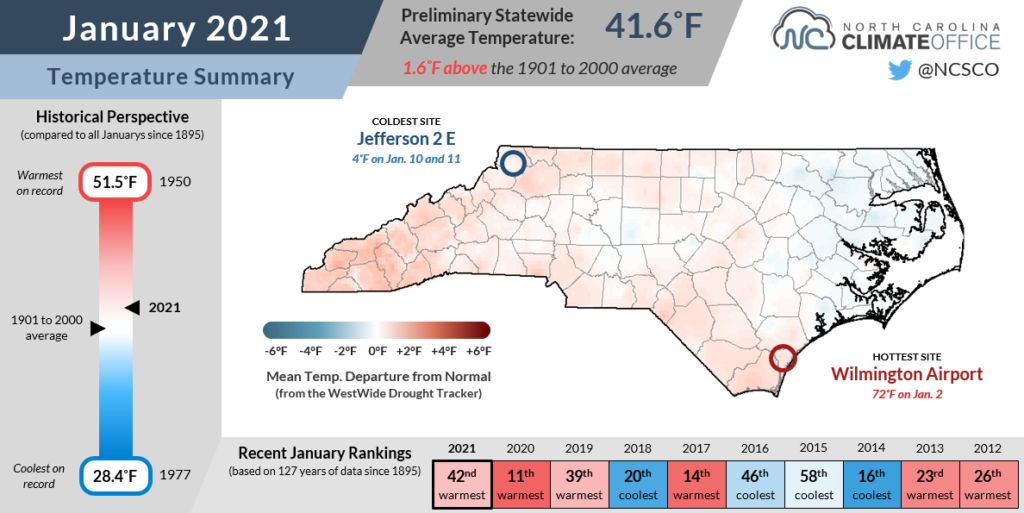
According to the National Centers for Environmental Information, the preliminary statewide average temperature last month was 41.6°F, which ranks as our 42nd-warmest January since 1895.
That mean temperature was slightly above normal, but nowhere close to our warm January in 2020 in which our average temperatures were more than 6 degrees above normal and included a stretch of days with highs in the 70s.

By comparison, last month was much more moderate. Our high temperatures were mostly confined to the 40s and 50s with few extremes beyond that. In fact, Raleigh, Fayetteville, and Elizabeth City each reached the 60-degree mark only one time in the entire month.
At the same time, no sites outside of the higher elevations in the Mountains recorded highs below freezing all month. Even in Asheville, temperatures made it above the freezing mark every day this January, while last year, the highs there were below freezing twice amid an otherwise warm month.
Our nighttime lows were fairly mild as well, and our average minimum temperature of 32.0°F ranks as our 36th-warmest January on record. Hickory never dropped below 20 degrees all month, and has only been that cold twice so far this winter. The average low temperature of 30.3°F in Danbury ranked as the 9th-warmest January there since 1959 based on minimum temperatures.
Snow White and the Seven-Year Drought
Wintry weather — or the lack thereof — last month surely left some in the state Happy and some Sleepy, while others were just Grumpy after another month without any snow.
January did have several frozen precipitation events, but as is often the case in North Carolina, temperatures proved to be a deciding factor between areas that received snow, ice, and just plain rain.
The first event of note on January 8 saw 2 to 4 inches fall in the Mountains with a dusting across parts of the northern and western Piedmont.
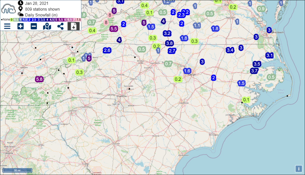
Later in the month on January 28, a lucky few were again off to the (snow) ball. This time, the glass slippers fit the northern Coastal Plain, which picked up the greatest totals as cold air was in place when the bulk of the moisture arrived.
Parts of Granville and Vance counties received 5 inches or more per CoCoRaHS observations, while 2 to 3 inches fell from Greenville northward to Roanoke Rapids, and the Triangle received an inch or two.

The month ended with a mixed precipitation event including freezing rain in our northern counties on January 31. While temperatures at the surface hovered around freezing throughout the day, the carriage of cold air in the lower atmosphere turned into a pumpkin just north of the Virginia border, so snow melted and fell as rain across North Carolina.
Even as sites such as Plymouth (3.7 inches of snow last month), Edenton (3.5 inches), and Elizabeth City (3.1 inches) have exceeded their normal annual snowfall thanks to that January 28 event, other parts of the state went yet another winter month without any significant snowfall.
Charlotte measured only a Tom Thumb-sized 0.1 inches of snow last month. The last event with at least an inch of snow there was more than two years ago in December 2018.
While snow isn’t as common in Wilmington, the Port City hasn’t seen snow since January 3-4, 2018, when 3.8 inches fell.
One of the longest snow droughts in the state belongs to Fayetteville, which hasn’t had any measurable snow since January 2018, and hasn’t seen more than an inch since 3 inches fell on January 29, 2014, now more than seven years ago.
Soaked Beanstalks and Developing Dryness
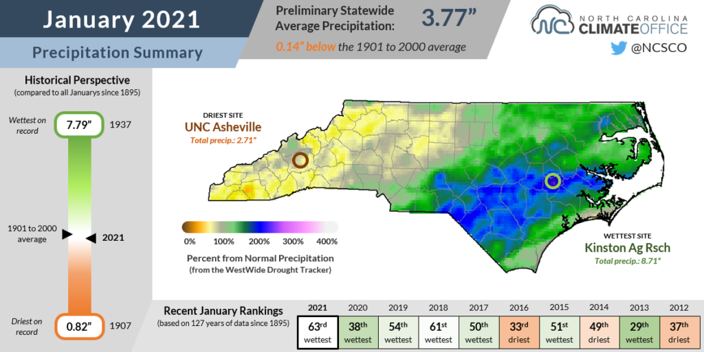
While NCEI reports a preliminary statewide average precipitation of 3.77 inches, or our 63rd-wettest January out of the past 127 years, it was a month in which the variability across the state isn’t well-captured by a single number.
For the Coastal Plain, it was another wet month thanks to low pressure systems that routinely tracked up the east coast. Lumberton and Ocracoke were each 3.1 inches above normal, while Fayetteville was 2.1 inches above normal and tied for its 10th-wettest January since 1899.
The continuing wet weather in eastern North Carolina has been a frustration for farmers. Some soybeans have yet to be harvested, and small grains such as wheat and barley may see reduced yields since fields have been too wet to apply fertilizer.

The Piedmont is as close to a Goldilocks region for precipitation as you’ll find in the state. Greensboro finished the month just 0.3 inches above normal, and Charlotte was 0.6 inches above normal in January. Even after a drier two-week stretch in the middle of the month, reservoirs and streamflows remain near their typical seasonal levels across central North Carolina.
Finally, not to get too Grimm, but some drier spots have recently emerged in the Mountains. Dating back to November, Murphy in Cherokee County is 5.3 inches below its normal precipitation, and January was 1.5 inches below normal.
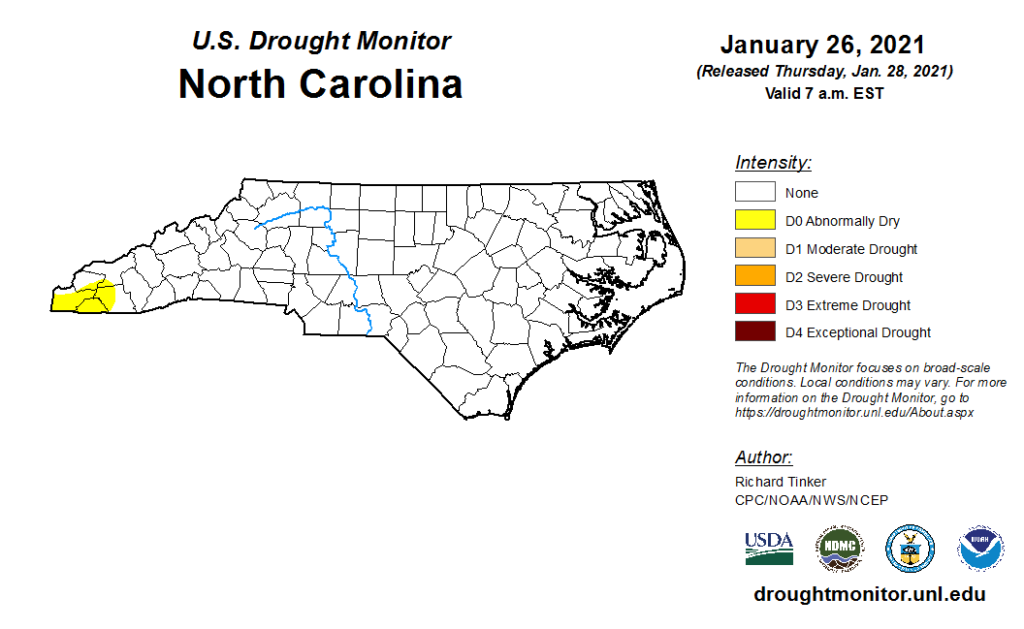
As a result, portions of five counties in the far western Mountains are now classified as Abnormally Dry on the US Drought Monitor, mainly due to those deficits and the first impacts appearing in January such as declining groundwater levels.

Fortunately, that isolated area is the extent of our dryness two months into the winter, which some feared would be cursed with drought under the spell of the wicked stepmother La Niña. But like Hansel and Gretel, we’re not out of the woods just yet.
Our February weather, including whether we warm up and dry out or fall into a wetter and more wintry pattern, may determine whether we’re facing fallow fields, flooding, or living happily ever after heading into the spring.