For the ninth year in a row, we’re proud to share our winter outlook for North Carolina. This year, the atmosphere has offered up a clear indication of the main large-scale pattern at play entering the winter: a fast-forming La Niña during in the fall.
The El Niño-Southern Oscillation (ENSO) is one of the most closely correlated global climate patterns with our cool-season weather in North Carolina. When the ENSO phase is obvious, it removes some uncertainty in the forecast like we had last year, when ENSO-neutral conditions gave us few clues about our likely winter weather.
This year, a fairly mature La Niña event is already in place, so the main questions you might have are How strong is it?, What does La Niña mean for us?, Will drought develop? and What will the winter look like in NC?
ENSO Conditions and Forecast
Throughout the fall, we’ve seen a dramatic cooling of sea surface temperatures across the equatorial Pacific Ocean. With average sea surface temperature anomalies set to be below -0.5°C for the third consecutive three-month average period in November, that means we’re already in a La Niña phase, and a fairly well-developed one at that.
As NOAA’s ENSO Blog notes, the October average sea surface temperature anomaly in the main monitoring region was 1.3°C below normal, or the eighth most negative October value since 1950.
We’re also seeing the atmospheric effects of those cooler sea surface temperatures. With fewer clouds over the central Pacific during the La Niña event, the outgoing longwave radiation — or heat energy escaping from earth’s surface back to space — has increased across that region.
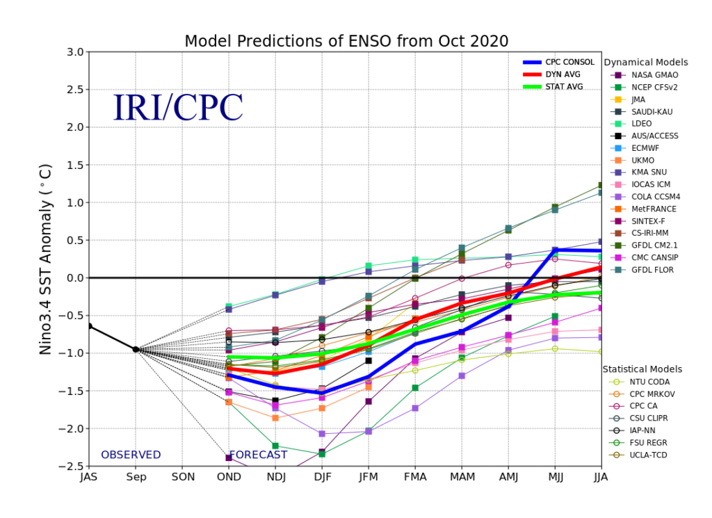
Most climate forecast models show sea surface temperature anomalies leveling off through the winter, while a few others suggest a bit of additional cooling may occur. Either way, that’s likely to put us in a moderate or borderline strong La Niña this winter. (The threshold for strong events is generally around 1.5°C below normal.)
Around 90% of models do show La Niña conditions in place this winter, and more than half expect it may linger through the early spring. That means we may be living with La Niña and its impacts for several months. Speaking of which…
La Niña’s Effects in NC
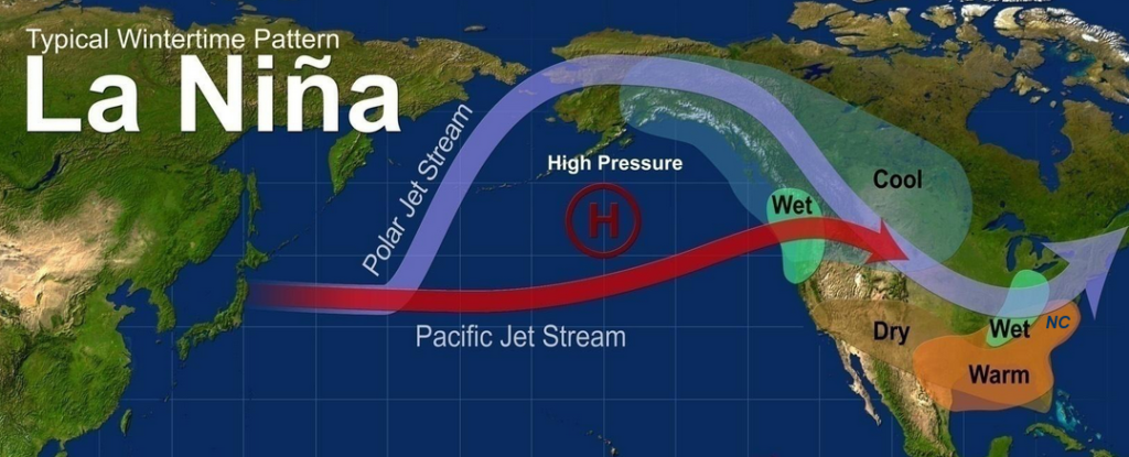
As with El Niño events, La Niña can affect our prevailing weather in North Carolina by changing the strength and position of the northern hemisphere jet stream pattern. The cooler water near the equator cools the air above it, and that relatively small temperature difference between the equator and the North Pole tends to make the jet streams weaker and wavier.
Instead of having a strong jet stream anchored to our south and routinely pushing low pressure systems through the Gulf of Mexico like we often see in El Niño winters, the jet streams often retreat to the north in La Niña winters.
Without as many storm systems tracking along our coast or over our state, that tends to make La Niña winters drier than normal across the Southeast US, including in North Carolina. That pattern also tends to bring in warmer air from the south, so in many La Niña events, we have above-normal wintertime temperatures, on average.
That’s not to say that we can’t see cold air and even snow in a La Niña winter. Those big events are a bit less likely, but they can happen. For example, in January 2018 — in a La Niña phase slightly weaker than what we’re expecting this year — there were two significant snows in eastern and central North Carolina.
More commonly, though, our wintry events are lighter and less frequent in La Niña years. With fewer low-pressure systems throwing in moisture off the Atlantic, we can see more clipper-type storms that bring limited precipitation and mostly light snow in northern and western parts of the state.
That was the case in 2011-12, which had only one snow event of note in mid-February. That winter, Asheville received only a trace of snow — the least snowy winter there since at least 1888.
Doubts About Drought?
Dry winter weather can cause problems in the early spring, including insufficient soil moisture for planting, limited recharge of reservoirs, and vegetation drying out to yield a bad fire season.
Some past moderate La Niña winters have seen drought persist or worsen across the state, including in 2010-11 and 2017-18. But both of those winters — and many other past La Niña winters in North Carolina, as it turns out — were preceded by a dry summer or fall, so we started the winter season with moisture deficits.
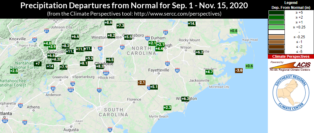
We’re in the opposite position this year, especially after the heavy rainfall across the state last week. Most areas are anywhere from 2 to 14(!) inches above their normal precipitation for the fall so far, and both soil moisture and streamflow levels remain well above normal.
It was also wet leading into the winter of 1995-96, and even though it was our 41st-driest winter on record with 1.5 inches less precipitation than normal, we entered the spring with near-normal or slightly wet conditions persisting, both in our drought indicators and in streamflow levels.
That gives us hope that if or when our weather pattern becomes a bit drier, we could withstand a few dry months without too many significant springtime impacts.
The Winter Outlook
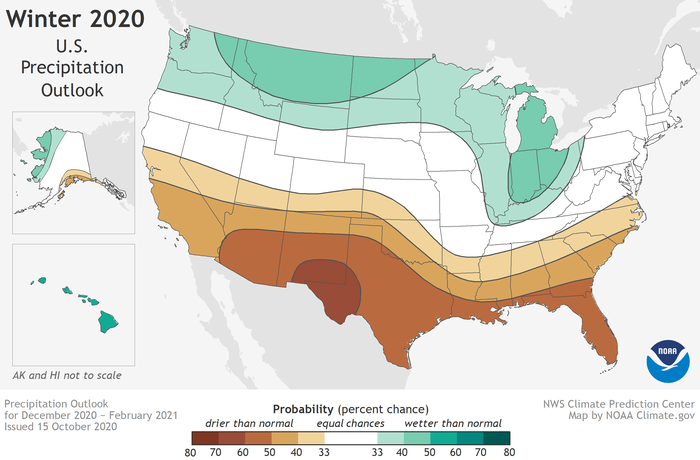
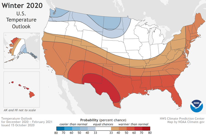
Last month, NOAA released its temperature and precipitation outlooks for the winter, and they closely reflect the typical La Niña conditions. That includes increased chances of warm and dry weather across most of the southern tier of the US, and wetter conditions possible across the Ohio Valley and Great Lakes states, which the storm track tends to favor in La Niña winters.
It’s important to note that their forecast isn’t a guarantee of a warm, dry winter. For North Carolina, their outlook calls for a 33 to 40% chance of below-normal precipitation and a 40 to 50% chance of above-normal temperatures.
In other words, there are elevated odds of being warm or dry, but still plenty of chance that it won’t be, at least for the entire season. Past moderate La Niña winters like in 1995-96 and 2010-11 were relatively cool, and in 1970-71, our wintertime precipitation was near-normal.
With that in mind, we do expect that La Niña will be the primary driver of our winter pattern. Some years in our outlook, we discuss other atmospheric indicators of possible wintertime conditions, but none of those has as much predictability or as strong of a relationship with our weather and climate as ENSO.
Certainly, a weakening and southward-diving polar vortex could bring cooler weather and snow chances, but we caution that such an event is difficult to forecast with any confidence this far in advance.
Looking even further into the future, what might the spring look like? As long as conditions aren’t exceedingly dry this winter, we should enter the spring with sufficient topsoil moisture and water supply levels, similar to the 1995-96 winter.
One thing to watch for is a potential February warm-up or “false spring” — a stretch of warmer weather before the last freeze. Each of our past four Februarys in North Carolina has ranked among the top 11 warmest on record, and the odds of that happening in 2021 are even higher given the La Niña pattern.
If it does happen again, we could see increasing evapotranspiration and some emerging dryness late in the winter, potentially persisting into the spring if La Niña sticks around that long.
In summary, we have high confidence that the current La Niña event will remain through the winter, and expect La Niña-like conditions — namely, warmer and drier weather — through at least part of the winter in North Carolina. However, recent rainfall across the state has given us a moisture surplus and should help us weather the winter, even if it dries out a bit.