Summer 2014 Was Mild; What Will Fall Bring?
We avoided a sweltering summer in North Carolina, but what do the numbers say about the season? Today’s post summarizes our summer, looks at current conditions, and forecasts what we may see this fall.
Summer Recap
The end of August meant the end of meteorological summer*. The three-month period from June through August finished as the 21st-coolest and 53rd-driest out of the past 120 years in North Carolina. That made it our coolest summer since 1997.
* If you’re curious, check out this graphic from the National Weather Service office in Kansas City explaining why meteorological seasons are different from astronomical seasons.
| Year | Wilmington | Raleigh | Charlotte | Greensboro | Asheville |
|---|---|---|---|---|---|
| Historical avg. | 36.5 | 38.8 | 39.7 | 32.6 | 9.9 |
| 2014 | 44 | 37 | 32 | 23 | 1 |
| 2013 | 18 | 24 | 15 | 11 | 1 |
| 2012 | 43 | 48 | 45 | 37 | 12 |
| 2011 | 57 | 67 | 70 | 49 | 23 |
| 2010 | 58 | 75 | 69 | 55 | 19 |
June was on the warm side, especially in eastern North Carolina, but July and August both had mean temperatures well below normal thanks to regular troughiness in the jet stream over the eastern U.S. Many weather stations finished the summer with average mean temperatures ranked in their all-time top 15s, including top-ten rankings at long-term stations in Statesville, Concord, and Tarboro.
The cool mean temperatures were largely driven by cooler-than-normal maximum temperatures. Outside of the southern coast, most of the state has seen no more than a few dozen days at or above 90°F through the end of August. As the table to the right shows, we have spent a little more time above 90° than we did last year, but this year has been a relief compared to the heat we had in 2010, 2011, and 2012.
The lack of significant heat also meant relatively good air quality all summer. In fact, there were no Code Orange or higher days observed in North Carolina for the first time since ozone measurements started being recorded in 1990. For more information about air quality in North Carolina, check out last month’s guest blog posts from the NC Division of Air Quality describing the basics of air quality forecasting and a case study from a poor air quality event two years ago.
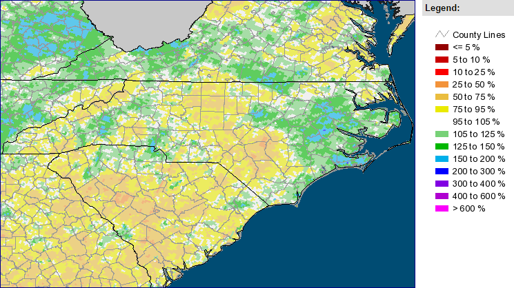
The statewide average suggests near-normal precipitation, but not everyone saw regular rainfall this summer. Some parts of the Triad and the Sandhills saw only half of their normal summertime rainfall, which led to their “Abnormally Dry” classification by the US Drought Monitor. Meanwhile, several heavy rain events put the western Piedmont, Charlotte, and the Triangle on the wet side of normal.
Much of the coast also saw above-normal precipitation. That was partially thanks to Hurricane Arthur, which made landfall near Beaufort on July 3rd. Along with heavy rains, Arthur brought hurricane-force winds to the coast and spawned the summer’s only three confirmed tornadoes in North Carolina.
Current Global Conditions
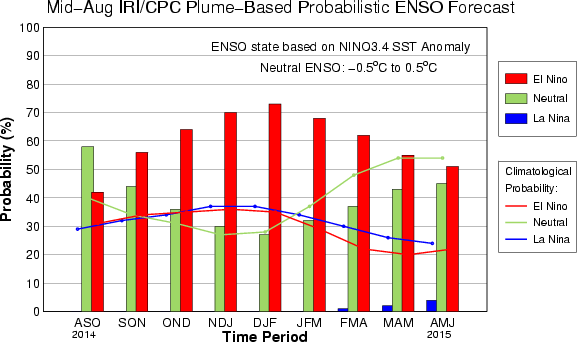
Since the early spring, we have been closely monitoring conditions in the equatorial Pacific Ocean. Several months ago, it seemed almost certain that an El Niño event would emerge this summer. While sea surface temperatures in the eastern Pacific have been above normal, the overall pattern doesn’t exactly show typical El Niño conditions.
As NOAA’s ENSO blog nicely explains, we haven’t seen the strong west-to-east gradient in sea surface temperatures (SSTs) that causes a change in the wind patterns: the atmospheric response to El Niño’s oceanic manifestation. The latest conditions continue to lack this gradient in SST anomalies. However, a sub-surface wave of warmer water similar to the one we saw in April has been moving eastward, which could rejuvenate a developing El Niño event.
As the graph to the left shows, a little over 70% of climate models continue to predict El Niño conditions — SSTs at least 0.5°C above normal — by the winter. We should know with more certainty as the fall continues and the evolution of conditions in the Pacific becomes more clear.
In the Atlantic, the tropical season has been off to a slow start. As we approach the climatological peak of the season around September 10th, we have seen just four named storms — the fewest to that point in the season since 1994. Atlantic SSTs have recently warmed, but continuing wind shear of up to 50 knots in the main development region has played a role in the lack of activity.
In the north Atlantic, another ongoing event could shape conditions across Europe in the coming months. The Bardarbunga volcano in Iceland has been active since mid-August, and the Iceland Met Office has noted “escalating unrest with increased potential for eruption”. The last major volcanic eruption in Iceland — from Eyjafjallajökull in 2011 — was not large enough to have a noticeable impact on global temperatures, but its ash cloud did impact thousands of flights as it was carried by the jet stream across Europe.
It’s too early to say when or if Bardarbunga might erupt and what its impacts could be, but it’s worth monitoring over the next few months, especially if you have potential travel plans to or from Europe.
Fall Outlook
September is off to a warm start, and the Climate Prediction Center’s three-month temperature outlook expects a warmer-than-normal fall for the US east coast. That prediction seems to be driven mostly by the recent warmth and the latest climate model forecasts. Their fall precipitation forecast suggests an equal chance of wetter-than-normal or drier-than-normal rainfall.
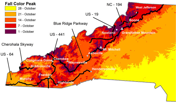
One fall highlight in North Carolina is the leaves changing color. While the peak of fall colors often doesn’t occur until late October for most of the state, parts of the mountains begin hitting their peak color in early October. The latest Fall Color Report from Appalachian State University notes that some trees in the western part of the state are beginning to show some changing colors.
Thanks to near-normal rainfall across the state this summer, we shouldn’t see too many dried-out leaves falling from trees before they hit their peak color. That should give some great autumnal arboreal sights throughout the next few months.
- Categories:


