This is the final part of our 2013-14 winter outlook series, which includes our official winter outlook based on clues from global climate patterns. This post is by Bradley McLamb, a State Climate Office alumnus and meteorologist at the North Carolina Division of Air Quality.
El Niño/Southern Oscillation
Computer model guidance has been very consistent this fall in predicting near-neutral ENSO conditions to continue during the upcoming winter. This will be the second consecutive neutral ENSO winter, and as we discussed last fall, this again means that the equatorial Pacific Ocean will have no significant impacts on the winter pattern of the continental U.S.
With one of the most reliable indicators of winter conditions remaining silent, we’ll have to look elsewhere for clues on how the winter may unfold for the Tarheel State.
Siberian Snowfall
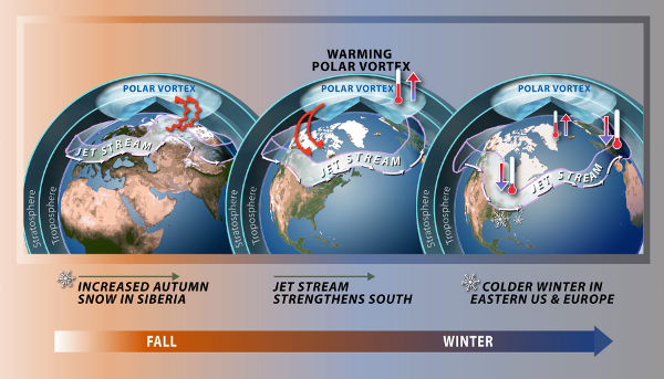
Previously, we introduced the concept of using October Siberian snowfall as a tool in predicting North Carolina winter weather. The idea is that when snow cover rapidly increases in Eurasia during the fall, important changes to the atmosphere occur that can shape the predominant jet stream pattern across the eastern United States during the following winter months.
Last year, we noted the rapid rise in October Siberian snow cover could have foreshadowed negative phases of both the Arctic and North Atlantic Oscillation for the upcoming winter. However, this prediction didn’t entirely pan out. Despite being predominantly negative for much of last winter, the AO was never able to substantially weaken the polar vortex for an extended period. Thus, it wasn’t able to disrupt the jet stream pattern to the extent needed to cause a major pattern change, including a negative NAO. So while the Siberian snowfall theory was effective in predicting a negative AO last winter, it didn’t have the expected impacts on NC winter weather.
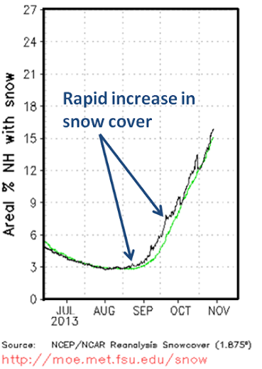
Now to the fun part — looking ahead to winter 2013-14! In regards to Siberian snowfall this fall, there’s a bit more uncertainty than last year. The reason is that the Siberian snowfall theory is based on the rate of October snow cover increase, but this fall saw a significant rise in Eurasian snow cover (as seen in the figure on the left) from mid-September through early October. It is difficult to tell if an earlier start to the rapid rise in snow cover will have similar effects on the large scale weather pattern, including the AO and NAO.
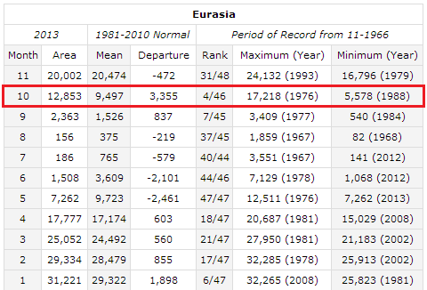
However, if we assume that the researched correlation between Siberian snowfall in October holds for mid-September, we can speculate about the upcoming winter pattern for NC. Eurasian snow cover for October 2013 ranked 4th out of 46 years. Again, the caveat is that much of this snow fell during the last two weeks of September, but nonetheless the amount of snow cover on the ground in October 2013 in Eurasia was impressive.
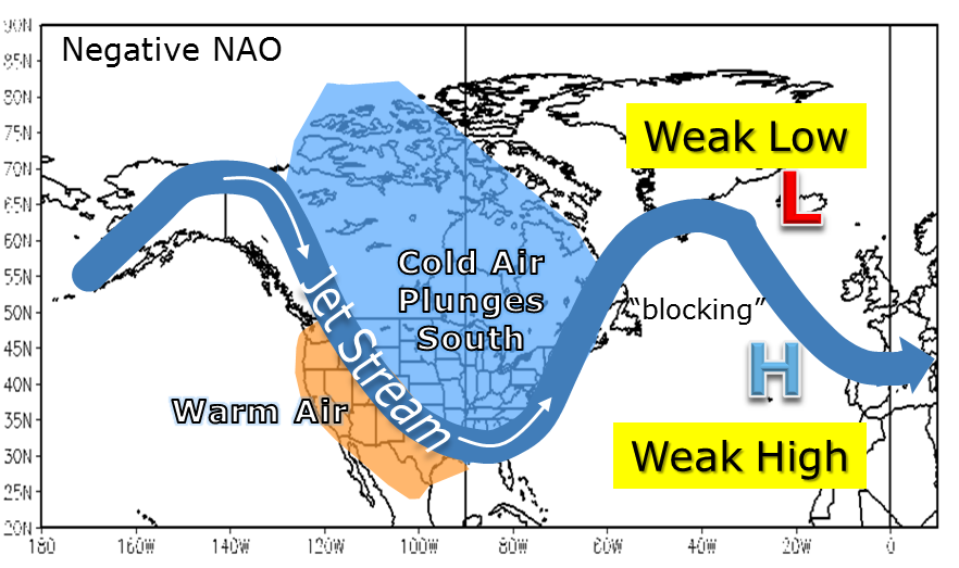
If the Siberian snowfall theory holds, then the AO may predominantly be in the negative phase during the upcoming winter. Often, this is a precursor to the NAO also going negative, although last winter served as a prime example that this isn’t always the case. With that said, if both the AO and NAO are predominantly negative this winter, then several bouts of cold and possibly wintry weather may occur.
Our Winter Outlook
In the short term, the latest computer models suggest that through the rest of December, we’re probably going to experience a continuation of the variable temperatures seen thus far.
Although there aren’t currently any strong indications of a favorable pattern for prolonged cold weather or snow in North Carolina, such as a negative-phase NAO or positive-phase PNA, if it’s going to happen this winter, the next 4 to 6 weeks may be the most likely time to see these develop based on the effects of the early-season buildup of snowfall over Siberia. If that happens, it would likely be another 1 to 2 weeks before the Southeast felt the effects. Based on the current modeling, the Siberian snowfall, and our winter climatology, we may have our best opportunities to see a cold, wintry pattern from mid-January to mid-February.
Overall, the lack of any large-scale forcings from ENSO means this winter will likely be similar to last year’s, with a mix of cooler and milder periods throughout the season along with regular precipitation and at least one or two chances of seeing measurable snow for most of the state. Any sustained favorable changes to the jet stream pattern, such as negative NAO and/or positive PNA events, would allow us to tap into the cold air that has already set up to our north, and it might bring additional chances of receiving wintry precipitation. Stay tuned to the blog throughout the winter for updates!