This is part four in a four-part series highlighting different winter forecasting techniques.
Each year as summer turns to fall, folks begin to wonder: “What will this winter be like?”
When seasonal forecasters attempt to answer this, there are few indicators that provide them with clues as to what the weather will be like for the next several months. The most frequently analyzed “clue” is the El Niño/Southern Oscillation (ENSO), a naturally occurring phenomenon that involves oscillating sea surface temperatures (SSTs) in the equatorial Pacific Ocean.
The basic concept behind ENSO is that warmer water in the central and eastern equatorial Pacific Ocean sloshes, or oscillates, back and forth, much like water in a bathtub. SSTs fluctuate from warmer than normal (El Niño) to cooler than normal (La Niña). There is also a neutral phase when SSTs are near normal.
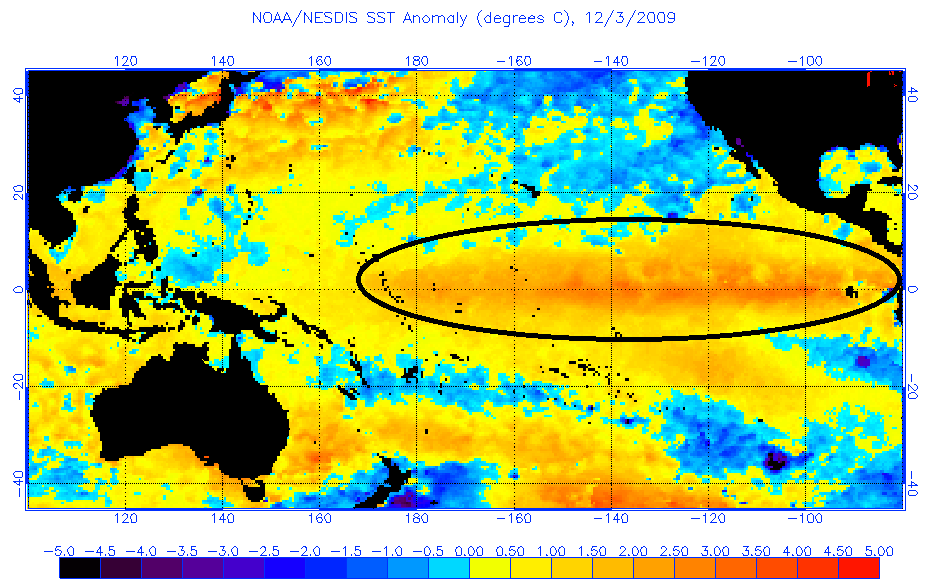
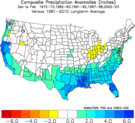
El Niño is responsible for weaker low-level atmospheric winds along the equator and enhanced convection (thunderstorm activity) across the entire equatorial Pacific due to warmer ocean temperatures. Increased equatorial convection strengthens the subtropical jet stream, enhancing storminess across the southern U.S. The end result is enhanced wintertime precipitation in North Carolina.
La Niña conditions produce the opposite effects of El Niño. Low-level atmospheric winds along the equator are stronger, and convection across the entire equatorial Pacific region is reduced. This leads to a weaker subtropical jet stream, and below-average winter precipitation in North Carolina.
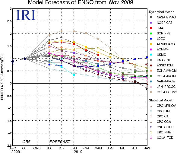
So how can ENSO be used to predict winter conditions in the U.S.? Computer models offer guidance on the evolution of ENSO. Forecasters run an ensemble of computer models to simulate ENSO conditions for the coming months. When a large majority of the models predict that a particular ENSO phase (El Niño or La Niña) is going to occur through the winter, meteorologists gain confidence in predicting the associated precipitation patterns of that ENSO phase.
As discussed in part 3 of our series, the Arctic and North Atlantic Oscillation (AO and NAO) play a more direct role in day-to-day weather conditions across the eastern U.S., and when the negative phase of these patterns develop in an El Niño winter, the probability for winter weather in North Carolina is at it’s highest. The easiest way to think about it is that the AO and NAO are responsible for delivering the cold air, while El Niño provides the storm system via the more active subtropical jet stream — thus, you have all of the ingredients needed for wintry weather!
ENSO alone doesn’t determine what type of winter North Carolina will experience, but it’s seasonal influences are well-understood and predictable enough to enhance confidence when attempting to answer the age-old question: “What will this winter be like?”