This is part three in a four-part series highlighting different winter forecasting techniques.
Can forecasting North Carolina winter weather be improved by measuring snowfall in Siberia? A group of scientists believe it can by helping to improve the forecasts of two of the most important large-scale climate patterns that affect each winter in the eastern United States – the Arctic and North Atlantic Oscillations (AO and NAO, respectively).
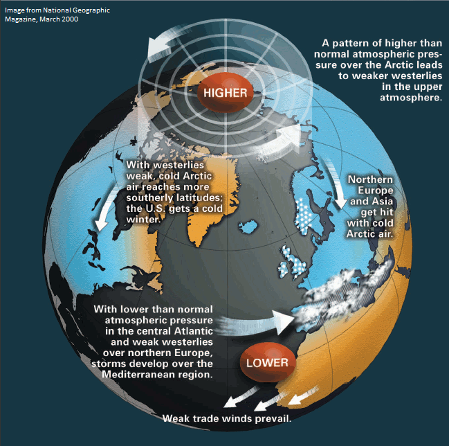
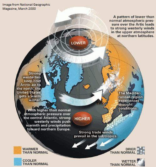
The AO and NAO are both essentially measures of the strength of the polar jet stream, just in different locations (AO over the North Pole, NAO over the Icelandic region). Each index consists of a negative and positive phase.
When the AO/NAO are in the negative phase, semi-permanent polar circulations that define the strength and position of the polar jet stream are weaker than normal (pressures are higher), which results in the polar jet stream winds being slower. When this happens, cold Arctic air forces the polar jet stream to buckle southward, allowing the cold air to push into the eastern United States.
Despite their importance, the AO and NAO are considered “wildcard factors” in most seasonal forecasts because they are generally unpredictable beyond two weeks — the current limit of reliable computer model output. However, a new seasonal forecasting tool — the Snow Advance Index, developed by researchers at Atmospheric and Environmental Research (AER) — promises to improve upon this forecasting limitation dramatically.
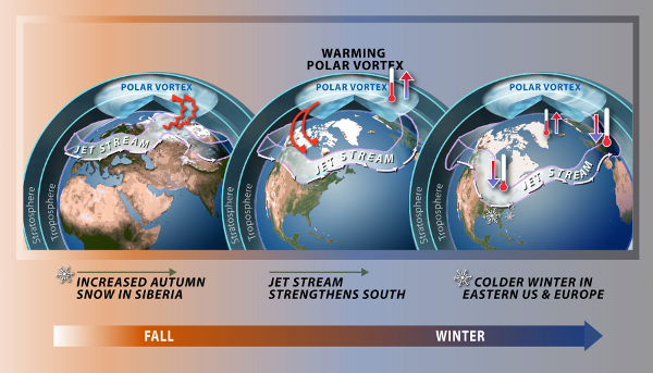
AER’s research proposes that when Siberian snow cover quickly increases in October, the AO and NAO are more likely to be negative for a majority of the following winter. The Snow Advance Index also considers a number of other factors such as global sea surface temperatures, upper atmospheric temperatures, the El Niño/Southern Oscillation, and large-scale atmospheric waves.
The basic idea behind the Siberian snowfall theory is that intense, high-latitude snow storms in October result in cooling at the surface and warming in the upper atmosphere — a recipe for weakening the polar vortex (and ultimately the AO/NAO). The reason the polar vortex weakens under this scenario is because vortices derive strength from large temperature gradients between the Earth’s surface and higher up in the atmosphere. Snow cover cools the surface, and the energy responsible for producing the snow releases heat higher aloft in the atmosphere, which significantly reduces the temperature gradient and removes the energy the polar vortex needs to strengthen.
So how have seasonal forecasts based on AER’s new Snow Advance Index performed? The short answer is pretty well, at least for the period they have been analyzed. Last winter, AER forecasters predicted a well-above-normal temperature regime across the eastern U.S. for the entire winter, and this verified extremely well. They also correctly predicted the cold and snowy winter of 2009-2010 for our region.
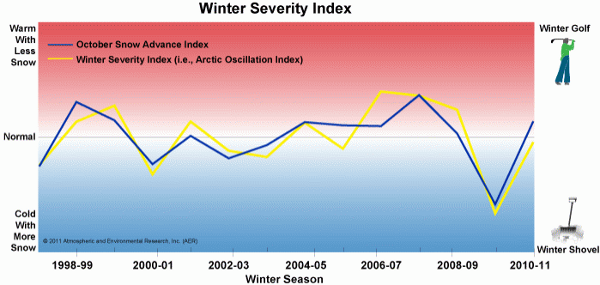
The one caveat here is that this method has only been evaluated for winters since 1998-99, so the possibility exists that it might not perform as well every winter as it has with some of the most recent ones. Still, there appears to be a strong likelihood that some degree of correlation exists between the rate of October snow cover increase in Siberia and the dominant phase of the AO/NAO in winter.
So, the next time North Carolina is in the midst of a cold and snowy winter, its origin may trace back to snowfall that occurred thousands of miles away in October!
Sources:
- Siberian snowfall may help improve U.S. weather forecasts from the Washington Post
- Snow Advance Index: A New Tool for Predicting Winter’s Severity from AER.com
- Predicting Seasonal Weather from a National Science Foundation special report
- Putting a Siberian Snow Connection to the Test from the New York Times