Winter 2012-13 Recap
Back in December, we released our winter outlook that included our own winter forecast and the predictions of the woolly worm, farmers’ almanacs, and two important global climate patterns. A little over three months later, the winter has now wrapped up, giving us a chance to review the winter and these predictions.
ENSO’s Impacts (or Lack Thereof)
In our outlook, we speculated that the El Nino/Southern Oscillation (ENSO), which is often one of the best indicators of our wintertime conditions in North Carolina, would remain in a neutral phase and therefore play little role in shaping our winter conditions. As the winter evolved, sea surface temperatures in the equatorial Pacific Ocean became slightly cooler than normal, and depending on the metric used to measure the ENSO conditions, the winter averaged either cool neutral or very weak La Nina conditions.
One way to assess the impact of ENSO on North Carolina winters is by checking the effects on our temperature and precipitation. El Nino winters are typically cool and wet; for example, the 2009-10 winter was the 11th coldest and 5th wettest on record for North Carolina. La Nina winters are typically warm and dry, such as the 2011-12 winter, which was the 12th warmest and 9th driest.
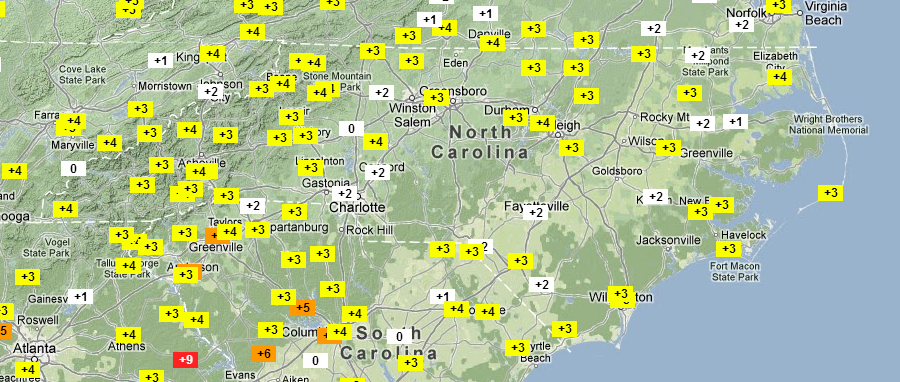
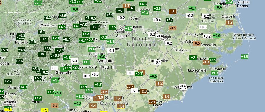
This winter did not fit either pattern: the three-month December, January and February period was the 19th warmest and 28th wettest on record for North Carolina. As the maps below show, most of the state saw mean temperatures 2 to 4 degrees above normal, on average, with near-normal rainfall except in the mountains, which were particularly wet.
Other Climate Patterns
We also discussed how October Siberian snowfall could impact the Arctic Oscillation (AO), and documented that October 2012 was the 11th snowiest in the last 45 years in Siberia. This suggested that a predominantly negative phase of the Arctic Oscillation could be in store for the winter. That prediction verified well — the AO was in the negative phase for the majority of the winter, and continues to run negative currently.
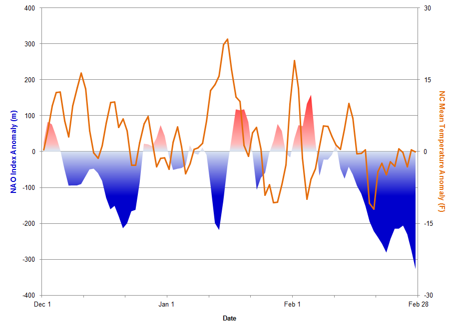
Unfortunately for winter weather lovers, the North Atlantic Oscillation (NAO), which is more directly correlated to eastern U.S. weather, never followed suit. As evidenced by the figure below, for most of the December through February period, the NAO measured within 100 meters of neutral (average), which essentially means that conditions in the north Atlantic were normal and the flow pattern over the eastern U.S. was not being affected. The lack of influence from the NAO helps explain why North Carolina never saw extended periods of unusually warm or cold weather this winter.
In our mid-winter pattern update, we introduced the Pacific/North American Pattern (PNA) and discussed how it influenced our mild start to the winter. From late December through early January, the PNA did briefly transition into the positive phase, which suggests troughing and below-normal temperatures in the eastern U.S. However, our research has shown that the NAO — not the PNA — provides the most direct impact on eastern U.S. weather, and with the NAO remaining near-neutral to slightly positive during this period, the short-lived positive PNA pattern was unable to deliver any sustained cold or wintry weather to North Carolina.
The winter of 2012-13 was exceptional in only one way: the minimal contribution from any major global climate pattern (ENSO, NAO, PNA). With such little large-scale influence, the winter was unsurprisingly dominated by benign weather. We experienced several relatively low-impact winter weather events. However, all of these events were plagued in one way or another — too warm or very little moisture — by the lack of a truly favorable winter weather pattern, which from a climate pattern perspective consists of a negative phase NAO combined with a positive phase PNA. Without these favorable patterns in place, it is truly rare — and very difficult — to get the timing and availability of cold air and moisture to come together in the way needed to create a high-impact winter storm outside of the higher terrain of the state.
Forecast Review
Our forecast for the 2012-13 winter was for a cooler, slightly snowier winter than we had in 2011-12. Neither was too tough to beat considering the 2011-12 winter was the 12th warmest statewide with only one minor snow event across most of the state. The final numbers show that we were, in fact, cooler this winter than the previous year, but only by about one degree on average, and most of the state saw only slightly more snow than last year.
Here are some specifics from weather stations around the state:
- Raleigh had its 10th warmest winter on record, with 1.5 inches of snow observed at the Raleigh-Durham Airport. Last year was the 3rd warmest with only 0.9 inches of snow.
- Greensboro had its 14th warmest winter on record with 4 inches of snow, most of which came during a rare thundersnow event in January. Last year was the 4th warmest on record with 1.6 inches of snow.
- In Charlotte, this winter was the 11th warmest with 2 inches of snow, compared to the 8th warmest with a trace of snow last year.
- Wilmington saw its 12th warmest winter on record this year with a trace of snow. Last winter was the 9th warmest with no snow observed.
- Asheville had its 9th warmest winter this year with a surprisingly low 0.2 inches of snow. Last winter was the 3rd warmest on record with no measurable snow.
Snow lovers in Asheville may be suffering more than anyone else in the state: For a location that averages more than 9 inches of snow per year, it has been more than two years — since mid-January 2011 — that more than an inch of snow fell there.
Other Forecasts
Another forecast we featured in our outlook was made by a caterpillar at Banner Elk’s annual Woolly Worm Festival in October. This year’s woolly worm predictions called for a cold, snowy start in December, becoming mild by late January, finishing with cool, wintry conditions in mid-March. Looking back, December was actually fairly warm while late January saw below-normal temperatures. Mid-March was cool but featured no snow and ice. All in all, this year’s woolly worm predictions did not seem to pan out. Tough luck for the most recent polypedal champ.
We also highlighted the predictions from two farmers’ almanacs that are supposedly based on secret formulas involving astronomical cycles and historical conditions. Both almanacs struggled to correctly predict this winter’s conditions, though. The Old Farmer’s Almanac was off on its predictions for below-normal winter temperatures and precipitation and near- or above-normal snowfall. It did correctly call for cold periods in early and mid-February. The Farmers’ Almanac called for wet and chilly conditions across the southeast, which was partially correct — it was wetter than normal, but not cooler than normal. Overall, though, the warm winter threw these publications and their well-guarded formulas for a loop.
- Categories:


