Reflecting on a Record-Setting, Storm-Soaked September
Due to Hurricane Helene, the National Centers for Environmental Information’s data center in Asheville is currently shut down. Our colleagues at NCEI have confirmed that all of their staff are safe and accounted for in the wake of the storm. Since the preliminary statistics and statewide rankings are unavailable, our monthly climate summary for September will have a different format than usual.
It was a September to remember for all the wrong reasons in North Carolina, as two soaking storms on either end of the state delivered historic rainfall totals and flooding.
While the month also featured a number of comparatively minor events, including an early-month frontal passage that dropped more than 3 inches of rain in parts of the Triangle, this September will ultimately be defined by its two significant events.
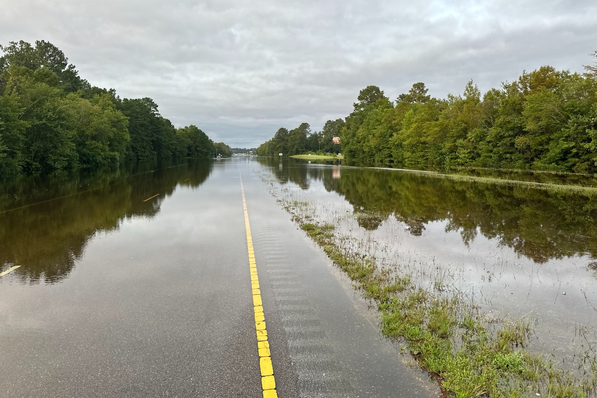
On September 14, low pressure developing offshore began streaming in moisture along our southern coastline. Over the next four days, more than 15 inches fell in southern Brunswick and New Hanover counties, which left several feet of standing water in the streets of Carolina Beach and washed over roadways farther inland.
While never classified as a named tropical storm, Potential Tropical Cyclone Eight rivaled some of the wettest events on record in places like Southport and Bald Head Island, all just six weeks after the same areas picked up nearly a foot of rain from Tropical Storm Debby.

On September 25, a frontal boundary stalled across the Mountains and aligned perfectly with the Blue Ridge to funnel saturated air up the slopes. As Hurricane Helene approached from the south, it flung in tropical moisture along that boundary, then its remnants tracked directly over western North Carolina to wrap up an historically wet and destructive three-day event.
Local totals exceeded 12 inches throughout the Mountains, with more than 20 inches – and up to 31.33 inches at a weather station in Busick – inundating rivers and communities across the region. That resulted in record-breaking river crests, road-closing mudslides, and life-threatening flooding.
While this may not go down as our wettest September on record statewide – the monthly average of 13.22 inches in 1999, which featured two hard-hitting hurricanes, will be tough to top – it could be the most impactful, and unfortunately, the most deadly.
As of October 2, the death toll from Helene stands 73, including 61 in Buncombe County alone, and those numbers are expected to rise further as damage assessment continues. Power remains out for more than 340,000 customers in the state and widespread road closures are still in effect, with officials recommending only emergency travel.
Throughout the cleanup and recovery process, the North Carolina Disaster Relief Fund remains the best way to support affected communities. Relief is now reaching areas in need by plane, by truck, and even by mule, but the road to complete recovery will surely be a long one given the scale of the damage.

Local Rankings and Records
September finished with above-normal rainfall across all but the northeastern corner of the state, and the wettest areas received three to four times their normal monthly totals.
With 13.02 inches, it was the 3rd-wettest September on record in Raleigh, while the 9.49 inches in Charlotte made it the 5th-wettest September there. Among other Piedmont and coastal sites, it was the 3rd-wettest September for Ocracoke with 11.48 inches and the wettest September on record since 1952 in Lincolnton, with 10.72 inches.
Although some western stations are still offline due to the widespread power and communications outages since Helene, the sites we do have data for in that area have unsurprisingly reported one of their wettest Septembers – if not their all-time wettest month – on record.
Starting in the north, Sparta had 24.27 inches to easily surpass the 19.74 inches in September 2004 and record its new wettest month on record dating back to 1942. Boone recorded 23.01 inches all month – nearly 40% of its annual average – in the 2nd-wettest September on record there.
Our ECONet station on Mount Mitchell had its record wettest month since 2008 with 35.80 inches in total. Among our ECONet, we also saw record high monthly precipitation totals on Bearwallow Mountain (26.57 inches), Sassafras Mountain (20.93 inches), Fletcher (19.08 inches), and Spindale (15.51 inches).
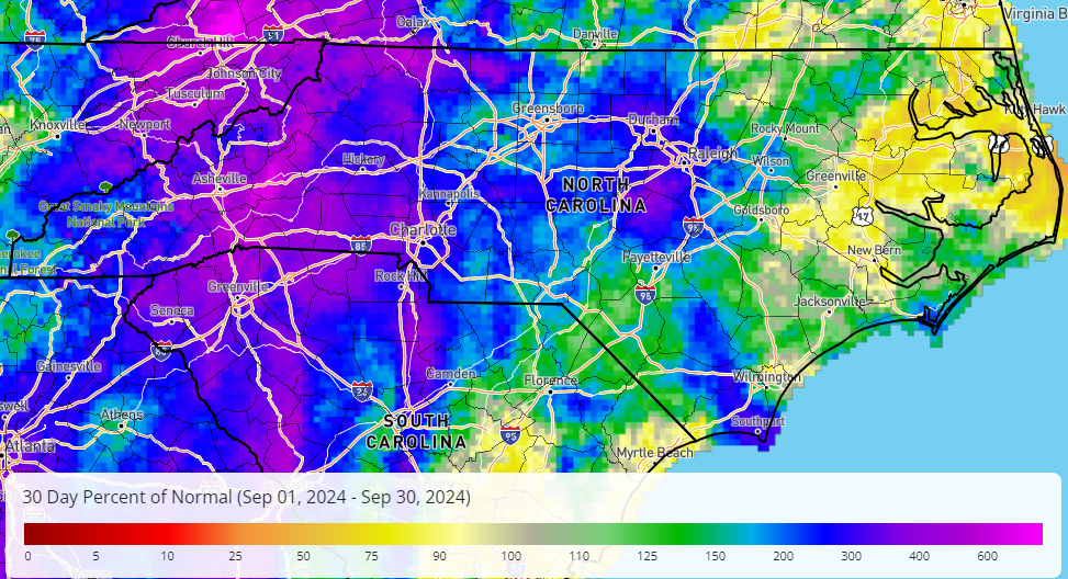
Asheville’s official observing site at the airport had 17.90 inches, making this September its wettest month on record dating back to 1869. Almost 14 inches of that rain came over three days before and during Helene.
West of Asheville, the rainfall totals from Helene were lower, but they still picked up at least 7 inches during that event and saw crests to moderate or major flood stage on the Tuckasegee and Pigeon rivers.
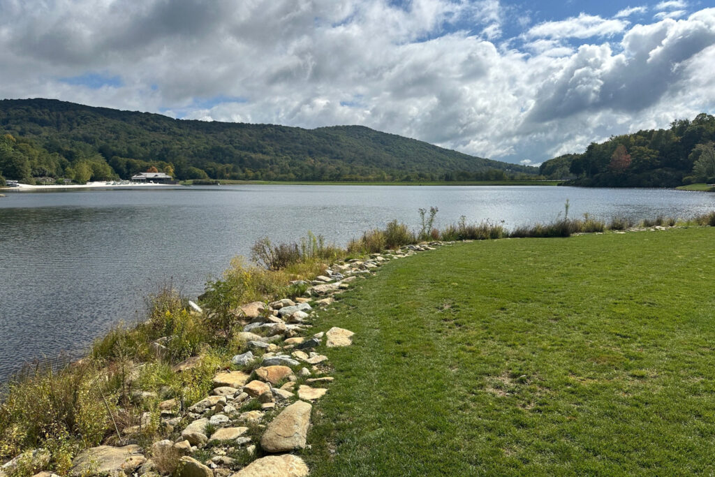
Needless to say, that heavy rain was more than enough to eliminate the Severe Drought conditions that had been in place prior to Helene. Fontana Lake had been up to 7 feet below its target levels coming into the fall, but it saw a nearly 15-foot rise during the storm and is now well above its normal seasonal elevation.
Compared to our precipitation, last month’s temperatures were relatively unremarkable, as most areas finished with monthly averages within 2 degrees of normal. It was the 19th-warmest September on record for Hickory since 1949, tied for the 23rd-warmest in Raleigh, and tied for the 35th-warmest in Charlotte, Fayetteville, and Elizabeth City.
We did get a brief taste of fall early in the month as a crisp high pressure system to our north dropped morning lows into the 50s on September 10 and 11, with some 40s even observed throughout the Mountains. In Boone, the first 40°F reading of the season on September 10 happened 12 days earlier than average, and nearly a month earlier than last year’s first night that cool on October 8.
This Month in History
Either of the extreme precipitation events would have made for a notable month on its own, but having two such events in the same month was downright historic.
This is the first month on record in North Carolina in which two separate events each produced more than 20 inches of rain in part of the state. That includes only the second event in the state’s recorded history in which precipitation totals exceeded 30 inches locally, joining Hurricane Florence from 2018.
Both of this month’s storms joined a small but growing list of recent extreme precipitation events in which parts of the state have seen at least 18 inches of rainfall. Only in September 1999 — with the back-to-back hits from Dennis and Floyd — have we previously had two such events in a single month.
Prior to 1999, such extreme rainfall totals were almost unheard of in North Carolina. The Weather Prediction Center’s archive of tropical events includes only one other storm with at least 18 inches of rain in our state: the mid-August hurricane in 1940. The July 1916 storm, which produced more than 22 inches in 24 hours at Altapass, may be the only other historical event of that magnitude with accurately measured totals.
| Event | Date Range | Maximum Rainfall in NC |
|---|---|---|
| Hurricane Dennis | Aug. 29 to Sep. 5, 1999 | 19.91” (Ocracoke) |
| Hurricane Floyd | Sep. 14 to 16, 1999 | 24.06” (Southport) |
| Hurricane Frances | Sep. 6 to 9, 2004 | 23.57” (Mount Mitchell) |
| Coastal Frontal Event | Sep. 26 to 30, 2010 | 22.54” (Wilmington) |
| Upper-Level Event | Sep. 29 to Oct. 5, 2015 | 18.23” (Longwood) |
| Hurricane Matthew | Oct. 8 to 9, 2016 | 18.95” (Evergreen) |
| Hurricane Florence | Sep. 13 to 17, 2018 | 35.93” (Elizabethtown) |
| Potential TC Eight | Sep. 14 to 17, 2024 | 20.81” (Carolina Beach) |
| Hurricane Helene | Sep. 25 to 27, 2024 | 31.33” (Busick) |
That makes nine such events in the past 26 years, not counting close calls such as Hurricane Ivan (17.00 inches at Cruso in 2004), Hurricane Ophelia (17.50 inches at Oak Island in 2005), or Tropical Storm Fred (14.00 inches on Frying Pan Mountain in 2021).
It’s no coincidence that these extreme events are becoming both more common and more intense. The North Carolina Climate Science Report, released in 2020, previewed that it’s “very likely that extreme precipitation frequency and intensity in North Carolina will increase due to increases in atmospheric water vapor content.”
While it’s too early to say exactly how much worse climate change made the rain and flooding from PTC8 or Helene — and those studies have been done for storms like Florence — the environment in which both storms developed bears the hallmarks of climate change, including record warm sea surface temperatures in the Gulf of Mexico and the humid atmosphere that allowed them to send ample moisture in our direction.
We hope we’ll never have another month like September 2024 again, but as the odds of these extreme, impactful storms continue to increase, we also hope our state will rebuild smarter, stronger, and safer in anticipation of whatever comes next.
- Categories:


