Winter 2012-13 Pattern Update
To this point, the winter in 2012-13 has shown some potential for sending cold and wintry weather to North Carolina but has largely failed to deliver. The potential has been in the form of a persistent, moderately negative Arctic Oscillation (AO) for the past two months. Unfortunately for cold misers, the North Atlantic Oscillation (NAO), which is more directly correlated to eastern U.S. weather, has not followed suit to the same degree.
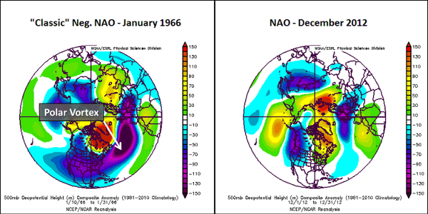
While the NAO was negative at times during the month of December, it was often by definition only. The semi-permanent Icelandic low pressure system was displaced for much of the past month, which is the primary indicator of a negative phase of the NAO.
However, since the beginning of December the large-scale atmospheric pattern has primarily been void of another important feature of a typical negative NAO phase — namely, a displaced polar vortex near southeastern Canada/Newfoundland (see figure below), which is responsible for delivering cold, Arctic air southward — thus limiting its influence on eastern U.S. weather to a large extent.
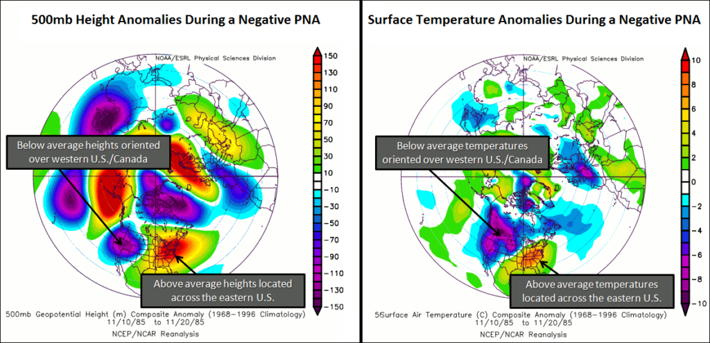
In addition to the shortcomings of the NAO, another climate pattern has also been working against the negative AO to prevent wintry weather from invading the eastern U.S. It is known as the Pacific/North American (PNA) pattern, and it too was in the negative phase for most of December — but in the case of the PNA, that is a warm signal for the eastern U.S.
As the figure below shows, a negative phase PNA features troughing and below normal geopotential heights (an estimation of pressure surfaces, with lower heights resulting from cold, dense air) and temperatures over the western U.S., and ridging with above normal geopotential heights and temperatures over the eastern U.S.
So, where does winter go from here? We can start by looking back at analog years – past years that featured very similar atmospheric conditions to the current one – and studying how they turned out. Analyzing the El Niño/Southern Oscillation (ENSO), NAO, and PNA for December 2012, we found December 1990 to be the best analog. From a temperature perspective, December 2012 had a statewide average temperature of 47.9°F, the 8th warmest December on record, just ahead of December 1990, which came in at 47.8°F.
The next logical question to ask is — how did the winter of 1990-91 turn out? If you’re a snow lover, you might want to turn away. The winter of 1990-91 ended up being one of only six winters on record at the Raleigh-Durham International Airport that featured only a trace of snowfall for the entire winter season. Furthermore, we can’t find records of any significant winter storms across the entire state during that winter.
Looking ahead to the rest of this winter, indications are that a “January thaw” will take hold for at least the next week, after which it is really anyone’s guess where the AO/NAO/PNA will take us. However, after an entire month of moderately negative AO values failed to deliver any sustained cold or wintry weather to the eastern U.S., it is apparent that a significant pattern alteration will be needed (specifically to the PNA and NAO), and the winter clock is ticking.
But don’t lose all hope, winter lovers! Even if we never establish a sustained cold pattern, winter storms can still occur — often at a moment’s notice — which is what makes forecasting/researching/experiencing winter weather so much fun in North Carolina!
- Categories:


