On our table in November, our cup didn’t exactly runneth over as dry weather continued, but it was a fittingly fall-like month – aside from an early bite of winter with a mid-month snow event.
Dry Turkey: Another Precipitation Deviation
Rain didn’t have a regular place at the table again last month, which was drier than normal across North Carolina. Based on preliminary data from the National Centers for Environmental Information (NCEI), the statewide average precipitation was 1.18 inches, which was our 16th-driest November since 1895.
Much of the Mountains, Piedmont, and Sandhills had less than an inch of total precipitation all month. That included Asheville with 0.66 inches and its 13th-driest November on record, 0.52 inches in Greensboro in its 9th-driest November, Fayetteville’s 0.55 inches for its 8th-driest November on record, Charlotte’s 0.49 inches and 8th-driest November.
Coastal areas fared a bit better, largely due to the impact of an offshore low pressure system on November 3. On that date, Hatteras had 5.21 inches of rain – its wettest single day since August 31, 2023, during Tropical Storm Idalia. With a final monthly total of 7.33 inches, it was the 14th-wettest November for Hatteras, while Elizabeth City had 3.79 inches and its 27th-wettest November on record.
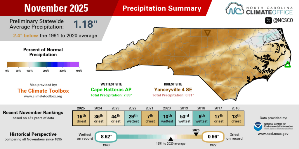
For inland areas, though, there were very few notable rain events throughout the month. Before it emerged offshore, the low pressure system crossing the state on November 2 brought around half an inch across most of eastern North Carolina, and a warm front moving through on November 21 brought widespread but light rain generally totaling a half-inch or less.
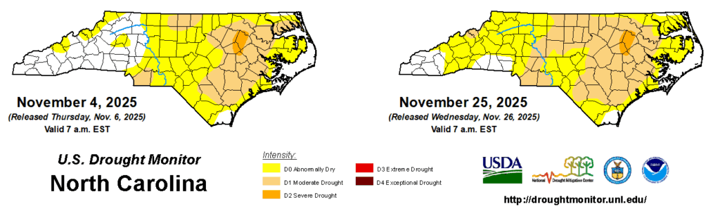
Our dry November wrapped up an overall dry and drought-plagued fall for most of the state. Near the epicenter of the current spot of Severe Drought (D2) in the northern Coastal Plain, Greenville had 6.01 inches of rain – just 42% of its normal amount – all season for its 10th-driest fall on record.
In the Piedmont, where Moderate Drought (D1) expanded in November, Raleigh had its 13th-driest fall dating back to 1887, and Monroe tied for its 10th-driest fall on record out of the past 125 years.
Among our recent drought impacts, streamflow levels continued to decline in November, Falls and Jordan lakes fell more than two feet below their targets, and on a few dry and windy days, wildfire activity flared up, including a 160-acre fire burning near Banner Elk and a 500-acre fire on the Roanoke River National Wildlife Refuge.
Lukewarm Leftovers: Another Weakly Warm Month
Continuing another trend from this fall, November saw mostly near-normal to slightly above-normal temperatures statewide. NCEI reports a preliminary average temperature of 52.2°F and our 28th-warmest November out of the past 131 years.
Many eastern sites finished within a degree of their normal monthly temperature, including Wilmington tying for its 58th-warmest November in the past 150 years and Lumberton tied for its 39th-warmest November on record.
Central and western areas were 2 to 4 degrees above normal, on average, including the 16th-warmest November on record for Charlotte, the 25th-warmest for Greensboro, and tied for the 29th-warmest in Raleigh.

In contrast to recent years when we saw multiple 80-degree days in November 2023 and 2024, that sort of warmth had waned by last month. Instead, with weaker high pressure across the Southeast, our warmest days topped out in the mid-70s, and a series of cold frontal passages meant even that warm weather was short-lived.
Those fronts also ushered in some downright cold air, especially in an Arctic blast on November 11 that brought widespread below-freezing temperatures, officially ending the growing season across most of the state.
That morning’s low of 31°F in Wilmington was the earliest sub-freezing day there since 1998, and Laurinburg’s low of 26°F was its coldest night that early in the season since 1991.
Another chill arrived just in time for Thanksgiving, including widespread lows in the upper 10s and low 20s on Saturday, November 29. Our Goldsboro ECONet station bottomed out at 20°F – one of only six November nights that cold there in the past 24 years.
Icing on the Cake: A Snowy Surprise
Clearly there was no tryptophan slowing winter’s arrival last month, and it showed with more than just a few chilly nights. Along the cold front that ushered in that frigid air on November 11, precipitation fell as snow, with flakes observed from the Mountains all the way to the coastline.
The highest totals naturally fell on our highest elevation areas, including parts of the Great Smoky Mountains that had more than six inches, plus 3 inches in both Hot Springs and Grandfather Mountain.
Banner Elk had 2.5 inches, which was its earliest snow of that size since 2014. In recent years, it took until mid-January in both 2023 and 2024 to see that much snow in a single day.
While November snow in the Mountains isn’t too rare, it was unusual to see accumulations much farther east. Isolated areas south of the Albemarle Sound had up to 2 inches, with a widespread dusting to half an inch of snow.
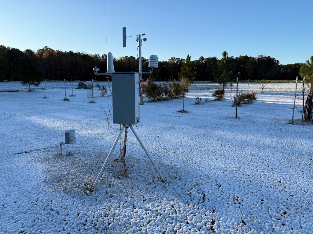
Edenton reported 0.2 inches on the ground in its earliest measurable snow on record dating back to 1895. Williamston and Plymouth each measured 0.3 inches, which was also their earliest snowfall in a season – and in Williamston, it happened almost two full weeks earlier than the previous record, which was set in 1935.
While it’s tempting to hope that this November snow is a sign of things to come throughout the winter, it’s important to keep expectations in check. Another recent early-season snow in December 2018 turned out to be essentially the only snow most areas saw in that entire winter.
And as our winter outlook noted, the La Niña pattern in place this winter is often warmer and drier than normal in North Carolina, and we expect below-normal snowfall overall. Our best chances of snow will likely look like that November event: narrow windows of time when cold air is in place and any passing weather systems bring enough moisture to fuel some flakes.
With climatological winter officially underway, we now await whatever the weather serves up next, whether it’s more dry dishes, something fire-roasted amid an extended drought, or perhaps a trip to the freezer for another cold and frozen surprise.