
April featured unseasonable warmth and an uncharacteristic lack of rain showers and severe weather. That has extended our drought with new impacts emerging last month.
A Summer-Like Warm-Up
With above-normal temperatures night and day for most of the month, this finished among our warmest Aprils on record in North Carolina. The National Centers for Environmental Information (NCEI) reports a preliminary statewide average temperature of 63.0°F and our 2nd-warmest April since 1895.
In both Charlotte and Raleigh, it ranked as the warmest April on record, surpassing our warm but wet April in 2017. Asheville also had its warmest April locally dating back 134 years.
At other long-term weather stations, it was the 2nd-warmest April for Fayetteville, Greenville, and Greensboro; tied for the 3rd-warmest in Elizabeth City; the 4th-warmest April for Hickory; and the 5th-warmest in Wilmington.
While our average high temperatures in early April are in the upper 60s, we were pushing 90 degrees in the first week of April this year under the control of a broad upper-level high pressure system.
Raleigh did top out at 90°F on April 4, which was its fifth-earliest first 90-degree day on record, and the earliest in a calendar year since 1990. Hot Springs was one of our hottest spots last month, hitting 91°F on April 5 in its second-earliest day that warm since 1984.
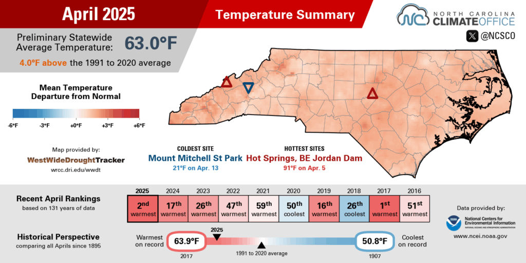
The second week of the month saw a few cooler nights, including sub-freezing temperatures in some northern and western areas on April 9. That morning’s low of 31°F in Henderson was its final freeze of the spring, which happened about a week earlier than the average date of April 15.
By April 19, our high temperatures were back into the 80s as a surface high pressure system set up off our coast. Even on Easter Sunday, the sunrise temperatures in the low 60s were more typical of late May or early June.
That warmth was tough to escape in the final days of the month Between April 19 and 28, Raleigh logged nine consecutive days with temperatures of at least 80°F – its 4th-longest streak of April days that warm, and the longest since 1985.
With so many warm days and so few cool nights, plants remained in full bloom – and in full pollen production – throughout the month. While recent pollen levels have remained high, the top contributors to that pollen count have shifted from pine trees and their dusty yellow spores to other species such as oak and birch trees.
Your allergies may not notice the difference yet, but it’s at least a sign that this prolonged pollen season is progressing, with tree pollen levels likely to wind down throughout May.

Limited Rain and Storms
The April showers we usually expect were less common last month, leaving most of the state drier than normal. NCEI notes a preliminary statewide average precipitation of 3.02 inches, which ranks as the 42nd-driest April out of the past 131 years.
Much of eastern North Carolina totalled less than two inches of rain all month, including just 1.37 inches in Plymouth during its 6th-driest April on record and 1.50 inches in Fayetteville for its 15th-driest April dating back to 1910.
The Piedmont was mostly near or slightly below their normal precipitation. Raleigh finished 0.14 inches above normal, while Greensboro was 0.89 inches below normal and Charlotte was 1.32 inches below normal in its 57th-driest April out of the past 146 years.
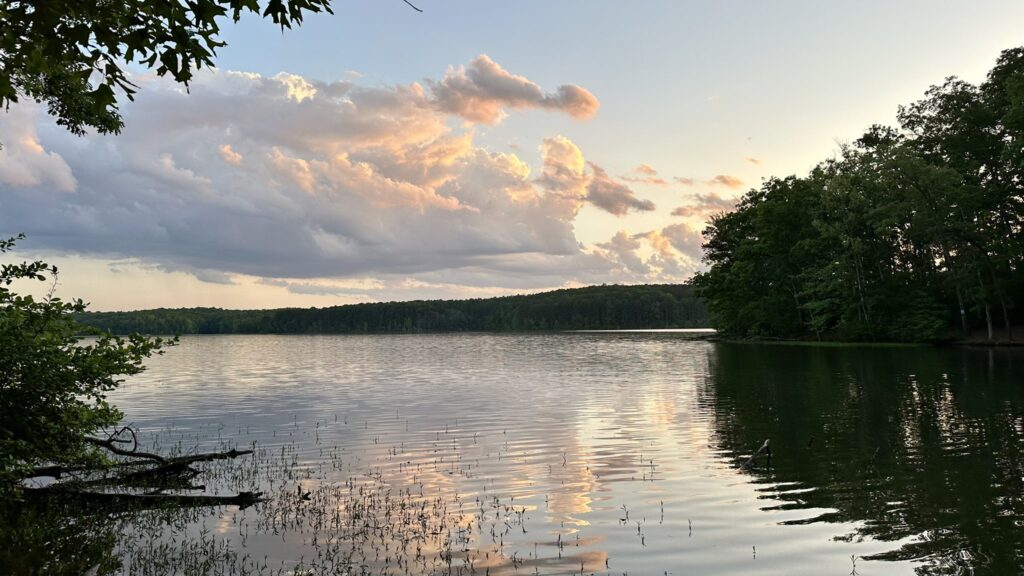
Our one consistently wet region last month was the southern Mountains, which got in on several heavier rain events such as a frontal system to our west on April 6 and local rain showers on the fringes of high pressure on April 25 that kept the rest of the state dry.
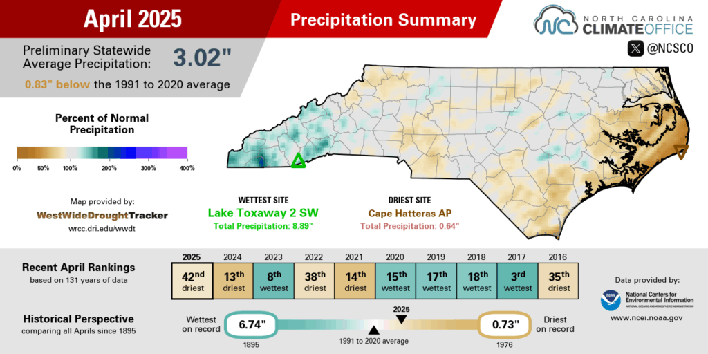
Asheville was 0.47 inches above normal and tied for its 28th-wettest April on record. Pisgah Forest was 0.93 inches above normal in its 23rd-wettest April since 1940. And Highlands lived up to its status as one of our typical wettest locations with 8.62 inches of rain in total, which was 1.64 inches above normal and its 30th-wettest April out of 120 years with observations.
The same high-pressure pattern that kept us so warm also helped block springtime cold fronts from moving in. That led to a rare lack of severe weather during one of our climatologically most active months.
For the first time since 2022 and only the second time in the past eight years, there were no tornadoes across the state this April, and only a smattering of large hail and high wind reports, such as those across the central Piedmont on April 22.
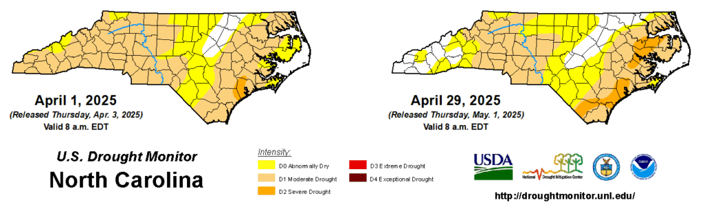
While the late-month rain brought some local drought improvement in far western North Carolina, drought conditions lingered elsewhere and Severe Drought expanded in parts of the Coastal Plain, prolonging the drought that has now been present for more than six months in some of those eastern areas.
Assessing Our Ongoing Drought
While this may not feel like a long-lived drought, particularly since its impacts were muted over the winter, by one measure this is now our longest-lasting drought in more than 15 years.
At least one-third of the state has been classified in some category of drought on the US Drought Monitor since December 3 – a span of 22 consecutive weeks. The last time drought was that widespread for that long of a time was in 2007-08 as part of a 79-week streak during one of our state’s worst drought events.
We’re a long way from matching that event, both in duration and intensity, but we are feeling the effects of the current drought now that we’ve entered our warm season. Here’s a roundup of the current impacts and how those might evolve over the next month or two:
Rainfall Deficits
Outlook: partial recovery possible beginning in May
Since this drought’s fall emergence, the statewide precipitation deficits over the past six months range from 5 to 15 inches. At the driest sites in or near the Severe Drought zone, both Longwood (at 12.54 inches below normal) and Washington (15.21 inches below normal) just finished their driest November-through-April period on record.
We won’t erase fully those deficits with a single rain event or even a single wet month, but we could chip away at them, and the forecast is favorable for that in the coming weeks and months.
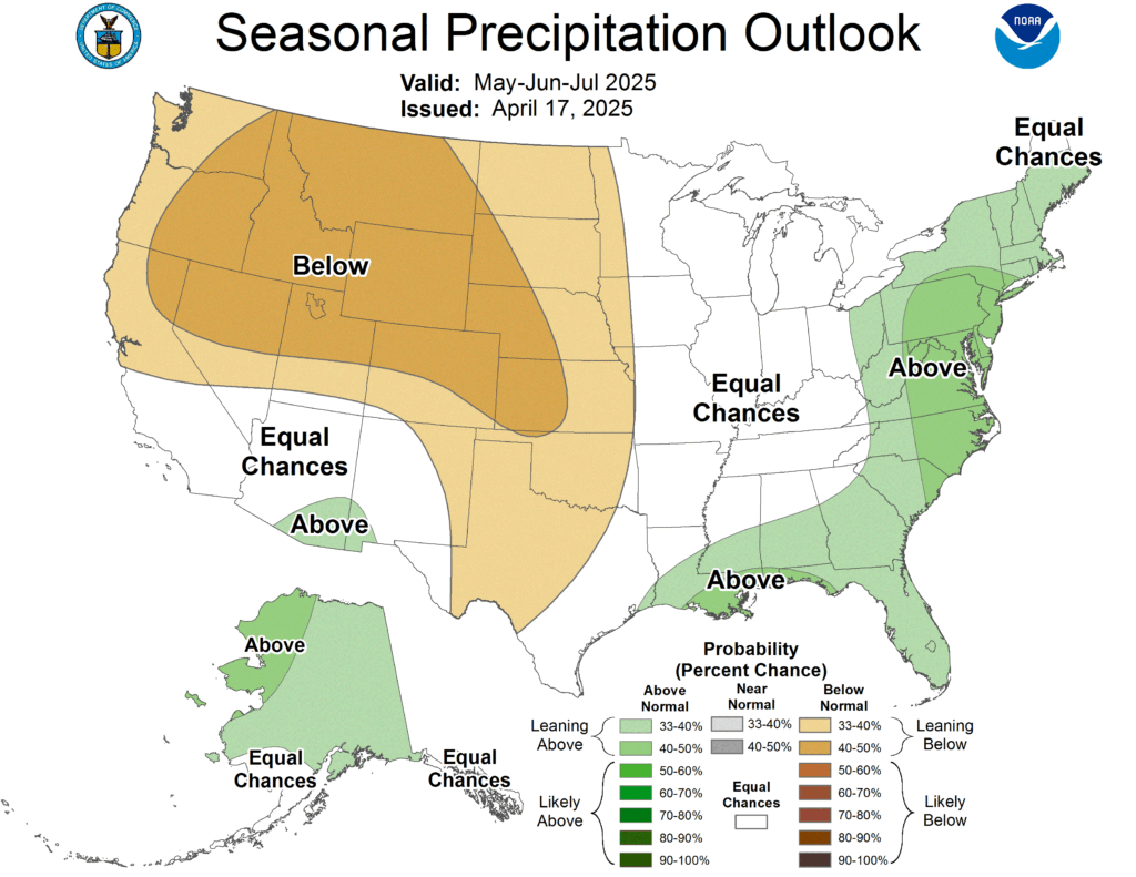
The Climate Prediction Center’s latest 6- to 10-day outlook shows wetter-than-normal conditions are likely in southeastern North Carolina through mid-May, and their seasonal outlook for May, June, and July also shows elevated odds of wetter weather across much of the state.
Water Supplies
Outlook: restrictions unlikely if rainfall matches demands
After holding steady through the La Niña-driven winter and start to spring, some reservoir levels began to feel the pressure during our warm and dry April. Last month, the Catawba-Wateree basin entered Stage 0 of its Low Inflow Protocol, which prompted reservoir operators along the river to operate more conservatively, such as reducing downstream releases to keep more water in storage.
If those May and early summer rains pan out, then that could offer a timely recharge for our lakes and groundwater supplies. But if we remain dry, then some local water systems could recommend conservation measures to ensure that supplies last through the summer.
Those measures are more likely in eastern areas where existing drought conditions are worse and where water supplies generally come from shallow groundwater stores, which saw limited recovery over the winter and have declined again this spring.
We can say that widespread restrictions are unlikely anytime soon. During the exceptional 2007 drought, it took a dry summer and our hottest August on record before a number of public water systems began to implement water use restrictions.
Wildfire Activity
Outlook: activity tapers off, but some local issues could remain
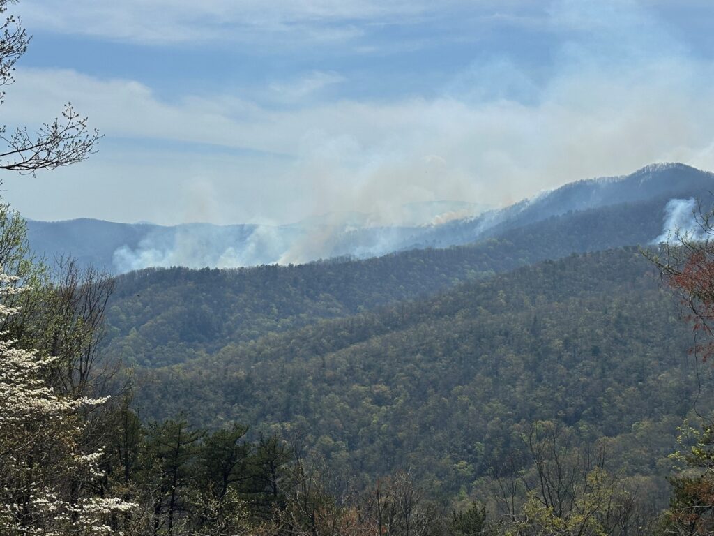
This spring fire season got off to a fast start in March and continued in April with several large incidents. Entering May, wildfire activity is becoming less widespread thanks to the progressing green-up, which recent satellite estimates show is more than halfway complete for most of the state. Green vegetation retains more moisture and its leaves help shade the understory, which keeps our forests from drying out as quickly.
But even as we enter the summer, fire danger could linger in some ecosystems. Downed trees in the Mountains from Hurricane Helene have fueled many of this spring’s fires, including April’s 2,085-acre Bee Rock Creek fire in McDowell County, and that debris will remain a ready fuel source this summer and for years to come.
At the coast, our highly organic soils are susceptible to lightning-caused fires, particularly during periods of severe drought like those regions are in now. The recent 950-acre Black Swamp fire in the Croatan National Forest has been burning in just such an environment, and its impacts have included poor air quality thanks to smoke infiltrating surrounding areas.
Agriculture
Outlook: planting slows until moisture levels improve
Farmers have avoided one obstacle so far this growing season with the lack of any late-season freezes, and a few decent doses of rain in March helped newly planted seeds get started in early April.
More recent dryness has slowed down planting in some areas such as Washington County, and statewide corn and tobacco planting has fallen slightly behind the five-year average per the latest USDA/NASS Crop Progress Report.
That’s a familiar experience for farmers, as just last year, a similarly dry April was shortly followed by an even drier June that fried the corn crop. While that summer flash drought came on with little warning, the current precipitation outlooks make such an event less likely this year.
That might just mean a short pause in the growing season until more rain arrives in May to boost our soil moisture levels and potentially alleviate our long-running drought.