
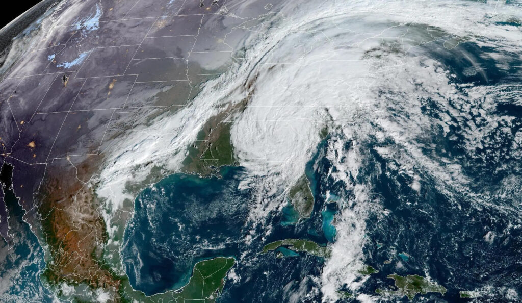
The tropics had one more surprise in store this season with Hurricane Nicole, which brought wet and windy weather as its remnants crossed North Carolina late last week.
Nicole was the 14th named storm of the year, matching the 30-year average for the basin. While 2022 was predicted to have above-normal activity, the nearly two-month lull in July and August ultimately limited this season’s potential even despite the late-season surge, which also included Hurricane Lisa and Hurricane Martin in the past three weeks.
Nicole initially formed as a subtropical storm – a hybrid system that includes some elements of a tropical storm, such as circulation around a center of low pressure, as well as non-tropical features such as a wide, open eye with clouds and rain extending far from the center.
It eventually moved over warmer water near the Bahamas and became a full-blown tropical system, even reaching Category-1 hurricane strength before hitting the Florida coast on Thursday.
However, it retained some of those subtropical characteristics as a large storm with tropical storm-force winds up to 450 miles from the center of circulation as it made landfall, according to the National Hurricane Center.
That meant its impacts were felt all across North Carolina as it moved through on Thursday night and Friday.
Rain and Wind in NC
Nicole brought at least half an inch of rain statewide, which was welcome relief for areas that have seen the emergence of drought in recent weeks.
The highest totals came along the Blue Ridge Escarpment, where moist air forced up the mountain slopes by southeasterly winds produced more than four inches of precipitation. Our Mount Mitchell ECONet station measured a two-day total of 7.73 inches, which was the most rain from a single storm there since an upper-level low pressure system in May 2020.
Nicole also snapped a two-month dry spell for many western areas that mostly missed out on the rain from Hurricane Ian in late September. Since September 11, the Asheville airport had received only 1.54 inches of rain and was more than 5 inches below normal. The 2.79 inches from Nicole effectively cut that deficit in half.
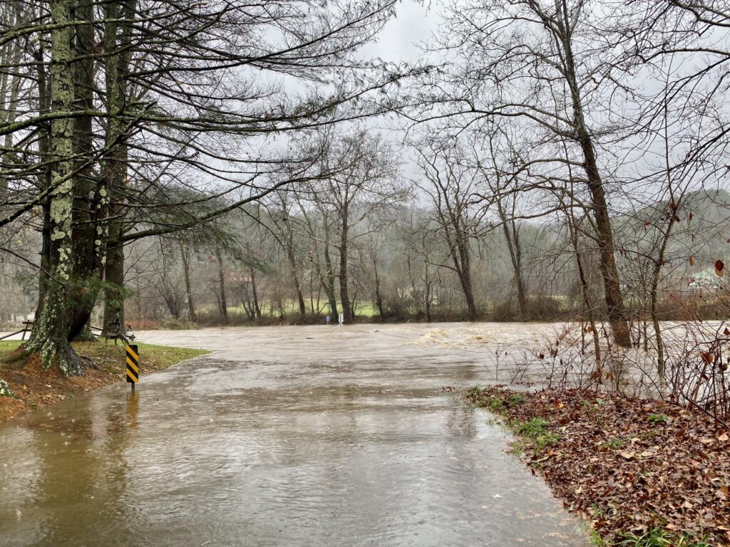
While several flash flood warnings were issued in the Mountains, river flooding was limited, largely because streamflows had dropped so much during the ongoing drought. Of note, the French Broad River at Blantyre briefly reached action stage as it crested late Friday and early Saturday.
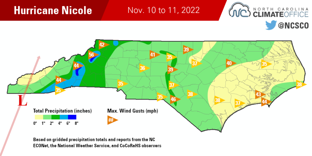
Not all drought-affected areas saw such high rainfall amounts, though. Graham and Swain counties, including the Great Smoky Mountains, had less than an inch of rain as the storm’s moisture mostly wrung itself out on slopes farther east. Bryson City received only 0.85 inches from Nicole and remains mired in its 2nd-driest fall since 2011.
Elsewhere, rainfall totaled 1 to 2 inches across the Piedmont and Sandhills, including 1.98 inches in Greensboro and 2.06 inches in Laurinburg. In eastern North Carolina, totals generally ranged from a half-inch to an inch and a half. The 0.92 inches in Wilmington was the first significant rain there since Ian more than a month ago.
Winds were not a widespread issue from Nicole; on Friday morning, less than 3,000 power outages were reported in North Carolina, compared to a peak of more than 360,000 during Ian. However, there were some gusty conditions especially in the west. A mile up atop Grandfather Mountain, winds gusted to 56 mph at 6:28 pm on Friday night.
Nicole’s final threat was a tornado risk associated with thunderstorms in its outer rain bands. The eastern half of the state was under a tornado watch on Friday morning, and funnel clouds were spotted near Siler City and Franklinton. As of this writing, the National Weather Service has not confirmed any tornadoes associated with Nicole in North Carolina.
Nicole Among Historical Storms
The track taken by Nicole, from its landfall along Florida’s east coast to its inland movement over western North Carolina, was similar to Jeanne in 2004. However, that storm’s impacts were much more pronounced than Nicole’s. Jeanne was the third tropical system in a month to soak the Mountains, and it ended that September with more flooding rains to cap off the wettest month ever recorded at some western locales.
Tropical systems affecting North Carolina this late in the year are a fairly uncommon event. A 2007 report by James Hudgins at the National Weather Service office in Blacksburg noted just 7 days in November with tropical cyclone activity in North Carolina in the previous two centuries. That’s compared with 119 such days in September – our climatologically most active month of hurricane season.
The last storm to affect us in November, and perhaps our most impactful November storm, was Tropical Storm Eta in 2020. While the center of Eta never reached North Carolina, moisture from the storm fed in ahead of a cold front and produced up to 9 inches of rain, which caused flooding issues in the western Piedmont and northern Coastal Plain.
While the rains from Nicole were less intense than Eta’s, they were also broadly beneficial given our recent dry spell. That made it a timely storm in an unusual time of year.