July featured the hottest weather of the year and a widespread lack of rainfall that helped Abnormally Dry conditions emerge for the first time in several months.

High Heat Hits Mid-Month
The summer heat sizzled last month, with the statewide average temperature of 78.10°F ranking as our 29th-warmest July out of the past 123 years. That average was 0.77°F above the long-term July average from 1981 to 2010. Compared to recent years, we were fractionally warmer than in July 2015 and about 1.4°F cooler than in July 2016.
While we didn’t have the persistent above-normal temperatures from last July, the mercury actually climbed higher last month than at any point last year. During a mid-month heat wave, an upper-level high pressure system over the Midwest funneled hot, dry air eastward and sent our temperatures soaring into the upper 90s and low 100s in a few spots.
On July 20, Dunn in Harnett County hit 101°F, tying last year’s highest observed temperature in the state. The Raleigh-Durham Airport also hit that mark on July 22, and the next day, it did one better, reaching 102°F — the first time it’s been that warm anywhere in the state since Lumberton hit 102°F on June 22, 2015.
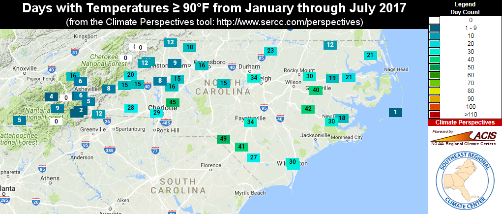
We also had plenty of days with highs in the 90s last month. Greensboro had yet to hit 90°F at the end of June, but they had 16 days at or above 90°F in July. Charlotte and Raleigh added 24 and 25 days at or above 90°F, respectively, to their year-to-date totals (below). However, both sites are still behind the 30-year average for number of days greater than or equal to 90°F through the end of July: 28.1 days in Charlotte, and 30.5 days in Raleigh.
Record Dryness in Parts of the Piedmont
Last month’s warm weather was accompanied by below-normal rainfall across much of the state. The statewide average precipitation of 4.80 inches ranks as the 40th-driest July since 1895, and is about a quarter-inch less than the 1981 to 2010 average for the month.
Conditions were driest across the northwest and central Piedmont. Two sites reported their driest July on record; in Yadkinville, the 0.95 inches of rainfall was the least observed going back to 1958, and Siler City‘s 0.56 inches was less than in any other July in the past 88 years.
Greensboro barely topped one inch of rain for the month, with 1.04 inches reported at the Piedmont Triad Airport. That’s the second-driest July since 1903; the only drier July at that site was in 1953.
Although much of the state saw less than 50% of their normal monthly rainfall, a few sites were on the wet side. Several rainfall events soaked the southern Foothills in the first half of the month, and with 10.86 inches observed, Tryon in Polk County reported its 6th-wettest July in the past 98 years.
The northeast Coastal Plain also received above-normal rainfall. Elizabeth City (8.74 inches) recorded its 5th-wettest July on record and Murfreesboro (9.89 inches) logged its 4th-wettest July since 1975.
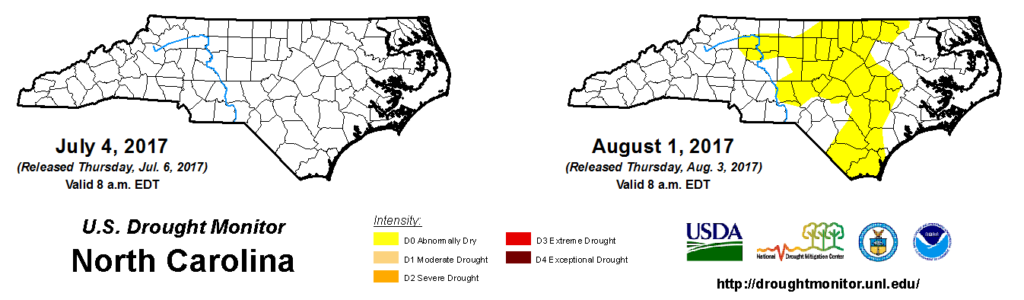
Abnormally Dry Conditions Return to NC
Stress on lawns, crops, and water systems is always high this time of the year due to increased evaporation and consumer demand, and that was certainly true last month as well.
As a result of these declining conditions, much of the Piedmont and parts of the central and southern Coastal Plain are now classified as Abnormally Dry by the US Drought Monitor, ending a two-month period with no dryness of note in the state.
The agriculture industry in particular has felt the effects of the recent hot, dry weather:
All crops are suffering from extreme heat. Tobacco continues to fire up and ripen quickly. Soybeans are wilting every day and pasture land is extremely dry. There are certain pockets as usual that have received rain recently, but overall the heat is causing some challenges for the crops.
Charles Mitchell, Franklin County Extension
You may be seeing some impacts in your backyard as well, such as those described in this CoCoRaHS Condition Monitoring Report:
The 15-acre pond is almost 4 inches below full. No water is flowing in. The 0.17 inches of rain did not offset the extreme heat of July 21-23. Native flowering dogwood and sassafras trees were observed in wilted condition. Native tulip poplars, planted well-established Catalpa trees, and other trees have leaves turning color and being shed.
From Johnston County, July 30
As the report above suggests, leaves browning and dropping early aren’t signs that fall is here. Rather, they’re indications that trees are fighting the stress of dry weather. Other plants may brown or wilt as well, especially since many of them developed shallow root systems during relatively dry conditions earlier this spring.
While we are seeing some short-term dryness, longer-term precipitation values are above-normal statewide. Because of that, the return of Abnormally Dry conditions doesn’t mean that drought is here or is likely to develop. Instead, it’s simply an acknowledgement of the toll that the July fry has had on the landscape.