As we crossed the midpoint of summer, hot and dry conditions again prevailed in July.

Above-Normal Temperatures Persist
For the fifth consecutive month, the statewide average temperature ranked above normal in what has been a warm spring and summer. Last month’s mean temperature of 77.73°F was 0.8°F above the long-term average, making it the 37th-warmest July out of 121 years of record.
The extreme hundred-degree heat from June backed off a bit in July; Raleigh’s highest temperature all month was just 94°F. However, the same basic weather pattern — mid-level ridging over the southern US — remained in place, which meant dry weather with temperatures slightly above normal.
The worst of the heat was concentrated in the southwestern Piedmont. Charlotte had just five days all month with below-normal temperatures, and 12 days with temperatures reaching 95°F or higher — tied for the fourth-most on record. Overall, Charlotte had its eighth-warmest July on record, and nearby sites in Concord, Hickory, and Laurinburg also finished with one of their top-ten warmest Julys.
Widespread Dryness Sees Drought Intensify
Rainfall was hard to come by last month, and the statewide average precipitation of 4.57 inches was 1.06 inches below the historical average, ranking as the 37th-driest July on record. The large-scale high pressure system over the Southeast US helped suppress showers and storms, limiting our precipitation.
Only a handful of sites reported above-normal precipitation for the month. The western mountain site in Murphy (8.79″ total, 3.7″ above normal), along with New Bern (7.85″ total, 1.7″ above normal) and Greenville (6.54″ total, 1.2″ above normal) received the most rainfall. Elsewhere, precipitation deficits of an inch or more were common. Wilmington and Lumberton each finished 4.2 inches below their normal July values.
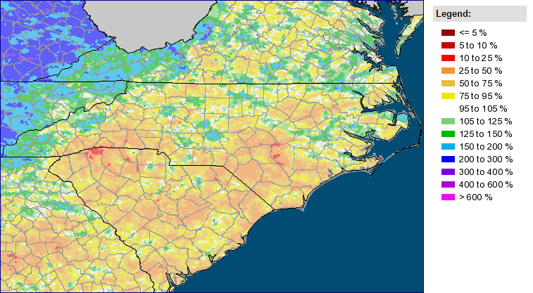
The lack of rainfall and sustained heat across the southwestern Piedmont meant drought conditions and their impacts worsened across that region. As we discussed in a blog post last week, the US Drought Monitor introduced D2, or Severe Drought, conditions in a three-county region, while D1 (Moderate Drought) conditions expanded slightly farther east into Stanly and Anson counties.
Another Muggy Month for Much of NC
There’s an old saying around these parts that “it’s not the heat but the humidity”. At least this summer, that seems to be the case for North Carolina. The average dew points for June and July, shown in the table below, show that this summer has been one of the muggiest on record for parts of the state.
| Site | Long-term average June/July dew point | Current June/July average dew point | 2015 ranking |
|---|---|---|---|
| Raleigh | 66.0°F | 68.4°F (+2.4°F) | 5th out of 72 years |
| Wilmington | 69.8°F | 71.5°F (+1.7°F) | 5th out of 68 years |
| Greensboro | 64.8°F | 66.1°F (+1.3°F) | 16th out of 67 years |
| Charlotte | 65.4°F | 65.1°F (-0.3°F) | 41st out of 76 years |
In Raleigh, it has been the muggiest summer since 1995, and Wilmington has also had its fifth-highest average dew point on record. Just outside of the current edge of drought conditions, Greensboro has had its 16th-highest average summer dew point.
In Charlotte, though, the effects of the drought are evident. The average dew point is 0.3°F below the long-term average, ranking 41st out of 76 years. Lower atmospheric moisture conditions are common in a drought. With less moisture in the soil, evaporation is reduced and the air remains drier. Notably, Charlotte’s average dew point for June and July of this year (65.4°F) is the same as for June and July of 2002, when Exceptional Drought (D4) conditions emerged across the Piedmont. That’s another sign of the impacts that the current dryness is having.