This post is part of our year-long series about North Carolina’s weather extremes.
The heat and humidity of a North Carolina summer can be uncomfortable enough in a typical year. But our state has a history of the heat ramping up, often for days at a time, and pushing our statewide high temperature record — and our discomfort — to even more extreme levels.
The Recipe for Record Heat
Although North Carolina is at a similar latitude to Death Valley, CA, we don’t see the same world record-setting heat as that desert locale. That’s largely because the nearby Gulf of Mexico and Atlantic Ocean, plus our ample surface water and vegetation, help add moisture to the air and moderate our temperatures. This tends to keep our maximum temperatures below 100°F, albeit with often oppressive humidity.
However, we can see temperatures climb well past the century mark when the right ingredients come together. Large-scale high pressure systems that develop over the southwest US become hot and dry, and they keep these characteristics as they slowly move eastward. Once these highs settle in across the southeast, the westerly circulation feeds in that warm, dry air.
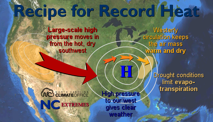
As the centers of these strong surface highs approach North Carolina from the west, the weather clears out, which allows for maximum heating. And during our record heat waves, drought conditions are often in place, which means less moisture in the soil and plants. This lets incoming solar radiation primarily heat the surface and surrounding air rather than supporting evapotranspiration.
In two of our historic heat waves in the past 80 years, these ingredients combined to produce record-setting temperatures.
July 1940 Heat Wave
Late July 1940 is remembered as one of the hottest sustained periods for much of the eastern US. Around the middle of the month, a ridge in the jet stream and an associated surface high-pressure system began moving eastward. Along the way, temperatures climbed as high as 116°F in Phillipsburg, Kansas, and 115°F in Pierre, South Dakota, tying that site’s all-time record high.
By July 21st, the surface high was firmly entrenched over the eastern US. As far north as Philadelphia, temperatures hit 100°F, and in Baltimore, the heat peaked at 103°F. Across North Carolina, where drought conditions had been building since the previous fall, temperatures climbed into the 90s and eventually the 100s.
The surface high continued to strengthen, and by the 28th, it was centered over the western Piedmont with sea level pressures of nearly 1020 millibars. Such high pressure and such close proximity to the center of the high helped the skies clear and the temperatures rise even more.
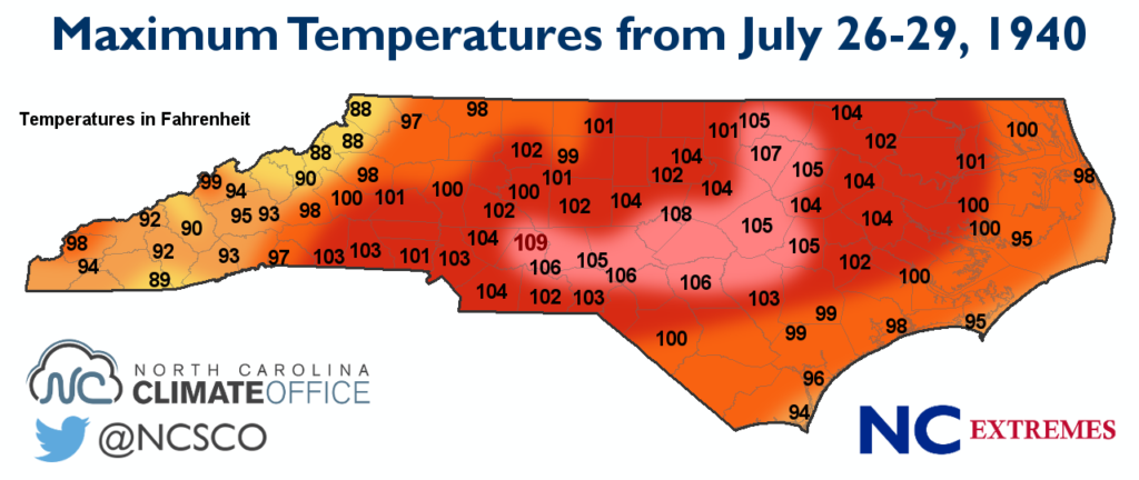
Outside of the mountains and immediate coast, the entire state saw temperatures hit 100°F or higher during the last week of July. The highest temperatures and most prolonged heat were centered over the southern and eastern Piedmont.
Albemarle in Stanly County hit 108°F on July 27th, tying the old statewide high temperature record. The next day, Albemarle reached 109°F to set a new record. That came during a nine-day streak — between July 21st and 29th — of temperatures hitting 100°F or higher.
Several other sites had eight-day streaks of hundred-degree heat. That list included Mount Gilead in Montgomery County, Southern Pines in Moore County, and Fayetteville in Cumberland County, which all peaked at 106°F.
In the years after the 1940 event, other heat waves enveloped the state and challenged the record. Most notably in 1954, a trio of events again saw statewide temperatures climb well into the triple digits. In mid-June 1954, Reidsville hit 108°F. In late June, Nashville reached 107°F. And on September 7th, Weldon in Halifax County tied the Albemarle record with a high of 109°F.
During the 1960s and 70s, extreme heat was far less common in North Carolina. Between 1959 and 1976, Raleigh went 17 straight years without hitting 100°F, and Charlotte and Greensboro each hit 100°F just once during this time. But in the early 80s, another challenger to the record emerged.
August 1983 Heat Wave
The summer of 1983 was tailor-made for extreme heat. A drier-than-normal May and June preceded the driest July on record statewide, and flash drought conditions emerged. The only ingredient missing to crank up the heat was a hot, dry air mass from the west.
Right on cue, in mid-August, a large-scale ridge in the jet stream set up across the midwest, bringing hundred-degree heat to the central Plains. A surface high moved eastward, just ahead of the landfalling Hurricane Alicia, and settled in over the southeast.
Ahead of that high, a stationary front moved through North Carolina on August 20th, pushing statewide temperatures from the mid-90s into the low-100s. And like in the 1940 event, when the center of the high moved over western North Carolina, the mercury climbed even higher on August 21st.
From the western Piedmont to the central Coastal Plain, most stations reached temperatures of 103°F or higher. Even Asheville hit 100°F: an event that’s only happened three times since 1946. The southern Piedmont again saw the worst of the heat, with several sites including Albemarle getting to 107°F.
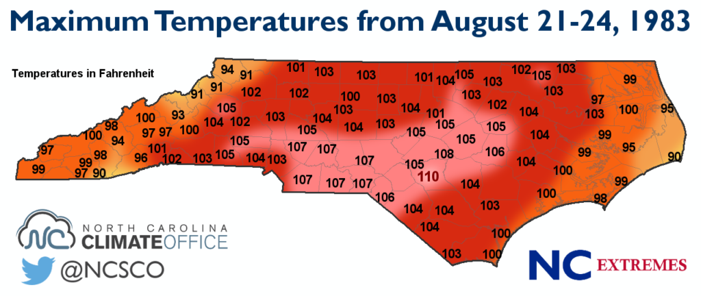
At the Fayetteville Airport, morning cloud cover cleared out and temperatures quickly began to rise from the low of 76°F. By noon, the temperature was up to 102°F. As winds then switched from northeasterly to easterly, the dew point dropped from 71°F to 68°F, and the temperature continued to climb. At 1 pm, it was 105°F. At 2 pm, 106°F. And at 3 pm under clear skies, the reported temperature was 109°F.
However, that was only the highest reported temperature at the top of any hour. At the midnight GMT observation, the station’s observer noted the daily maximum temperature of 110°F. That gave Fayetteville sole ownership of North Carolina’s high temperature record.
The August 1983 heat wave lasted for several more days before the same stationary front that brought in the heat sagged back southward, dropping highs into the low 80s by the 25th. However, the summer of 1983 remains one of the worst on record for heat-related fatalities, with 17 reported in North Carolina.
Since then, we’ve seen several more heat waves, including recent ones in 2011 and 2012, but a new challenger to the record has yet to emerge. The highest temperature we’ve seen across the state since 1983 is 108°F at two Richmond County sites on August 9, 2007.
With the right ingredients in place, we know record-breaking heat is possible. So the question may not be if, but when this record is broken. And whether you’ll dare to venture outside, braving the heat and humidity to witness it.