In the first part of our 2014 climate review for North Carolina, we look at some statewide statistics and extremes from the past year.
Temperatures
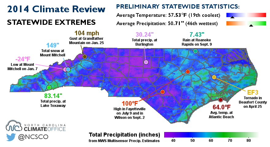
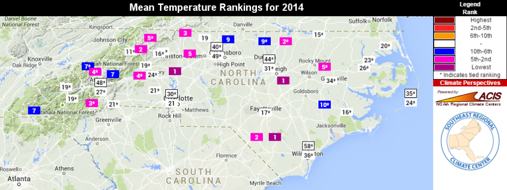
- The statewide average temperature was 57.53°F, making 2014 the 19th-coldest year in the past 120 years, and the coolest since 1988.
- The warmest location was Atlantic Beach in Carteret County, which had an annual average temperature of 64.0°F. The normal average at that location is 62.6°F.
- The coldest location, on average, was Mount Mitchell, which had an annual average temperature of 43.0°F. That was near the normal value of 42.6°F.
- The highest reported temperature in 2014 was 100°F. It happened twice: in Fayetteville on July 9th, and in Wilson on September 2nd. Outside of those spots, the rest of the state hasn’t seen temperatures at or above 100 degrees since July 2012.
- The lowest reported temperature was -24°F at Mount Mitchell during the statewide cold air outbreak on January 7th. That morning, our ECONet site on Mount Mitchell dropped to -18.8°F, but the mercury dipped even lower at the National Weather Service’s Cooperative Observer station, reaching 24 degrees below zero. It wasn’t a new all-time record, though. That honor also belongs to the Mount Mitchell station, which hit -34°F on January 21, 1985.
Precipitation
- The statewide average precipitation was 50.71 inches for 2014, ranking as the 46th-wettest year in the past 120 years.
- Lake Toxaway received 83.14 inches of precipitation, upholding its title as the wettest spot in North Carolina. This year’s total was about 8 percent below the normal value of 90.51 inches.
- On the drier end of the spectrum, the Burlington Airport received just 30.24 inches of precipitation for the year — nearly 15 inches below normal. Burlington and other parts of the northwest Piedmont were classified in Abnormally Dry conditions for much of the summer and fall.
- Despite that dryness, 0 percent of North Carolina was classified in drought conditions during 2014 by the US Drought Monitor. In fact, the state hasn’t seen drought conditions since April 2013.
- The greatest daily precipitation total was 7.43 inches, which occurred on September 9th in Roanoke Rapids. A low pressure system moving up the coast brought heavy showers and a day-long rain event to sites near Lake Gaston. Rainfall reports from volunteer CoCoRaHS observers nearby helped confirm the high local accumulations.
- 149 inches of snow fell at Mount Mitchell, which was the most since 2010 (187 inches). The runner-up was Beech Mountain, which received 96.7 inches of snow last year.
Weather Events
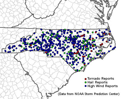
- 30 confirmed tornadoes occurred, including ten EF1, five EF2, and one EF3. Nine of these, including the EF3 tornado in Beaufort County, occurred during the April 25 severe weather event along the coast. These 30 tornadoes resulted in 25 injuries but no fatalities.
- A 104 mph wind gust at Grandfather Mountain was the highest reported in 2014. It happened on January 25th at 9 pm, with temperatures in the teens and sustained winds of 60+ mph. A close second place was a 101 mph gust at Cape Lookout on July 3rd as the eye of Hurricane Arthur approached.
- Speaking of Arthur, it set a record as the earliest known landfalling hurricane in North Carolina when it came ashore late on July 3rd at category-two strength. Arthur was the only tropical storm to hit the U.S. during the relatively inactive 2014 season.