Rapid Reaction: Debby Drenches NC in Multi-Day Rain Event
An expected active hurricane season took its first swipe at North Carolina last week, with four days of rainfall from the slow-moving Tropical Storm Debby soaking much of the state.
That heavy rain fell on already saturated soils and streams following a record wet July for parts of eastern North Carolina, which created flooding issues as our major rivers reached major flood stage.
And Debby’s damage went beyond just flooding. Tornadoes embedded in its outer bands also left a mark on towns across eastern North Carolina, adding to the impacts from a tropical storm that punched above its weight.
A Slow-Speed Arrival
Debby’s path to North Carolina began on the last day of July, when a tropical disturbance moved over the warm water in the northern Caribbean Sea. After riding over the rugged terrain of Puerto Rico, Hispaniola, and Cuba, Debby became a tropical storm on Saturday, August 3.
In its short trip northward toward the Gulf coast, Debby reached Category-1 hurricane strength. However, in a bit of foreshadowing for our state, the worst damage in Florida wasn’t from the winds near the eye, but from flooding along Florida’s coast, including in Sarasota after more than 17 inches of rain fell locally.
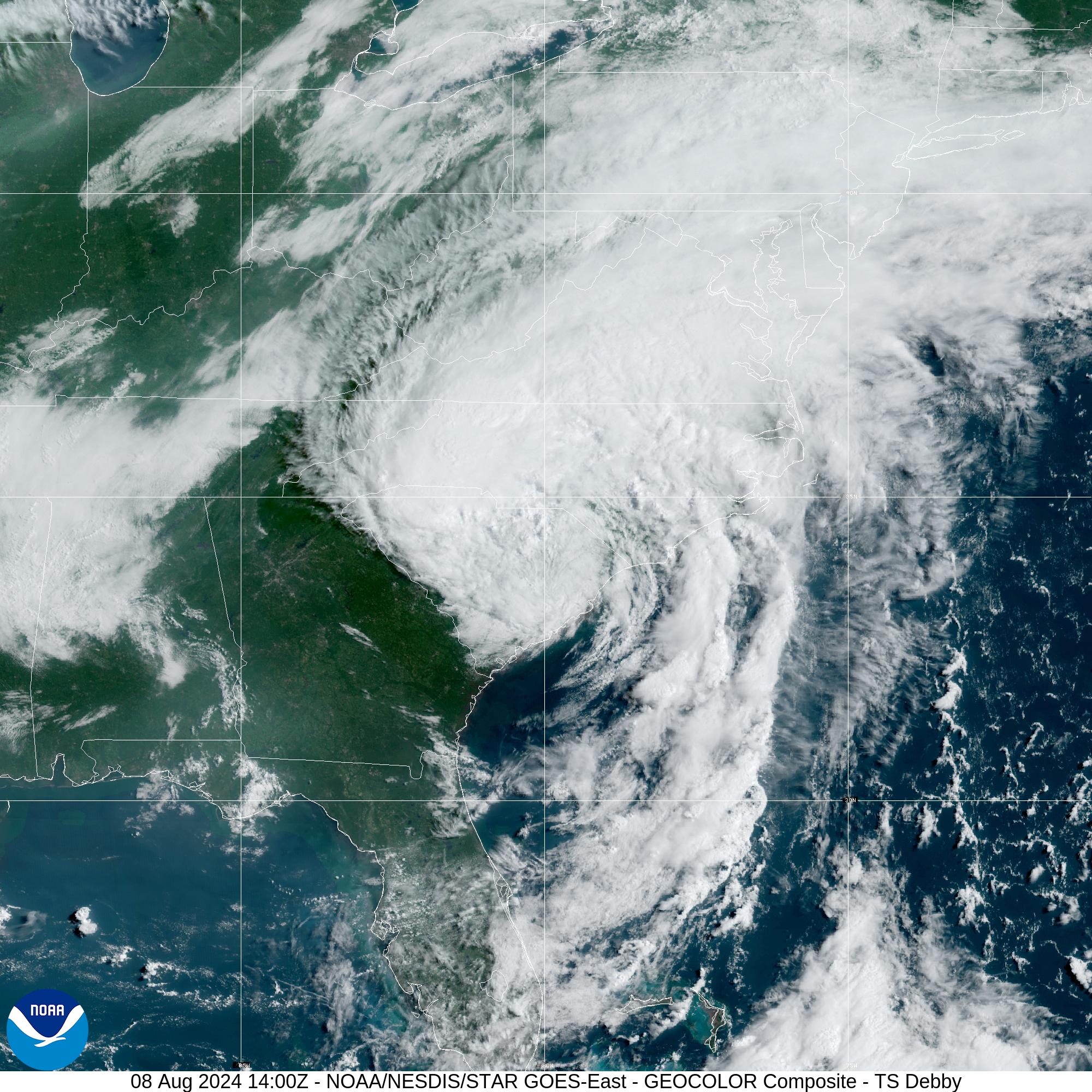
The storm then crossed over to the Atlantic coast, continuing a northward track en route to a landfall in South Carolina, similar to Hurricane Ian in 2022.
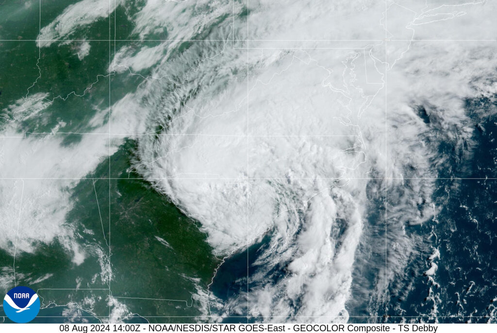
But Debby also slowed significantly, as it was effectively boxed in by high pressure to the east and west and a stalled front to the north. When it reemerged off the coast of Georgia last Tuesday, Debby had a forward speed of just 3 miles per hour – a throwback to the plodding pace Florence took across the Carolinas six years ago.
As the outer bands sprawled out ahead of the storm, rain overspread North Carolina beginning on Tuesday morning. Over the first 24 hours, the southern coastline saw the heaviest rain, including 5.66 inches in Wilmington – its highest daily total since Hurricane Dorian in 2019.
By early Thursday morning as the storm neared its landfall just north of Charleston, SC, its rain began spreading westward across the Piedmont. Totals in that region on Thursday neared or exceeded four inches, including 3.91 inches in Greensboro, 4.02 inches in Raleigh, and 4.24 inches in Charlotte.
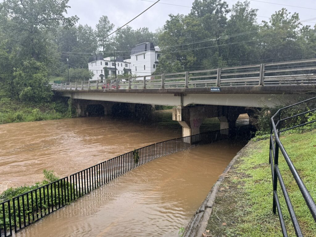
The center of downgraded Tropical Depression Debby exited to our north early Friday morning, but rain lingered throughout the day across the eastern half of the state. Farther west, more showers associated with a passing cold front dropped an additional 2 to 5 inches of rain across parts of the Piedmont, leading to flooding and multiple water rescues in Guilford County.
Heavy Rain and Other Hazards
During four wet days, Debby dropped more than six inches of rain over southeastern North Carolina, with several areas seeing more than ten inches such as the 10.70 inches in Wilmington. Among our ECONet, 13 of the 45 stations recorded at least 5 inches of rain, including 9.12 inches in Castle Hayne and 8.91 inches in Whiteville.
That rain added to what we received in July to continue a recent soaking wet weather pattern, especially across eastern North Carolina. With 4.46 inches of rain from Debby as of August 9, Greenville had 19.40 inches in the previous 30 days – more than one third of its annual average precipitation falling in just one month.
The highest amounts from Debby occurred in northern Brunswick County. A citizen weather observer in Leland had a storm total of 15.75 inches, while a pair of nearby CoCoRaHS observers each recorded more than 14 inches. Elsewhere in the county, Shallotte had 10.34 inches, which was its 4th-highest total over a unique four-day period since that station began observing in 2000.
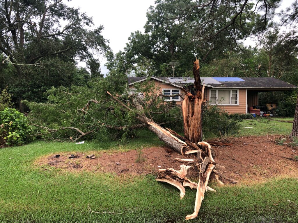
Tree roots were weakened in the rain-soaked ground, and together with gusty winds – with peak gusts of 52 mph in both Fayetteville and Greensboro – that created a recipe for falling trees and power outages. The governor’s office notes a total of almost 480,000 outages across the state.
While Debby was a low-end tropical storm with maximum sustained winds of just 50 mph when it made landfall along the South Carolina coast on Thursday morning, it packed a surprisingly severe punch within its outer bands.
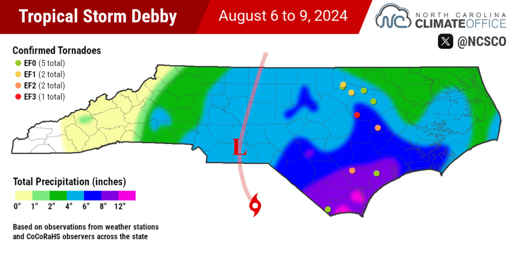
The National Weather Service has confirmed 10 tornadoes in North Carolina during Debby, which is the most in the state from a tropical system since the 11 from Hurricane Isaias in 2020.
Three tornadoes touched down in Franklin County, along with a pair in Pender County (with one later moving into Sampson County) and one each in Brunswick, Edgecombe, Greene, Nash, and Wilson counties. The Wilson County tornado, which damaged Springfield Middle School in the town of Lucama, reached EF3 strength with winds of 140 mph.
That’s an unusually strong tornado for a tropical storm. In fact, it was only the third F3 or EF3 tornado on record in North Carolina associated with a tropical system. Isaias spawned an EF3 tornado in Bertie County, and Hurricane Cleo in 1964 spawned an F3 tornado in Scotland County.
Three fatalities in North Carolina are blamed on Debby. The Lucama tornado caused a home to collapse, killing the man inside. In Rockingham County, a woman was killed when a tree fell on her home. And in Robeson County, a woman died after her car was swept away by floodwater.
Rising Rivers and Familiar Flooding
Debby’s timing immediately following our wet July meant there was little room in soils or streams to store excess moisture, so that water ran off into rivers and has caused some high crests since the storm moved out.
Gauges on three of our major rivers reached major flood stage over the weekend. The Lumber River in Lumberton crested almost two feet above its major flood stage, while the Tar River at Louisburg surpassed its major flood stage for the first time since Hurricane Matthew in 2016.
In Cumberland County, which saw local totals of more than eight inches, the Little River at Manchester hit its sixth-highest crest on record at 27.71 feet, behind only peaks associated with Florence, Matthew, and the September 1945 hurricane.
Elsewhere in the county, parts of Interstate 95 were closed due to flooding on the roadway, and a dam was breached in Fayetteville by rushing water. Another breach was reported in Harnett County when an earthen dam surrounding a pond failed, which prompted local evacuations.
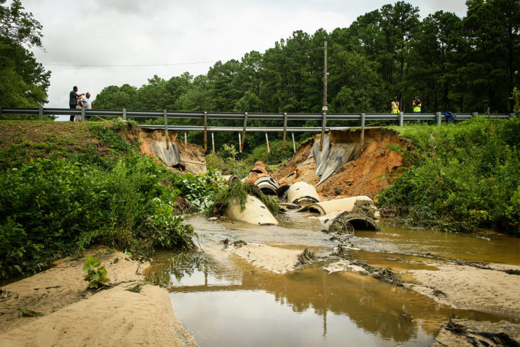
On Monday, another river gauge hit major flood stage. The Northeast Cape Fear River near Burgaw was at 16.13 feet and still rising, with a peak expected on Tuesday morning — a full seven days after the rain from Debby first started falling. Other sites across far eastern North Carolina may also crest early this week as water continues working its way downstream.
While Debby’s flooding fortunately wasn’t as widespread as we saw after Matthew or Florence, many of the same areas are being affected, which makes this their third major flood event within the past eight years.
That increased frequency and magnitude of extreme rainfall events from tropical systems is consistent with what we expect in a warming climate. Slow-moving storms like Debby are also becoming more common as global tropical circulations weaken due to climate change. One study noted a 16% slowdown for storms affecting land areas in the North Atlantic between 1949 and 2016. Combined with a warmer, wetter atmosphere, that has boosted rainfall totals by about 25%.
This was also our latest reminder that maximum wind speeds or minimum pressure rarely tell the full story of a storm, particularly during a long-lived event defined more by impacts far from the center such as heavy rain and deadly tornadoes.
Debby’s ultimate legacy may be shaped by how the rest of this hurricane season turns out, and whether it’s one of a kind or the first of several storms to affect us this year.
For now, we see it as a tropical storm with the attitude (and impacts) of a hurricane, and a reminder of other recent storms that left a mark, from a northward track by way of South Carolina like Ian to the crawling pace of Florence to the flooded roads and dam breaches in Fayetteville reminiscent of Matthew.
- Categories:


