July’s Soaking Showers Stop Drought in its Tracks

Last month started with more extreme heat, but a wetter pattern followed that brought improvements to our summer drought.
Heat Continues in Early July
Hot weather especially early in the month made for an overall warmer-than-normal July in North Carolina. The National Centers for Environmental Information (NCEI) reports a preliminary statewide average temperature of 79.3°F, which made it our 9th-warmest July out of the past 130 years.
Locally, it was tied for the 5th-warmest July on record in Charlotte and Hickory – and the warmest for both sites since 2016 – and the 4th-warmest in Lumberton dating back 111 years.
July started where June left off, with extreme heat in the first two weeks of the month. Under an upper-level high pressure system over the Southeast US, our temperatures climbed well into the 90s over the Independence Day weekend.
On July 5, several sites avoided afternoon rain showers to record their hottest days of the summer so far. In the west, Charlotte hit 101°F: its first triple-digit reading in more than two years. Farther east, the mercury climbed to 103°F in Lumberton, 104°F in Hamlet, and 106°F in Raleigh, which was the hottest temperature ever recorded at the Raleigh-Durham Airport.
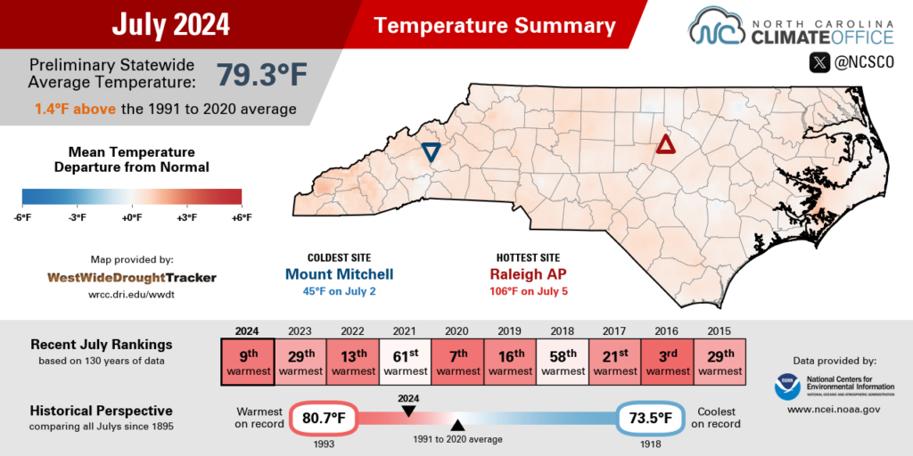
While that reading was confirmed by an on-site technician that day, local factors such as the gravel ground cover beneath the weather station and winds blowing down the length of the runway are known to affect RDU’s temperatures on these hottest days. We know it’s not alone, though. Our Urban Heat Mapping Campaign in 2021 found the airport was one of several hot spots in the Triangle where land use gives a boost to ambient temperatures.
A timely cold frontal passage later that weekend helped temper our temperatures, although the heat returned the following week, even in typically cooler western areas. From July 14 to 16, North Wilkesboro had three consecutive days with high temperatures at or above 95°F; its longest such streak since July 2012.
After that, we transitioned to a more seasonable pattern, with regular frontal passages and unsettled weather keeping our highs in the 80s to low 90s most days. On July 25 amid off-and-on rain showers, the Raleigh Airport site topped out at just 79°F, ending a 54-day streak with highs hitting at least 80°F that began on June 1.
On a cloudy day, that offered a light at the end of the tunnel that our sweltering summer’s days are numbered. Of course, August may have something to say about that first.
A Precipitation Pattern Reversal
Rain returned in extreme amounts last month, fueling one of our wettest Julys on record. Preliminary data from NCEI shows a statewide average precipitation of 8.29 inches last month, ranking as our 11th-wettest July since 1895.
That represents a remarkable rainfall turnaround in just one month, following what officially finished as our 2nd-driest June on record. That rapid switch from dry to wet is also reflected in local rankings: from the 4th-driest June to the 5th-wettest July in Lincolnton; from the driest June in New Bern to the 3rd-wettest July; and from Greenville’s 2nd-driest June – with just 0.45 inches of rain all month – to the record wettest July out of 94 years of observations, with 14.30 inches.
Indeed, after finishing June with less than 2 inches of total precipitation, much of northeastern North Carolina recorded more than 10 inches in July. Washington had 17.84 inches, Cape Carteret had 14.88 inches, and our ECONet station in Rocky Mount had 12.86 inches, among other high totals.
While daily showers and thunderstorms were common throughout the month, the heaviest rains came from a pair of stalled frontal boundaries on two consecutive weekends: first beginning on July 11, and again on July 18. Southwesterly winds carried in moist air along these fronts, which fueled slow-moving showers and extreme rainfall totals.
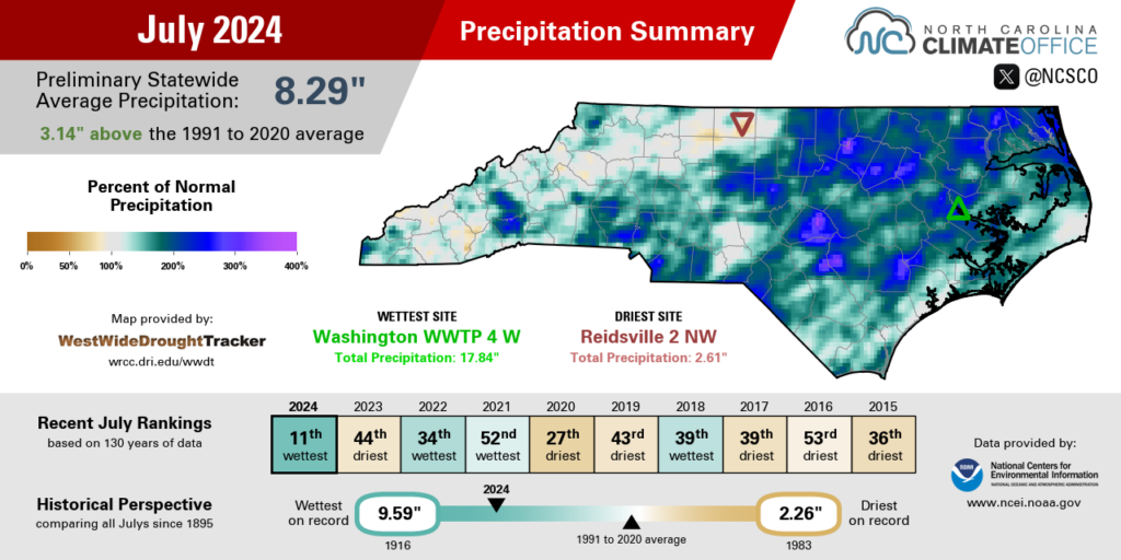
The 5.03 inches in Greenville on July 11 was the most ever recorded on any July day there. On July 18, Elizabeth City had 4.08 inches – its wettest day since Hurricane Dorian in 2019. And in the Piedmont, Graham had 3.45 inches on July 25 , which was its highest daily total since September 2018 during Hurricane Florence.
It wasn’t just the rainfall amounts that were impressive last month. It was also their regularity. During a time of year when rain can be hit or miss, showers and storms were a reliable daily occurrence in parts of the state last month.
Following a streak of 19 consecutive days with no measurable rainfall in June, Fayetteville had 10 days in a row with rainfall recorded in July: the longest such streak since the fall of 2015. Lillington and Williamston also had 10 consecutive days with rain during their wettest and 3rd-wettest Julys on record, respectively.
It was also a wet month for the northern and central Mountains, including the 4th-wettest out of 92 years in Jefferson and the 5th-wettest July on record in Asheville with more than double its normal monthly rainfall.
The western Piedmont had lower totals last month compared to the rest of the state, but some areas were still slightly above their normal rainfall. Charlotte and Hickory were each about 1.5 inches above normal, and Greensboro was more than 5 inches above normal in its 7th-wettest July on record.
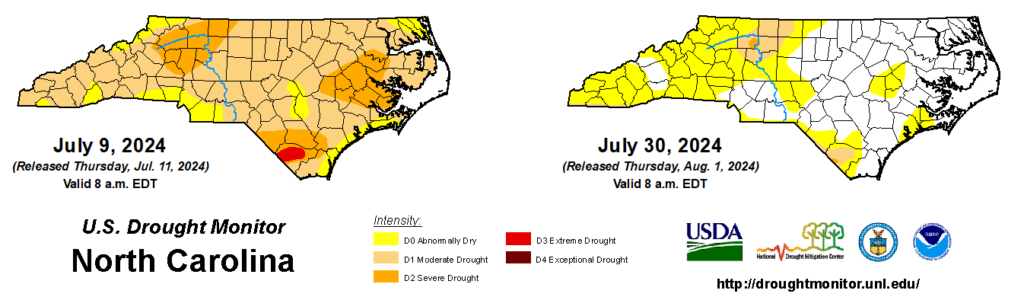
Drought Driven Back by July Rain
In early July, the US Drought Monitor map was in dire shape across North Carolina. By July 9, drought covered 88% of the state, and Extreme Drought – the second most severe drought category – had returned to eastern North Carolina for the first time since August 2011.
But as quickly as that drought developed in June, it seemed to vanish in July. The back-to-back weekends with steady, soaking rain events helped soil moisture conditions recover, while lakes and streams also saw big boosts in a short time.
The month-to-month turnaround was also evident in those water levels: streamflows in southern Orange and Durham counties were at provisional record low levels for June, but those same sites were running above normal by the end of July.
Our July rainfall more than made up for our June deficits in most areas, leaving our summer-to-date precipitation near or slightly above normal. Fayetteville is running even with its average rainfall for the past two months, just 0.09 inches above normal. And through the end of July, Raleigh is 2.92 inches above normal while Asheville is 2.73 inches above normal.
Some dryness and drought remains in areas that are still at a slight deficit for the summer season. That includes parts of the northwest Piedmont such as Yadkinville, which is 3.15 inches below normal, and Reidsville, which is 4.80 inches below normal since June 1.
The other lingering sign of our June drought can be found on the corn stalks – or at least what’s left of them. For early planted corn, hopes for high yields this year were popped by the hot, dry weather in June, which set in just as the corn was going through the most moisture-sensitive part of its development process.
While that corn may be tough to salvage in this growing season, late July brought more promising signs for other crops, with soybeans, tobacco, and pastures all springing back to life thanks to the rainfall.
With such a quick recovery and few lasting impacts of this summer’s drought, it’s likely to be just a blip on the timeline of 2024 when we look back on this year. That will obscure just how severe this drought was and how quickly it got to that point, but it’s also a testament to how significant and beneficial our July rains were across the state.
- Categories:


