Unwrapping Our Weather Tricks and Treats from October

Due to the ongoing federal government shutdown, the usual temperature and precipitation statistics and rankings from our partners at the National Centers for Environmental Information remain unavailable. In lieu of that, we’ve included some different maps and more local rankings in this month’s climate summary.
Entering last month, our two biggest weather stories were the prevailing fall-like temperatures since early August and the developing drought in parts of North Carolina. October saw a continuation of those stories, which represented both a treat and a trick from Mother Nature.
But there was more than just those weather features filling our baskets last month. As we review October’s weather, we’ll highlight both the pleasant patterns and spooky surprises with our temperatures, precipitation, and forestry impacts.
Tumbling Temperatures All Month
That first treat of note was yet another month adorned by seasonable temperatures, on average. Following a slightly cooler-than-normal September, October brought more of the same, with mean temperatures mostly near normal.
Among the coolest sites, Laurinburg was 4 degrees below normal, tied for its 14th-driest October since 1946, and Wilmington was 2 degrees below normal and tied for its 41st-coolest October in the past 150 years.
Major airport sites in Asheville, Fayetteville, Greensboro, and Raleigh each finished about 1 degree cooler than normal, near the middle of their historical October rankings. Charlotte was a degree warmer than normal, tied for its 58th-warmest October on record.

Despite those middling rankings, our temperatures weren’t perfectly fall-like all month. We started with a trick, at least at this time of year: a summer-like spell early in the month. On October 7, our high temperatures topped out in the mid-80s across the eastern half of the state, including 86°F in Raleigh and Greenville, and 84°F in Roxboro – the hottest weather on that day at all four sites since 2018.
After a mid-month cold frontal passage, the seasonable weather finally settled in, giving ideal conditions for the State Fair from October 16 to 26. The daily average temperature of 57.9°F made this the coolest State Fair since 2015, and the warmest day on October 18 only hit 81°F.
Fittingly for Halloween week, we had a dreary end to October during a multi-day rain event. From October 26 to 30, our temperatures were largely locked in the 40s and 50s, and Raleigh recorded 95 consecutive hours with mostly cloudy or overcast skies — its longest such streak so far this year.

Drought Drags On, But Rain Returns
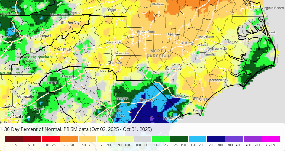
Once the final monthly numbers were totaled through Halloween, we ended up with a mixed bag of precipitation across North Carolina in October.
Parts of the southern Mountains and southern Coastal Plain had more plentiful precipitation than normal, including Murphy in its 16th-wettest October in the past 50 years, Marion in its 37th-wettest October, and Lumberton with its 31st-wettest October on record.
But many areas missed out on rainfall rewards, leaving them drier than normal. Some northern sites finished with less than two inches of total precipitation, including Greensboro with 1.67 inches in its 42nd-driest October in the past 123 years, Reidsville with 1.77 inches in its 16th-driest October since 1962, and Roanoke Rapids with 1.84 inches and its 14th-driest October on record.
With more dry areas than wet ones statewide, October saw a further degradation of our drought, including the expansion of Moderate Drought (D1) into the Piedmont and the addition of Severe Drought (D2) in parts of the northern and central Coastal Plain. That made this our fifth consecutive fall with Severe Drought present in parts of North Carolina.
But October also had two rounds of significant rainfall that helped slow down drought’s development. On October 12 and 13, an offshore Nor’easter brought more than 2 inches of rain along our southern coastline, and in the final days of the month, a low-pressure system to our south produced widespread three-day totals of 2 inches or more.
Prior to the mid-month rain, Snow Hill had gone 41 consecutive days with less than a quarter-inch of rainfall: its longest such streak since the end of 2020. Nearby Kinston rebounded from its driest September on record with 3.22 inches in October – only 0.34 inches shy of the monthly normal rainfall.
One positive impact of that rainfall was stabilizing streamflow levels, especially in eastern North Carolina. On October 24, discharge levels on the Neuse River at Kinston dropped to just 430 cubic feet per second – the lowest flows there since last July. But after the late-month rainfall, average streamflows in the final week of the month rebounded into the normal range across the Neuse and many other river basins.
In other spots, October’s rains were too much of a good thing – a classic be-careful-what-you-wish-for sort of trick. Columbus County had localized flooding during the Nor’easter event, with one weather station in Whiteville recording 6.32 inches of rain in just nine hours on October 12 – the wettest day at that site since Hurricane Florence in September 2018.
And aided by those storm systems, coastal erosion continued along the Outer Banks, with 11 homes in Buxton and one in Rodanthe collapsing into the ocean between September 30 and October 28. That continued a tumultuous few months along our coastline dating back to Hurricane Erin in August.

Tricks and Treats Among the Trees
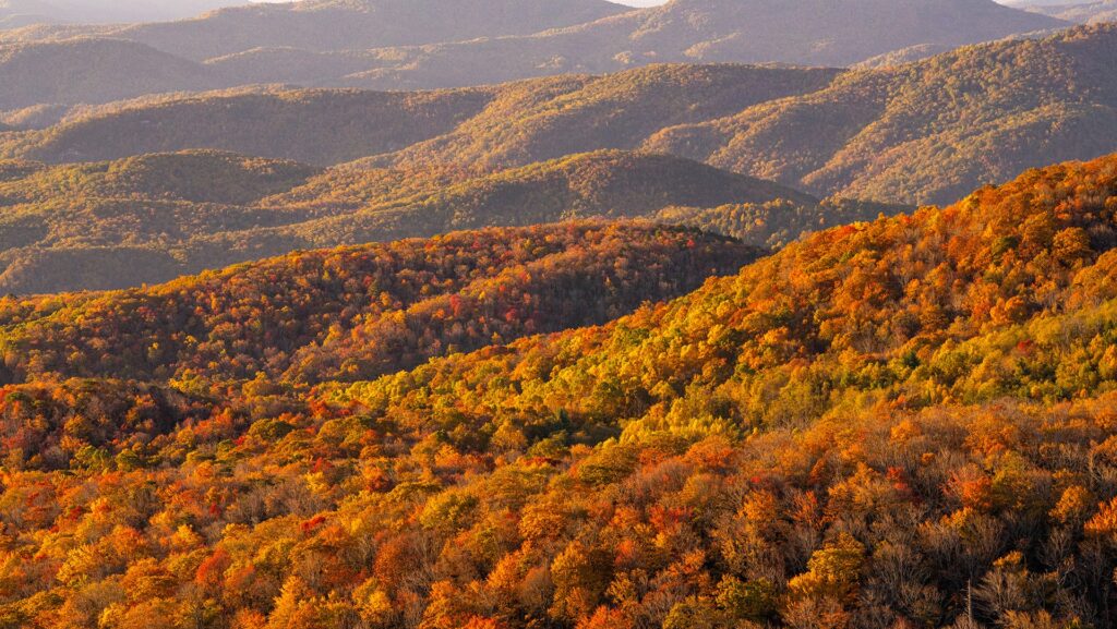
October both revealed the present beauty and hinted at the upcoming beast in our forests, which is all part of the environmental progression at this time of year.
A beautiful treat came from a vibrant peak of fall color in the Mountains, which occurred roughly at its usual timing in mid-to-late October. That color change was aided by sunny days and cool nights, including eight nights last month with temperatures below freezing on Grandfather Mountain – the most there in October since 2014.
The weather also played a more destructive role for the fall leaves, with breezy conditions causing a big leaf blowdown late in the month. On October 28, wind gusts reached up to 37 mph in Raleigh, 39 mph in Laurinburg, and 50 mph in Duck.
With some trees dropping their leaves early due to drought and others being stripped of their leaves by the winds, November could offer a less impressive show of fall color in parts of the Piedmont and Coastal Plain.
Falling leaves often kickstart the fall fire season, but our late-month rainfall did helpfully tamp down the fire risk, at least in the short term. After fire danger peaked in the Very High range in parts of the Mountains on October 25, the following rain event saturated duff and fine fuels, including fallen leaves.
However, we’re not out of the woods for an active fall fire season just yet, based on a naughty November outlook.The Climate Prediction Center shows a slight tilt toward below-normal precipitation this month, and the National Interagency Fire Center expects an above-normal risk of significant wildland fires including in the Mountains, where the risk is further enhanced by lingering damage from Helene in their forests.
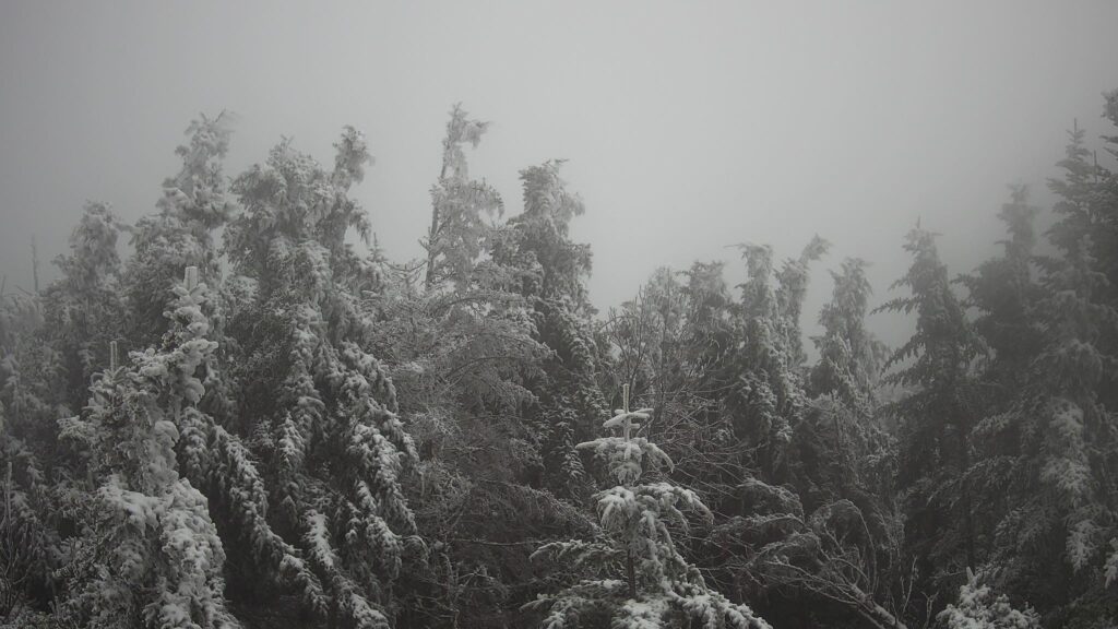
One final sign of the season in our mile-high forests was the first snow of the fall at Mount Mitchell on October 30. Since 1980, the average date for the first measurable snowfall there is November 12, so this year’s first flakes happened about two weeks earlier than normal.
If you believe the folklore, another sign of snow crawled in at last month’s Woolly Worm Festival in Banner Elk. Based on its black and brown bands, the winning worm named Billy was said to portend mostly snowy, frosty, and chilly weather this winter. Depending on your perspective about winter precipitation, that could be either a trick or a treat!
We’ve previously noted that woolly worms’ colorful bands develop as they grow each spring and summer, so they may be a better representation of our past weather – and last winter was certainly a snowy one.
If you want a second opinion about our upcoming winter’s weather, stay tuned to the Climate Blog for the release of our annual winter outlook on November 19.
- Categories:


