
Springtime showers and storms made for a wet May, while summer-like temperatures settled in during the month. That wrapped up an overall warm, wet, and stormy spring.
Rainfall Races Back In
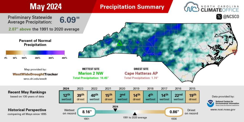
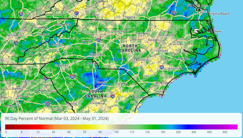
On the heels of a dry April, regular rainfall returned across North Carolina in May. The National Centers for Environmental Information (NCEI) notes a preliminary statewide average precipitation of 6.09 inches and our 12th-wettest May since 1895.
While almost all of the state saw above-normal rainfall last month, the heaviest and most frequent showers seemed to zero in on the western Piedmont, which had more than 7 inches in total.
On the first Sunday of the month, showers along a stationary front dropped up to 2 inches of rain in Lexington. The following week, a moist air mass ahead of a cold front fueled more showers and storms, with three-day totals of more than 2 inches in the southern Mountains.
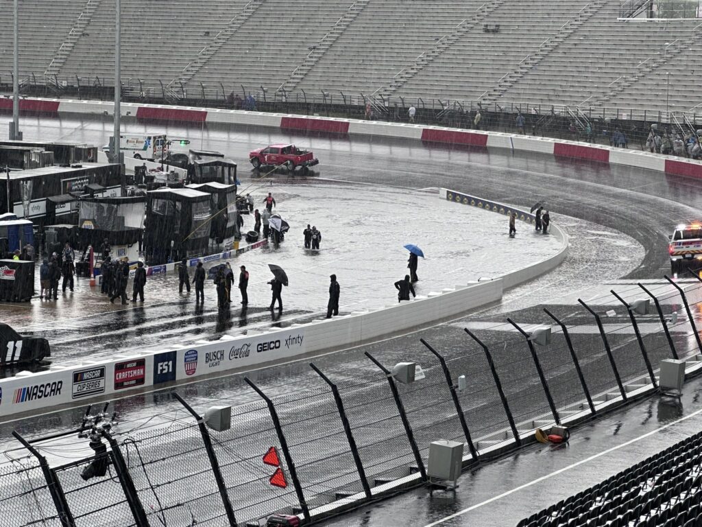
On Saturday, May 18, locally heavy rainfall put a damper on big events in the Foothills. The 3.97 inches of rain in Marion made for soggy fur at the Bigfoot Festival, while North Wilkesboro Speedway looked more like a lake than a racetrack during NASCAR’s all-star weekend. A nearby weather station on Rendezvous Mountain recorded 4.24 inches of rain – nearly an entire month’s worth of precipitation – in just four hours that afternoon.
May ended with more rain over Memorial Day weekend, including 3.19 inches for our ECONet station on Wayah Bald Mountain and 3.13 inches on Mount Jefferson.
For the month as a whole, Marion had 14.45 inches of rain and its 2nd-wettest May on record, trailing only the 15.76 inches in 2018. Hickory and North Wilkesboro also had their 2nd-wettest Mays, with more than twice their normal rainfall. Elsewhere, it was the 3rd-wettest May for Greensboro, the 4th-wettest for Mount Airy, and the 6th-wettest in Charlotte.
The lone dry spots in the state last month were along the central coastline, including Hatteras, which had its 28th-driest May in the past 131 years, and New Bern, which was 0.33 inches below normal in its 31st-driest May since 1948.
At the end of April, more than 60% of the state was classified as Abnormally Dry (D0) on the US Drought Monitor. However, the recent rains have almost wiped the map clean entering the summer. At this point, dryness remains only in a small pocket of far northeastern North Carolina where groundwater levels remain a bit below the historical median.
Warm Weather Helps Plants Advance
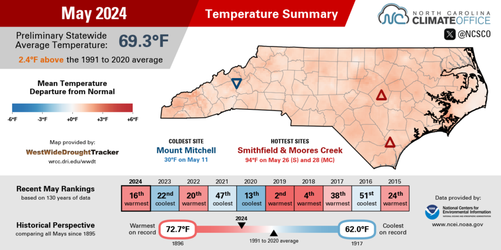
Summer arrived early this year in one of our warmest Mays on record. NCEI reports a preliminary statewide average temperature of 69.3°F, which ranks as our 16th-warmest May in the past 130 years.
A number of sites across the state had one of their top ten warmest Mays on record. It was the 7th-warmest May in the past 133 years for Asheville, the 8th-warmest in Raleigh, and the 9th-warmest for both Greenville and Lumberton.
While we saw frequent cold frontal passages last month to spur on our rain chances, those were cold in name only, and our temperatures were steadily in the upper 70s, low 80s, and beyond almost all month.
Our first taste of summer came early, with high pressure in place over North Carolina. On May 2, temperatures reached the 90-degree mark for the first time this year in areas such as Raleigh and Wilson. For Raleigh, it was the earliest 90-degree day since 2012.
On May 8, Greenville and Wilmington both hit 90°F for the first time. And with a similar high-pressure pattern over Memorial Day weekend, much of eastern North Carolina hit the 90s on May 26, with the mercury climbing to 94°F in Smithfield.
Weatherwise, this May was a world away from last year’s in North Carolina. May 2023 saw jet stream troughing and upper-level low pressure over the eastern US, which kept our temperatures below normal – on some days, barely making it out of the 50s – and entirely out of the 90s for most of the state.
While we’re sweating a bit earlier this year than we were last year, plants – including, perhaps, the hydrangeas in your garden – are also springing up faster and thriving this year thanks to the regular rainfall and unwavering warmth.
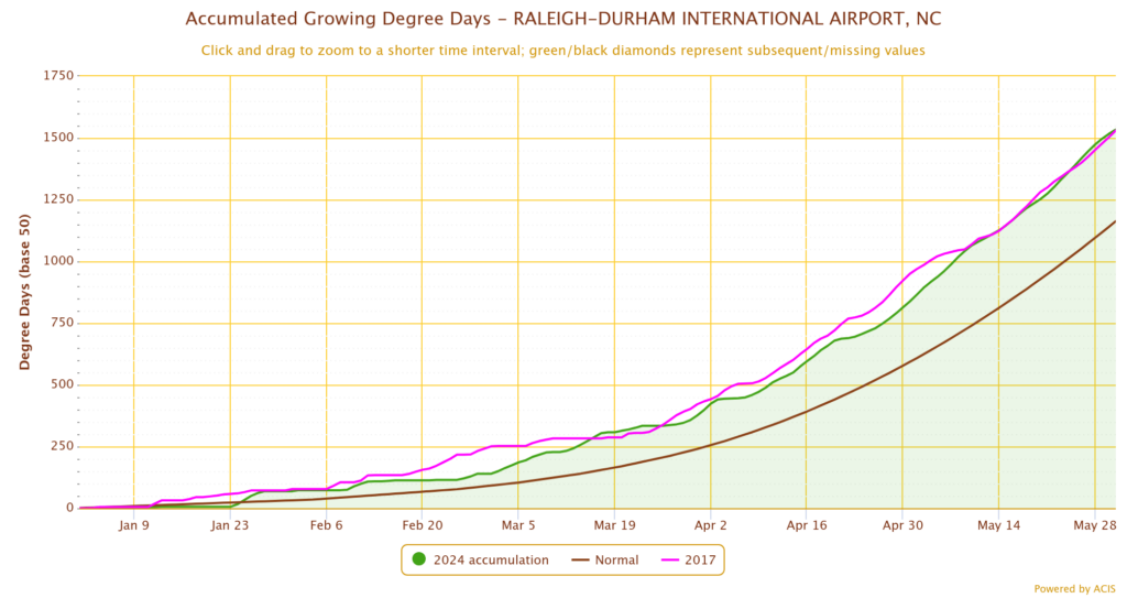
As daily average temperatures exceed a crop-specific threshold – for corn, a temperature of 50°F is typically used – growing degree days accumulate and track with that plant’s growth throughout the season. Farmers can therefore use this information to assess the development stage of their crops.
Through the end of May, Raleigh has accumulated 1,534 growing degree days so far this year. That’s almost 400 more than the historical average, and the most on record to this point, with our steady warmth throughout May helping us edge just ahead of 2017.
Our Spring in Summary
Along with that prevailing warmth, our variable rainfall patterns and a late surge in severe weather were all key characteristics of this climatological spring in North Carolina. Preliminary statistics from NCEI show that the past three months, from March through May, ranked as our 3rd-warmest and 28th-wettest spring season for North Carolina since 1895.
Dating back to late winter, when trees were in bloom two to three weeks earlier than normal, our temperatures have been consistently above normal in our 16th-warmest February, 16th-warmest March, 15th-warmest April, and now our 16th-warmest May.
There were few cold nights this season, and none below freezing for much of eastern North Carolina. The last night with temperatures at or below 32°F was on February 21 in Raleigh, February 22 in Wilson, and February 23 in Fayetteville. For all three sites, that is the earliest last spring freeze date ever recorded.
With that lack of cold, and ample warmth, this was a high-ranking spring in terms of temperatures. It was the warmest spring on record in Raleigh and Wilmington, the 2nd-warmest in Asheville and Greenville, and the 3rd-warmest in Charlotte and Greensboro, the latter of which tied 1991 and 2010 with a spring average temperature of 61.5°F.
Our precipitation seemed to change with each month during the season. Our state’s 28th-wettest March included heavy rainfall along the coastline, where it was the wettest March on record for Hatteras and Elizabeth City.
That was followed by our 13th-driest April, where many areas had barely an inch of rain, and Elizabeth City was the driest spot in the state, with only 0.55 inches all month. May reversed course again, putting us back into a wet pattern and ending the season with above-normal precipitation in most areas.
Lincolnton had its 6th-wettest spring out of 67 years with observations, while it was the 15th-wettest for Greensboro. And despite the month-to-month variability, Elizabeth City still ended with its 11th-wettest spring on record.
The few dry spots at the end of the season included Fayetteville, which was 0.18 inches below normal; Raleigh, which was 1.41 inches below normal; and Greenville, which was 3.01 inches below normal in its 21st-driest spring on record.
Our May showers also brought an active end to what started as a quiet season for severe weather. Statewide, there were no tornadoes in March and only two in April – our fewest to start a spring season since 2017.
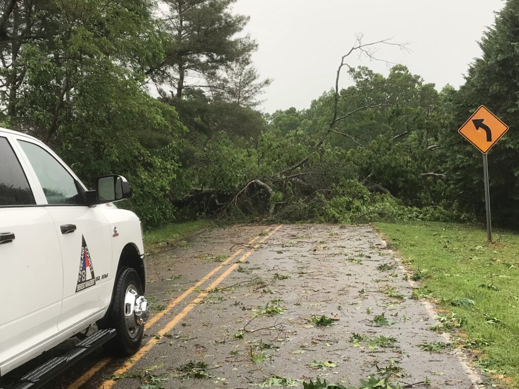
But May saw 11 confirmed tornadoes as part of three separate severe weather events that affected all three regions of the state.
On May 8 and 9, five total tornadoes touched down in the southern Mountains and western Piedmont, including a pair of tornadoes crossing through Gaston County and three rare mountain tornadoes in Cherokee, Jackson, and Buncombe counties. The Black Mountain tornado was the first in Buncombe County since May 6, 1999.
May 14 saw another five tornadoes target southeastern North Carolina, with three EF-0s in Robeson County near Pembroke, Red Springs, and Buie, plus a couple more in Columbus and Bladen counties. And May 24 saw an EF-1 along the coast in Onslow County that blew down trees on Camp Lejeune.
While our severe weather activity tends to decrease during the summer, we can’t rule out a few strong storms in this season. And as we previewed last month, the tropical Atlantic may have its own storms in store this year. If you missed that webinar with the National Weather Service in Raleigh, check out the blog post recap or the full recording.