
Warm weather dominated last month, and so did dry conditions across much of the state. In light of those unseasonable stretches, we look at how early spring has settled in this year.
Feeling Warm in February
Spring-like temperatures flourished in February, making it a warmer-than-normal month across the state. Preliminary data from the National Centers for Environmental Information (NCEI) puts this as our 16th-warmest February since 1895, with a statewide average temperature of 46.5°F.
That was 2.7°F above the 1991 to 2020 average, and right in line with recent trends. Six of our past seven Februarys have been at least 2 degrees warmer than that 30-year average, including our top three warmest Februarys on record in 2018, 2023, and 2017.
Most areas were 2 to 4 degrees above their normal temperatures last month, which was among the top ten warmest on record for parts of western North Carolina. It was the 7th-warmest February for Hickory and Lincolnton, and the 5th-warmest in Asheville.
The month included several unseasonably warm stretches, including a mid-month week with high temperatures consistently in the 60s and 70s. On February 10, with high pressure just offshore and warm southerly winds blowing in, temperatures topped the 70-degree mark in all three regions of the state.
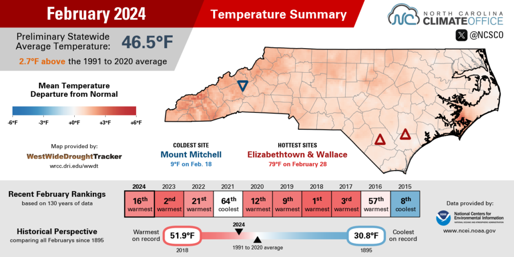
Asheville reached 72°F that afternoon, which was a full 20 degrees above normal. Raleigh climbed to 76°F and set a new daily record high temperature, breaking the previous record from last year. And New Bern heated up to 77°F – its second-warmest day of the year so far after hitting 81°F on January 26.
Our coolest day of the month came on February 18 in the wake of a cold frontal passage. High temperatures only reached the upper 40s in many areas, and several high-elevation mountain sites never made it above freezing, with the mercury at Mount Mitchell inching up to 19°F and Grandfather Mountain topping out at 25°F.
The warm weather returned for the final week of the month, including temperatures back in the 70s on February 26 and 28. Our ECONet stations in Wallace and Whiteville were among the warmest sites, each peaking at 78°F on February 28.
Even as Leap Day brought cooler and cloudier conditions to end the month, the preceding warmth was evident by then. Charlotte had 17 days all month with temperatures reaching at least 60°F, which tied for the 9th-most days that warm in any February on record there.
Dry Weather and Drought Return
The El Niño-fueled wet pattern from earlier this winter backed off in February, leaving us drier than normal in North Carolina. NCEI notes a preliminary statewide average precipitation of 1.64 inches and our 10th-driest February out of the past 130 years.
The wettest sites were in the far west, although even those areas finished the month with below-average precipitation. Highlands, for instance, had 4.99 inches in February, which was 1.92 inches below normal and a long way from its January total of more than 17 inches.
There were three notable precipitation events across the state last month. From February 11 to 13, a stalled low pressure system brought more than 2 inches of rain to southwestern North Carolina, including a three-day total of 3.20 inches at our ECONet station on Sassafras Mountain.
On February 23, a cold front brought another half-inch to an inch of rain in the southern and central Mountains. The month ended with rain showers between February 27 and 29, including 0.11 inches on February 29 at Hatteras – only the second Leap Day with measurable rainfall there, and the first since 1968.
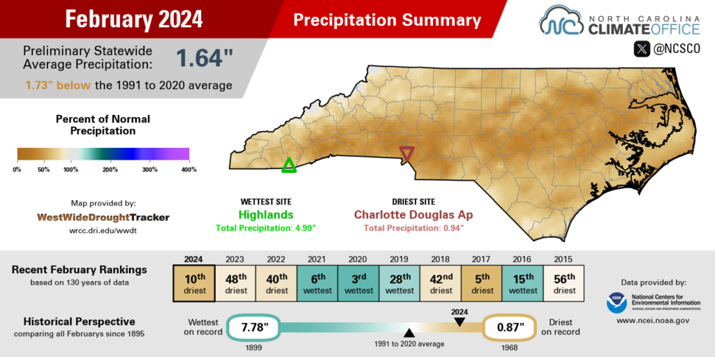
Much of the Piedmont and Coastal Plain had less than 2 inches of precipitation all month. The 0.94 inches of rain in Charlotte ranked as its 3rd-driest February on record, while with 1.65 inches total, it was the 5th-driest February for New Bern.
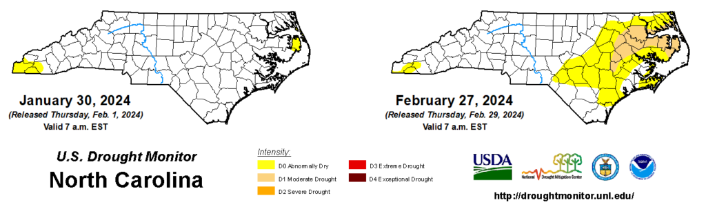
The onset of drier weather, combined with the warmer temperatures, ended a month-long break from drought conditions, as Moderate Drought emerged in parts of eastern North Carolina during the final week of the month. The main impact being observed for now is a decline in streamflow levels due to the limited rainfall recharge to rivers and streams in February.
While this drought is a new arrival, our long-running “snow drought” continued in February. Much of the state has now gone more than two years since the last measurable snowfall in January 2022, and barring a rare March snow, both Asheville and Charlotte will set a new record-long snow-free streak later this month.
Even in the Mountains, snow was hard to come by last month. Mount Mitchell had just one snow event, with 1.8 inches on February 25, compared to a monthly normal of 18.6 inches. At our state’s highest point, it has been a lackluster season, with only 32.4 inches of snow since October 1 – the 4th-least in a winter there since 1980.
Tracking Spring’s Progress
Garner’s own groundhog forecaster, Snerd, was spot-on with a prediction of an early spring this year. But just how early has the arrival of our spring-like weather been? We can measure the timing of this seasonal switchover in a few different ways, but they all offer a similar answer.
One is simply comparing our recent temperatures to the 30-year climate normals. Over the final week of February, our average high temperatures ranged from the upper 50s – including 59°F in Greensboro – to the mid-60s, with a weekly average of 64°F in Charlotte, Lumberton, and Wilmington. In each of those areas, those temperatures are more typical of the second week of March, meaning they’ve showed up about two weeks earlier than normal.
Growing degree days – which accumulate throughout the year as daily average temperatures exceed a crop-specific temperature threshold, often around 50°F – are a useful way for farmers to track the development of crops through various growth stages.
At the end of February, our ECONet station in Clayton at the Central Crops Research Station had measured 124.2 growing degree days so far this year. We typically hit that level on March 9, which also puts this year 1 to 2 weeks ahead of schedule. (For more information about our ECONet and its applications, including for agriculture, join us for our ECONet Overview Webinar on March 18 at 10 am.)
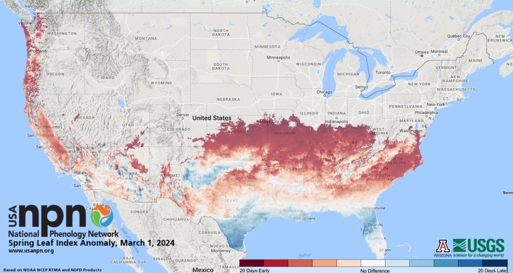
Finally, the National Phenology Network uses temperature data and mathematical models of lilac and honeysuckle to track the first leaf-out and bloom dates across the country. Their maps show that leaf-out of these early-emerging species is happening 15 to 20 days earlier than normal across eastern North Carolina.
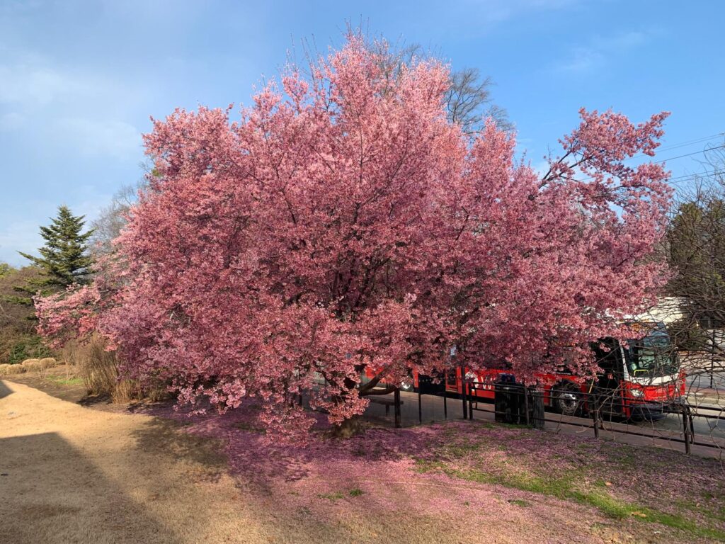
Each of those indicators points at spring arriving one to three weeks early this year. Of course, you can see this progression for yourself with trees budding – including beautiful pink cherry blossoms – and flowers continuing to pop up across the landscape.
While these signs of spring, combined with the recent warmth, might encourage you to get your garden planted now, remember that we’re still about a month away from the average last spring freeze dates in most areas. The recent 30-year average shows that last freeze date happening on March 26 in Fayetteville, March 30 in Charlotte, and April 3 in Raleigh.
Many crops can withstand short periods of freezing temperatures, particularly with protection such as row covers, but more sensitive species and flowers can easily suffer frost or freeze damage. Extreme cases with prolonged cold snaps such as the Easter freeze in 2007 can even have a significant impact on seasonal yields.
So while our current weather makes it awfully tempting to plant early, the ever-present climatological freeze risk in March and early April, and our recent history of exactly such a season-disrupting event, might make you think twice, especially if Old Man Winter decides to make another appearance in North Carolina this spring.