Florence After Five: Inundated Ecosystems

This is the third in a four-part blog post series remembering Hurricane Florence for its five-year anniversary.
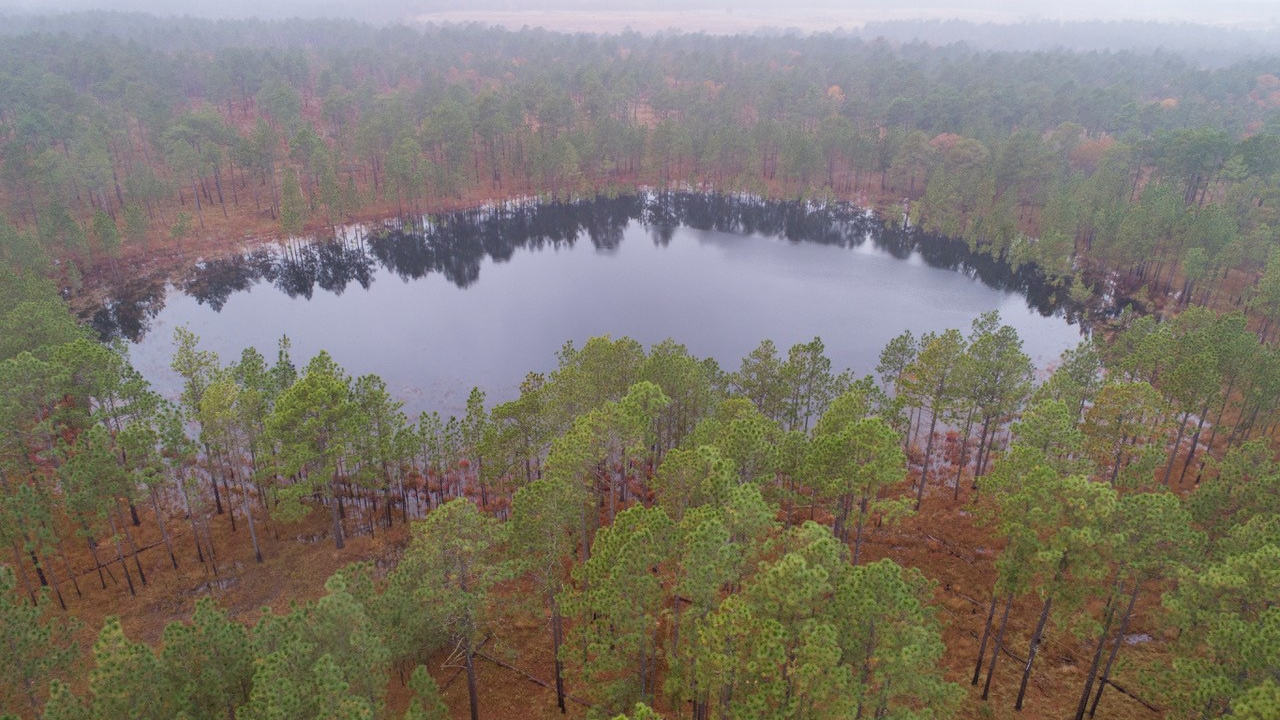
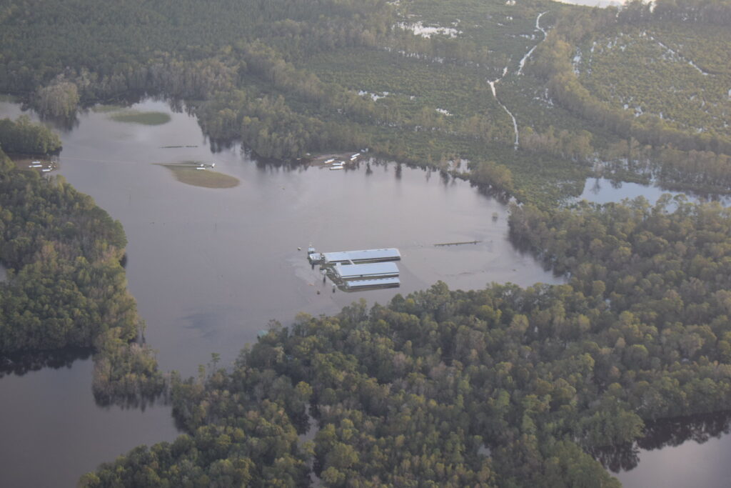
More than 100 miles from the ocean, a small pond in the Sandhills exemplifies the significant and sustained impact Hurricane Florence had on the natural landscape, long after the winds and rain were finished back in September 2018.
In the Sandhills Gameland, just off US Highway 1 in Richmond County, an unassuming circular depression in the earth has great ecological value, which is apparent in its name: 17-Frog Pond, a reference to the diversity of amphibian species that breed there.
This area is classified as an ephemeral isolated wetland because it’s not directly connected to other water sources such as rivers, but it fills during the winter and dries out during the summer.
Or at least that’s how it’s supposed to be.
A Pond’s Progression
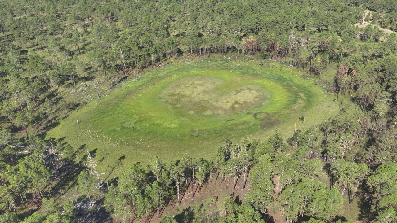
For almost four years following Florence, there was water in the pond year-round, and it took until last summer for the typical seasonal cycle to return.
That prolonged disruption gave biologists such as Jeff Marcus, the longleaf applied scientist with the North Carolina chapter of The Nature Conservancy, and gameland staff such as Mike Martin with the North Carolina Wildlife Resources Commission, a chance to assess the storm’s longer-term impacts.
At first, the abundance of water was a positive for the local amphibians.
“There was a flush of breeding activity from gopher frogs, tiger salamanders, and other species immediately after the hurricane,” said Marcus, who noted that it was difficult to precisely quantify the activity because the water was too deep even to navigate with chest waders, and in later years, the standing water became tannic with poor visibility.
After Florence, Martin said he observed larger tadpoles and suspects it was due to the longer hydroperiod – the time in which the pond held water – that allowed them to grow bigger and stronger before leaving the pond.
But those multiple years with standing water also killed off herbaceous land cover and prevented the germination of new grasses – to which frogs attach their egg masses, and tadpoles use for cover and food – so the overall habitat quality declined. The water quality also took a hit as sediments and chemicals, even if highly diluted, washed in after the storm.
As 17-Frog Pond became interconnected with nearby creeks, that allowed predators to move in and feast on the frogs. At least one otter found its way to the pond, Marcus said, and at another isolated pond, Martin saw chain pickerel – a fish species native to the nearby Pee Dee River and Drowning Creek, but not to 17-Frog Pond.
“Not surprisingly,” said Marcus, “the answer to the question of whether Hurricane Florence was beneficial or detrimental for pond-breeding amphibians is ‘it’s complicated’.”
But he and Martin both added that while heavy rain events like this can have benefits for species, such as making it easier for them to disperse across the uplands and find new breeding sites, that is also heavily dependent on the weather in the following spring.
And with increasing variability under climate change, such as more intense rainfall events followed by prolonged dry spells, that’s making conditions in areas like 17-Frog Pond less predictable for humans and animals alike.
Wetlands Under Threat
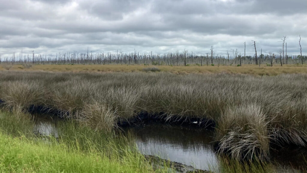
Farther east, some forested coastal wetlands have been damaged both by recent storms such as Florence and the insidious encroachment of the ocean since then.
It’s a one-two punch threatening these ecosystems, which offer an important and beneficial natural barrier between land and sea.
“They provide good protection that’s relatively cheap compared to building a seawall or hard infrastructure,” said Dr. Marcelo Ardón, an associate professor in the Department of Forestry and Environmental Resources at NC State University.
Ardón studies these wetlands and their changes, which are often most pronounced after hurricanes.
“With a storm like Florence, you have the wind damage, and also increased flooding from all the rain,” he said. “The combination of those two can affect these coastal wetlands and cause tree mortality and the loss of leaves and canopy, which also affects the health of the trees.”
Research at the University of Virginia and Duke University found that across the North American Coastal Plain from Texas through Maine, the number of tropical storm impacts was a leading indicator of the loss of forested wetland area.
That same study noted that the lower Pee Dee River basin – the same region inundated repeatedly during Florence, Matthew, and the October 2015 rain event – led the nation with 405,000 acres of forested wetland lost between 1996 and 2016.
After storms, the recovery for forested wetlands is slow at best.
“Those things will have long ramifications,” said Ardón. “When you have an event that causes a lot of trees to fall over, that can last for decades. It takes a lot of time for other trees to fill in those canopy gaps.”
When the flooding is bad enough, as with Florence, recovery may not be on the table for some wetlands, instead pushing them toward a more eerie fate.
“If you have sustained flooding for a long period of time, you can have tree mortality and the formation of ghost forests,” he added.
As salinity levels in these wetlands increase, vegetation such as trees can’t take up oxygen as easily, while high water levels over a long period of time can starve the roots of oxygen, which eventually kills those forests.
Researchers in the Albemarle-Pamlico peninsula in eastern North Carolina found that the rate of ghost forest formation was greatest immediately after Hurricane Irene in 2011 due to the wind and storm surge pushing salt water over the land.
Other research within the Cape Fear Estuary – the 35-mile section of the river between Wilmington and the Atlantic Ocean – found that along some stretches, more than 40% of forested wetlands were lost or converted to marshlands between 1964 and 2018, with the greatest changes occurring since 1998. Rising water levels, such as those caused by tropical storms, were cited as a key factor.
In addition, the boundary of the forested wetlands has been shifting upstream by the length of up to four football fields every year, on average. That steady shift over time means the impacts of storms are being absorbed less by wetlands and felt more strongly farther inland.
“The marshes get the brunt of the storms, but they’re very good at attenuating those waves,” said Ardón. “But as we’re losing those marshes, the forested wetlands are more vulnerable, and we’re losing some of that protection.”
While the fury of a single storm, with a surge measured in feet, may seem to far outweigh the contribution of sea level rise, which is happening at about another inch every two years in Wilmington, Ardón said both are having an impact.
“Sea level rise is a slower change, but it increases the baseline, and as that baseline gets elevated, it compounds or makes those storms a lot more impactful for these ecosystems.”
It’s also a reminder that even the five years since Florence haven’t given our coastal wetlands a break from the changes happening in and around them.
Farmers Face Florence
During our worst storms like Florence, the impacts on the natural environment have carried over to the human-curated landscape, particularly for the farmlands that dominate eastern North Carolina.
While farmers had experience with flooding and wind damage from storms such as Fran, Floyd, and Matthew, few could anticipate how much worse Florence would be.
Sure, they had learned a thing or two about how to prepare for a storm at that time of year, near the end of the growing season: checking generators, getting fuel, topping off feed bins for animals. And pulling any crops they can out of the ground.
“When there’s a storm pushing down on us like that, they’ll go ahead and pick corn, use a drier system to get it dry, and you’ll see the trucks loaded down to get everything out that they can,” said Della King, the field crops extension agent in Duplin County.
But ironically for such a slow-moving storm as Florence, the surprise for farmers was the speed at which conditions deteriorated.
King’s colleague Amanda Hatcher, the Duplin County extension director and livestock agent, recalls hearing from farmers who were caught off guard by the fast-rising water.
“One farmer had to spend most of Florence on the farm to finish up some loose ends,” Hatcher recalled. “By the time he got ready to leave, the creek had run out of its banks so he couldn’t leave home.”
That farmer rode out most of the storm in a pump house. Another farmer and his wife found themselves in the same situation, and when the roof on the pump house was damaged, they escaped to their truck with the rain falling and the water rising around them.
Downstream along the Northeast Cape Fear River, it was a similar story in Pender County with widespread flooding on farms. County Extension Director Mark Seitz said it was a consequence of the flat land and the prevalence of water throughout the county.
“Almost every acre of tillable cropland is close to a creekbed somewhere,” said Seitz.
In Florence, water flowing down the rivers and being pushed inland by the wind converged in Pender County.
“At high tide, it just bottles up,” he noted. “There’s nowhere for it to go so it just spreads out across the land.”
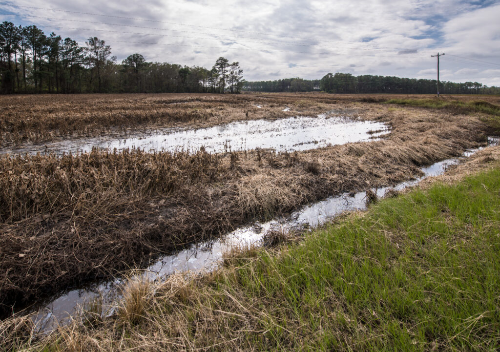
While the scenes of a submerged Interstate 40 were attention-grabbing, the impacts were much longer-lasting on the surrounding farms throughout the county.
“The aftermath was just awful,” said Seitz. “It was about 15 days of flooding before the water level came down.”
That meant blueberry bushes were completely submerged and soybeans were laid flat by the winds, then covered by the water. Seitz said a test plot was in line to produce 60 or 65 bushels of soybeans per acre before Florence, but afterwards – once the beans were finally picked in early December – it only yielded about 20 bushels per acre because so many had rotted on the vines.
Because of the duration and extent of the flooding, farmers also found themselves running low on needed supplies, with feed trucks unable to get in and the county’s fuel depot in Wilmington cut off by road. Even hay bales saved up before the storm were largely unusable afterwards as mold and mildew set in.
Seitz’s role after the storm was one of logistical coordination, on the phone with the state Emergency Operations Center to arrange hay pickups and deliveries to farms via high-wheeled trucks that could negotiate the high water.
In Duplin County, the storm’s lingering impacts could be seen – and smelled – for weeks, as extension agents discovered while assessing crop and structural damage on farms throughout the county.
“You could smell the sweet potatoes rotting in the ground because the water had sat on them for so long,” said Hatcher.
Even getting the fields ready for the next growing season was difficult. Water sat on some hay fields for so long that the bermuda grass was killed and never regrew. And the hydraulic pressure of the water caused soil compaction that Hatcher said made it tough to get those fields back into production.
“The New Benchmark”
For farmers in eastern North Carolina who had suffered their third flooding hurricane in a 20-year period, Florence stood out as the worst of the bunch.
“This is the new benchmark for them,” said Hatcher. “Floyd was, and now Florence has moved ahead of Floyd.”
King, who has spent most of her life in and around Duplin County, remembers storms like Fran and Matthew washing out roads and dams, but Florence went a step beyond either of those.
“We’ve never seen that much flooding compared to previous hurricanes,” she said. “The water stayed around a lot longer and didn’t dissipate like it did with Matthew.”
While widespread flooding may be unavoidable from a storm the scale of Florence, Matthew, or Floyd, those flat eastern counties have taken steps to improve their response.
King said with help from Duplin County emergency management, the sheriff’s office and volunteer fire departments now have surplus military trucks that can drive through flooded areas to aid in rescue efforts. The county also added a rescue squad on the eastern side of the Northeast Cape Fear River since those areas lost access to the closest large towns.
“We had so much flooding coming toward us, we were logistically cut off from Wallace and Kenansville, where the hospital and doctors offices are,” said Hatcher.
She is also proud of how her county extension office has worked with groups like the Natural Resources Conservation Service, the county Soil and Water Conservation Office, and the Farm Service Agency to provide information and assistance in the wake of storms.
“That represents a lot of strength for our farmers and our citizens to know that their agencies really work together to help as many people as possible,” she added.
Five years after Florence, plenty of vulnerabilities remain, and the options for addressing those aren’t always clear-cut.
Seitz said Pender County made a push to update their floodplain maps, but some farmers worried that would affect whether land could be used for crop production – and continuing their own livelihoods.
“You obviously don’t want to rebuild houses in places that are known to flood or make the requirement that the house has to be elevated – and that’s what the county was trying to do to minimize future impact – but at the same time, peoples’ lives move on,” he explained.
He has also seen that the repeated hits from storms like Florence are testing the ability of farms – and farmers – to bounce back like they always have.
“Farmers are pretty resilient,” he said. “They don’t sit around and wait for the repairman to come.”
“But when you get a storm like Florence, there just isn’t anything you can really do. You can plan and put stuff up on shelves and hope the roof stays on, but at the end of the day, if a storm like that hits you, you’re going to take a blow to the wallet, a blow to the ego, a blow to your perspective on the world.”
Among the signs of folks facing those realities, some families in the county have received property buyouts from FEMA to get them out of flood-prone areas, and others are still waiting on those determinations.
And that’s not the only lingering reminder of Florence.
Away from the farms and back in the forests, Seitz said Florence filled timber stands with a sludgy mixture of flood water, gasoline, septic waste, and organic matter.
“It was like soup where it stagnated, and when it receded, it stuck to the trees,” he said.
Even today, while driving down the once-flooded stretch of Interstate 40 through Pender County, Seitz said a carefully trained eye can still pick out the shadow marking where the water rose to new record levels in the trees along the river.
- Categories:


