After a couple of lackluster winters in a row — and with an outlook that doesn’t exactly scream “snow days on the way!” — the flakes feel fleeting and snow seems scarce across North Carolina.
By opening up the historical records, we can see just how long it’s been since significant snow fell in different parts of the state, and some areas have had a long wait for more of the white stuff.
Using weather station observations, CoCoRaHS reports, National Weather Service analyses including NWS Raleigh’s events archive, and even satellite-based daily snow surveys, we pieced together the maps below showing our most recent 1-inch, 6-inch, and 12-inch snowfalls.
You can read these maps like paint on a canvas, with each new brush stroke covering up the ones beneath it. The most recent events, shown in blue, obscure the older ones in green, yellow, and brown. Together, they show our historical snow events layered across the state.
An Inch, in a Pinch
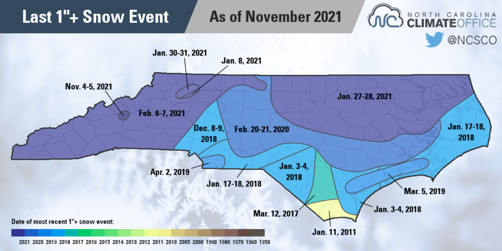
Let’s start on the low end with an inch of snow: enough to cover the grass, but slim pickings for building a snowman.
In some areas, this much snow has already fallen this season! Mount Mitchell measured 1.8 inches of snow on November 5.
Dating back to last winter, the February 6-7 event this year brought at least an inch to most of western North Carolina, aside from parts of Wilkes County whose last inch of snow came a bit earlier, in January.

The northeastern Piedmont and northern Coastal Plain also had an inch or more last winter during an event on January 27-28. In that event, totals of up to 5 inches were recorded in Roxboro.
Farther south, it’s clear just how uncommon snow has been recently. Most of the southern Piedmont and Outer Banks last received at least an inch during a trio of events in 2018 — almost four years ago in some spots.
Parts of Bladen and Columbus counties haven’t seen an inch since March 12, 2017, but the longest snow drought belongs to our far southern coastline. Much of Brunswick County, including Ocean Isle Beach, Holden Beach, and Bald Head Island, last picked up an inch of snow back on January 11, 2011, more than a decade ago!
Add Six in the Mix
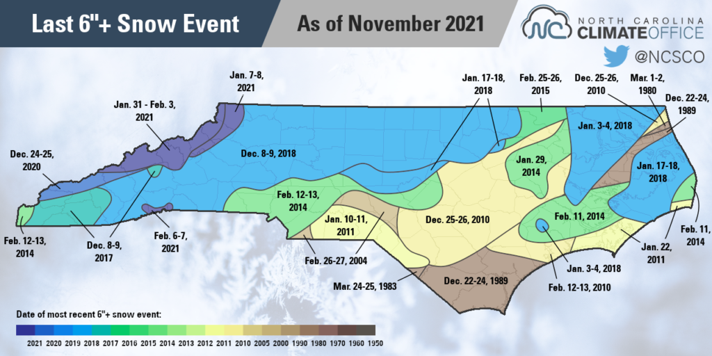
Six inches represents a years’ worth of snow or more falling in most areas, so individual events packing this much snow are decidedly less common. Even some snow-prone parts of the Mountains haven’t had six inches in an event in almost three years, since the December 8-9, 2018 storm.
That event dominates the map in the northern and western part of the state, while a pair of other 2018 storms — on January 3-4 and January 17-18 — show up across the central Piedmont and northern Coastal Plain.

Charlotte last saw six inches in a single event almost eight years ago, on February 12-13, 2014. For Fayetteville and much of the I-95 corridor, the last time they saw six inches on the ground was during the Christmas storm in 2010.
Pockets of the Coastal Plain have to go even further back to find their last six-inch event. For Wilmington and the southern coast, that came during another Christmas storm from 1989. And a small sliver of the northern coast along Pine Island last received six inches of snow more than 40 years ago on March 1-2, 1980.
Put Your Foot Down
Now we’re talking serious snowfall. A foot of snow is enough to shut down cities for a week. It’s what kids dream of, but for most children in the state today, it has only ever been a dream.
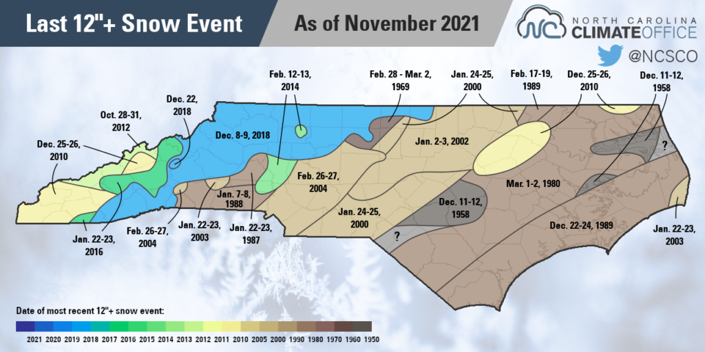
The main exception again comes in the north and west, where the December 2018 storm delivered a foot of snow to much of the Mountains and northwest Piedmont. Ten years before that, Charlotte picked up 13.2 inches in a February 2004 storm across the western Piedmont.
A few other curiosities on this map include the late October 2012 snow in the Mountains associated with Hurricane Sandy, and that the 20”+ snow in January 2000 actually isn’t Raleigh’s most recent foot; that honor goes to the January 2002 storm across the Triangle.
Perhaps the most intriguing parts of this map, though, are the areas that haven’t seen a foot of snow in decades. The rarity of events this large means that some unlucky locales will inevitably miss out on their limited opportunities, yielding long gaps since their last blockbuster snowfall.

That includes downtown Greensboro. While the official observing station at the airport recorded 12.8 inches in the December 2018 event, central Guilford County only received around 11 inches from that storm. Recent decades offer a number of similar near misses, so to find a foot of snow there in the historical records, we have to go back to early March 1969, when 12.5 inches blanketed the Gate City.
Meanwhile, Fayetteville and a few other parts of eastern North Carolina have gone almost 63 years — since December 1958 — without seeing a foot or more in a single event.
This map even offers a few mysteries, as in small parts of the Sandhills and northern Outer Banks, none of the available data dating back almost 100 years definitively shows a 12-inch event occurring there.
A now-decommissioned weather station in Kill Devil Hills reported a total of 13.7 inches during a December 1943 storm, but nearby Manteo had only 9 inches in that event, so some or all of this narrow stretch of the coast likely traces their foot-of-snow drought at least this far back.
Laurinburg and surrounding parts of the Sandhills have had a few close calls, including 9 inches in March 1980 and 11 inches in February 1973, but no events exceeding a foot show up in its dataset going back to the early 1940s.
The best candidate for that part of the state may be an early March 1927 storm that brought 24 inches to Fayetteville but only 7 inches in nearby Lumberton. That sharp snowfall gradient may ultimately mean that parts of Scotland and Robeson counties have to go back more than a century to find their last foot of snow.

So what lessons can these maps teach us?
If you’re a snow lover, they probably don’t inspire much hope since parts of the state have never seen a foot of snow in your lifetime.
However, the more recent December 2018 storm also shows that significant widespread snow is still possible, given the right set of atmospheric ingredients.
Digging deeper, we also see that you don’t need a roaring El Niño to produce a decent snowfall. In fact, some of the most common years on these maps were in a neutral ENSO phase, such as 2003-04, or even a La Niña, such as 2010-11.
Of course, that’s no guarantee that this La Niña winter will produce similar snowfall results, but it’s always a possibility. And it only takes one storm to produce a fresh new brushstroke of snow, perhaps even ending some long-running waits for the next big blizzard.