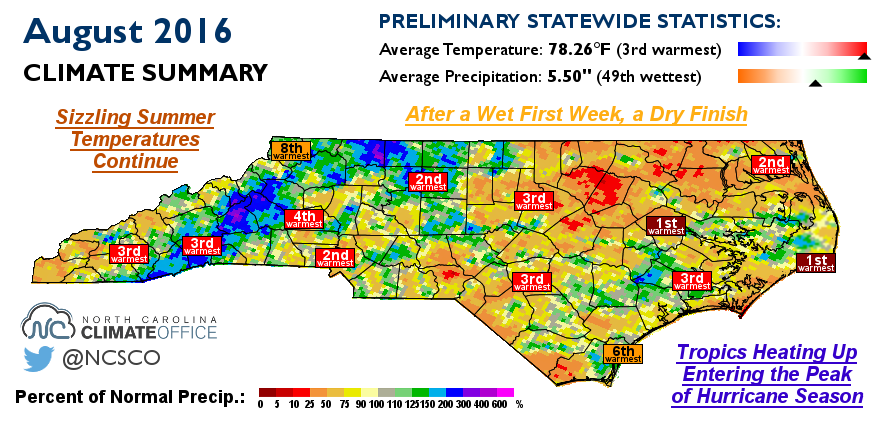
Above-Normal Temperatures Continue in August
Again in August, we couldn’t escape the ongoing summer heat, and conditions dried out as the month went on.
Sizzling Summer Temperatures Continue
The meteorological summer wrapped up with another month of above-normal temperatures. The statewide average temperature of 78.26°F ranks as the 3rd-warmest August since 1895. The only years with warmer Augusts in North Carolina were way back in 1900 and, more recently, in 2007.
The main culprit behind the heat was a persistent ridge in the jet stream over the eastern US. A southwesterly flow kept warm, humid air in place across most of the Southeast. There was little escape from the heat, as all reporting sites across the state had one of their top ten warmest Augusts on record. Notably, Hatteras had its warmest August out of the past 122 years and Greenville had its warmest August in the past 88 years.
Our August temperatures largely followed the same pattern as in July, with persistent warmth but few days of extreme heat. Raleigh and Charlotte had 23 and 25 days, respectively, with high temperatures reaching 90°F or higher. That ranked as the second-most number of days that warm in August at each site. So far this year, Charlotte has observed 68 days reaching 90°F or above, which ranks as the fourth-most out of the past 137 years.
Despite having many days in the 90s, only one site reached the 100 degree mark all month: On August 15, Fort Bragg hit 100°F. With 100-degree heat exceedingly rare in September, it’s likely that most sites will finish the year without hitting 100°F, although the unrelenting heat all summer made that achievement of little consolation.
After a Wet First Week, a Dry Finish
The statewide average precipitation of 5.50 inches ranks as the 49th-wettest August out of the past 122 years. However, that number is potentially misleading, as much of the month and most of the state was far from wet.
Almost half of that rain — 3.47 inches, averaged across the state — came during just the first nine days of the month. After that, the faucet switched off and the rest of the month was particularly dry. The contrast was impressive: For one, Statesville picked up 10.36 inches in the first week of August and just 0.85 inches over the next three weeks. While the eastern slopes of the Mountains and parts of the Triad did see some late-month rainfall, most of the state received less than two inches of rain over the final three weeks of August.
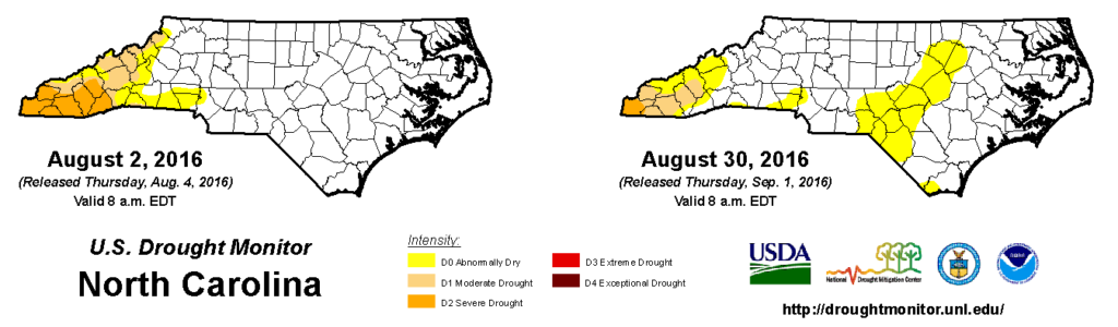
That rainfall did help abate Moderate Drought conditions in Asheville and points northward, but the dry, hot weather elsewhere saw Abnormally Dry conditions expand to cover the Sandhills and parts of the eastern Piedmont. If you’ve seen wilted or brown grass in your yard, that’s a good indication of the recent dry weather.
Our next batch of rainfall may not be too far away, though, as activity in the tropics headed in our direction could mean a wet start to September.
Tropics Heating Up Entering the Peak of Hurricane Season
A quiet summer in the Atlantic has come to a close with a recent spate of tropical systems. While Fiona and Gaston stayed away from the mainland United States, that was not the case two more recent developments.
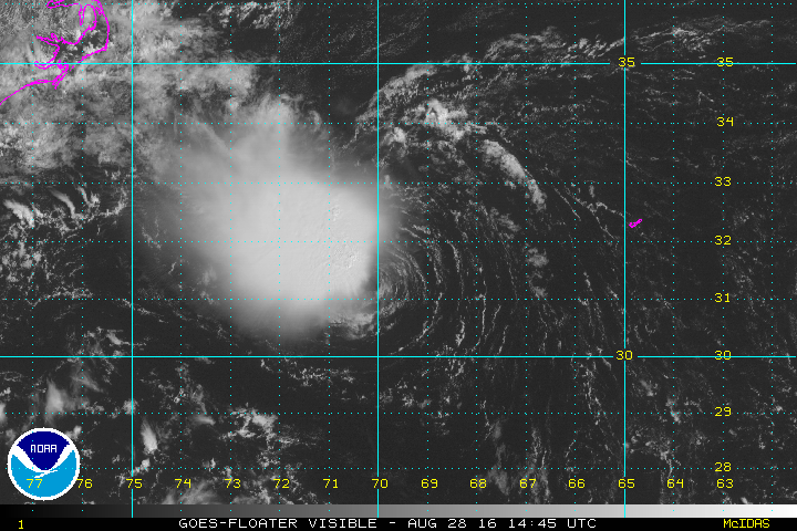
The month of August wrapped up with Tropical Depression #8, which drifted toward the North Carolina coastline, generating high surf and some gusty winds. The Outer Banks also picked up 1 to 2 inches of rain before the tropical system turned back out to sea.
At the same time over the Gulf of Mexico, Tropical Depression #9, which was named Tropical Storm Hermine yesterday afternoon, slowly drifted northward over the warm Gulf waters. At the time of publication of this blog post, Hermine was expected to make landfall along the Florida panhandle early tomorrow (September 2) and skirt the southeast coast over the Labor Day weekend.
The National Weather Service predicted more than six inches of rainfall, as well as high wind gusts and possible isolated tornadoes, across parts of eastern North Carolina. As this event unfolds, stay connected to the National Hurricane Center and your local National Weather Service office for updated forecasts and watches or warnings as they’re issued.
Is this recent tropical activity a sign of things to come? With the climatological peak of hurricane season less than two weeks away, this is certainly the time of year when we expect to see storms form.
At the moment, one barrier to formation is sand and dust from the Sahara Desert in the air over the eastern Atlantic. That doesn’t mean that storms won’t form, but it may mean they won’t develop until they get past that region where atmospheric moisture is sapped by the dust.
Along with tracking tropical systems over the coming weeks, we will also be taking a look 20 years in the past to remember Hurricane Fran. Stay tuned to the blog next Tuesday as we cover Fran and its impacts, including stories documenting the damage from around the state.
- Categories:


