March of 1960 must have felt a bit like Groundhog Day in North Carolina. For the first three Wednesdays of the month, parts of the state saw snow or ice as part of a rare early-spring string of wintry weather.
Prior to March, the winter of 1959-60 was quite unremarkable in North Carolina. Mean temperatures through December, January, and February were right at the long-term average. Neutral ENSO conditions provided little large-scale atmospheric support for abnormally wet or dry weather, so the first half of winter saw near-normal precipitation as well.
However, by late January, a different atmospheric pattern — the North Atlantic Oscillation — entered a negative phase, indicative of a polar jet stream pattern that was favorable for cooler weather and snow.
The season’s first bout of snow came on Valentine’s Day weekend, with more than a foot of snow in parts of western North Carolina. That event was part of a cool, wet February, and it set the stage for more of the same in March.
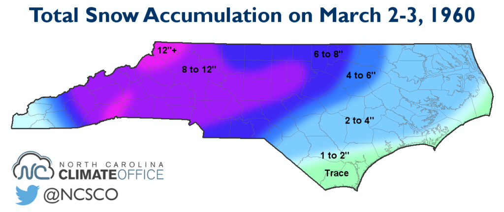
First Wednesday: March 2
A persistent wintry pattern took shape in early March as an Arctic air mass over the northern Plains spilled eastward, dropping temperatures into the 20s and 30s across North Carolina to begin the month.
While the cold air settled in, a low pressure system developed over the Gulf of Mexico and moved inland, and a second low formed west of the Mountains. Both lows brought in plenty of moisture to the tune of 1 to 3 inches of liquid precipitation, much of which fell as snow.
The snow began first in the Mountains in the early morning hours of March 2, with Raleigh seeing the first flakes by noon. The snow was heavy at times, and accumulations exceeded 6 inches in the Mountains and Piedmont, including 9.5 inches in Charlotte.
Eventually, most locations transitioned to sleet, freezing rain, or — along the immediate coast — liquid rain before tapering off early the next morning. The slick conditions caused numerous traffic accidents, including one resulting in a fatality.
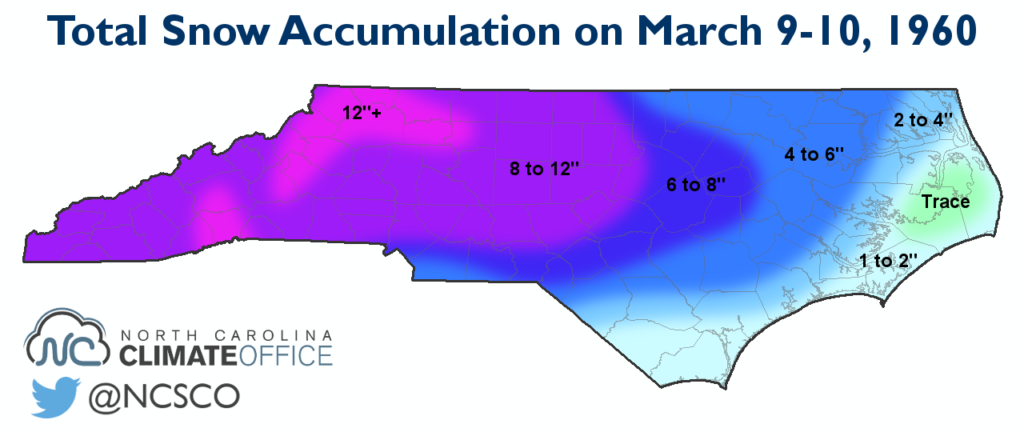
Second Wednesday: March 9
The following Wednesday, a similar setup brought another round of statewide snow. High pressure to the northwest pushed cold air in place, and a pair of low pressure systems — one to the west and one over the Gulf coast — brought in more moisture.
Snow began falling just after sunrise on March 9 and again accumulated rapidly. Locations west of Interstate 95 received more than 6 inches of snow. Charlotte nearly mirrored its total from the previous week with 9.8 inches, while Greensboro reported 11.1 inches and Asheville had 14.4 inches.
As in the previous Wednesday’s event, precipitation eventually transitioned to sleet or freezing rain before it ended the next morning. No deaths were attributed to this event, but several hundred injuries were reported.
That event was followed closely by another one on Friday, March 11. This time, a low well offshore brought the immediate coast its most significant snow of the winter. Wilmington received 7 inches and Hatteras received 9 inches.
The Mountains also saw several inches of additional snow, and snow depths of 3 feet with drifts of up to 30 feet were reported in some places.
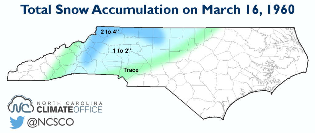
Third Wednesday: March 16
The third Wednesday of March saw yet another round of wintry weather. Another low moved up the coast on March 16, but this time, the result was an ice storm for the western half of the state.
Surface temperatures hovered near freezing throughout the event, with slightly warmer temperatures and mostly rain falling along the coast. Precipitation began as light snow across the Mountains and Piedmont with minor accumulations, but as temperatures warmed aloft, the precipitation changed over to freezing rain.
Impacts were greatest in the western Piedmont, as Charlotte, Greensboro, and points in between saw much of the three-quarters of an inch of precipitation fall as freezing rain. Ice accumulations on roads, trees, and power lines made for hazardous conditions across the region.
A Record-Setting March
By the end of March, high temperatures finally crept back above normal, but the nearly four weeks of cold, wintry weather left their mark on the month. The average statewide temperature of 37.24°F ranks as the coldest March on record going back to 1895, and is more than 12 degrees below the historical average.
The persistence of such cold temperatures may be even more impressive. Most locations around the state had below-normal mean temperatures for the first 27 days of the month, with temperatures up to 28 degrees below normal when cold air and snow moved in on March 9.
The snowfall that March was more than double the normal wintertime totals, and 1959-60 ranks as the snowiest winter on record for Asheville (40.6 inches), Greensboro (31.7 inches), and Charlotte (22.6 inches), with much of that snow coming after the end of meteorological winter.
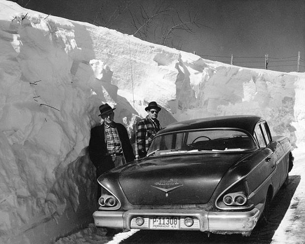
Snow stayed on the ground for more than two weeks across much of the state. At least one Triad resident remembers going outside and kissing the ground once the snow finally melted.
A.V. Hardie, the then-state climatologist with the the US Weather Bureau in Raleigh, noted that “[t]he unprecedented quantity of snowfall and duration of heavy snow cover in western North Carolina caused widespread hardship and considerable economic loss.”
A weather observer in Tryon in the southern mountains put it much less diplomatically.
“This is by far the worst March ever experienced here,” he wrote. “Most snow, most cold, most everything bad. Groundhog could do better.”
Sources:
- A Review of the Record-Breaking Snow and Persistent Cold of February and March 1960 by Laurence G. Lee, NWS Greer