This post is part of a series highlighting the summer projects from our offices’ undergraduate research assistants. The fifth part of this series is by Andrew Martin, a senior majoring in Meteorology at NC State.
Have you ever been delayed at the airport because of weather? According to the Research and Innovative Technology Administration (RITA), weather accounts for between 33.7% and 49.9% of total delay minutes per year. Weather in of itself doesn’t mean delays so much as poor visibility for take off. The Federal Aviation Administration (FAA) sets minimum visibility requirements for departing flights, and for most major airports, pilots operating under visual flight rules must have visibility greater than three statute miles (a statute mile, or SM, is the straight line distance between two points on land) before they can take off.
To determine visibility, most high-traffic airports have automated weather observing systems that record hourly conditions, aptly named Automated Surface Observing Systems (ASOS) or Automated Weather Observing Systems (AWOS). Both systems are a collection of electronic sensors providing information to a computer that creates minute-by-minute observations for pilots and other users.
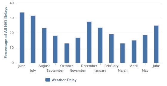
The National Oceanic and Atmospheric Administration (NOAA) defines visibility as the greatest horizontal distance an observer can see and identify a prominent object. Visibility is often lowest early in the morning or after rain and thunderstorms move through. This is evident in the graph to the right that shows weather caused nearly a third of Raleigh’s airport delays last June and July — one of the prime times of year for afternoon showers and storms.
The ASOS visibility sensor does not directly measure how far one can “see”. Instead, it measures the clarity of the air. To measure visibility, it projects light in a cone-shaped beam and measures the return every 30 seconds. The more moisture, dust, snow, rain, or particles in the light beam, the more light is scattered. Special observations are issued to alert users at visibility less than 3 statute miles and visibility less than 1 statute mile.
Fog reduces visibility to less than 5/8 mile. It is created as water condenses near the ground, producing a cloud of very small droplets. Fog is often considered hazardous to drivers on the ground when the visibility is reduced to 1/4 mile or less.
The ceiling height is the height of the lowest layer of broken or overcast clouds. Ceiling height is measured using a laser beam ceilometer which sends thousands of laser beam pulses skyward, then from the back-scattered signal uses special algorithms to calculate the height of the cloud base.
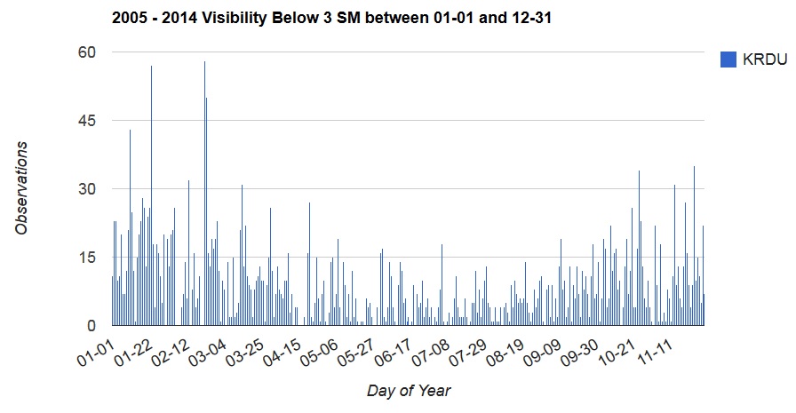
Currently under development is a Fog and Visibility Climatology tool (shown to the left) which collects data from all the active airports in NC and displays the results graphically. By selecting a point on the map, you will be able to view observational history for that location between the years of 2005 and 2013.
With this tool, you will be able to see historical counts of fog occurrences, ceiling heights at 10,000 feet, visibility less than 1 SM and visibility less than 3 SM. For example, during this nine year period at the Raleigh-Durham Airport, there are many reports of low visibility late in the months of January and February. If you plan a flight during this time, it may be smart to prepare for delays!