A Fall-Like Feeling Arrived With Mixed Rainfall in August
Cooler weather made for an unseasonable August, while we started wet and finished the month on a dry note. In this post, we also wrap up the summer and look at the big weather stories awaiting this fall.
An Early Chill Interrupts Summer
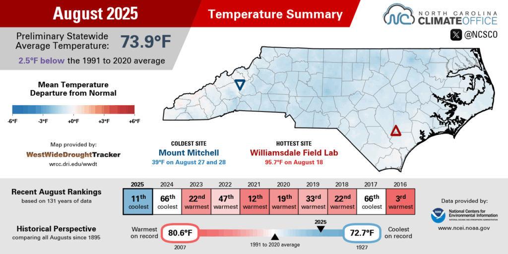
In a sudden shift after a hot end to July, August brought decidedly cooler conditions across North Carolina. Preliminary data from the National Centers for Environmental Information (NCEI) shows an average temperature of 73.9°F, or our 11th-coolest August dating back to 1895, and our coolest August statewide since 2004.
In the cloudiest and rainiest parts of the southwestern Piedmont, it was a record cool month. Statesville tied for its coolest August in the past 118 years, and it was the outright coolest August for both Concord and Tryon.
Elsewhere, it was tied for the 5th-coolest August in Mount Airy, tied for the 3rd-coolest in Elizabeth City, and the 3rd-coolest August on record in Morganton. Greensboro finished with its 8th-coolest August on record, while Raleigh had its 9th-coolest August locally dating back 139 years.
That cooler weather started on the first day of the month, when a cold frontal passage ushered in a Canadian high pressure system from the north. Another strong high to our north brought a reinforcing shot of cool air by August 6.
On that afternoon, temperatures topped out in the low 60s in many areas – more than 20 degrees below normal, and more typical of early November than early August. In fact, on August 5 to 7, Greensboro set or tied its daily record low maximum temperatures.
After that unseasonably cool start, summer-like warmth returned by the middle of the month, with a weekend of upper 80s and low 90s. On August 17, Raleigh hit 92°F in its only 90-degree day of the month. Only four other Augusts in Raleigh have had either zero or one 90-degree days, and this was the first such occurrence since 1971.
That round of heat was short-lived, as another cooler air mass built in by August 19, pushing our highs back into the upper 70s and low 80s. The final two weeks of the month brought only one more sniff of summer on August 25, with upper 80s and low 90s across eastern North Carolina.
Along with a lack of hot days, we had a number of cool, crisp nights with temperatures dipping down into the 50s. Raleigh recorded six such nights with temperatures below 60°F, which was its most in any August since 1997. And on August 27, Mount Airy had a low of 49°F, which was its earliest 40-degree night in a season since August 12, 2008.
Wet Early, then Dry Late
Our wet summer pattern gave way to a drier stretch during July, while the state was also divided between above- and below-normal precipitation. That made for an average August overall, with a preliminary statewide average precipitation of 5.48 inches according to NCEI, and our 53rd-wettest August out of the past 131 years.
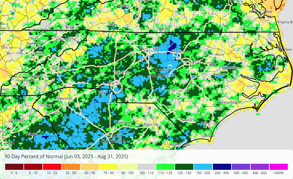
The wettest period was from August 5 to 7, with showers stretching across the Piedmont from Metrolina through the Triangle and three-day totals of more than three inches. With 2.5 inches on August 5, Charlotte had its wettest day since last September during Hurricane Helene.
More rain fell across the southern Foothills on August 12, including 4.75 inches in Forest City – part of a monthly total of 13.12 inches there. Our nearby ECONet station in Spindale had 11.63 inches all month in its 2nd-wettest August since 2014.
In that region, Charlotte had its 22nd-wettest August on record with 7.57 inches, Lincolnton had 7.38 inches in its 9th-wettest August, and Shelby had 8.41 inches to complete its 8th-wettest August.
As the month went along, rain became harder to come by. Parts of the southern Mountains had up to 2 inches of rain on August 19, and the western Piedmont had a final round of locally heavy rainfall on August 22, including up to 3.71 inches in King.
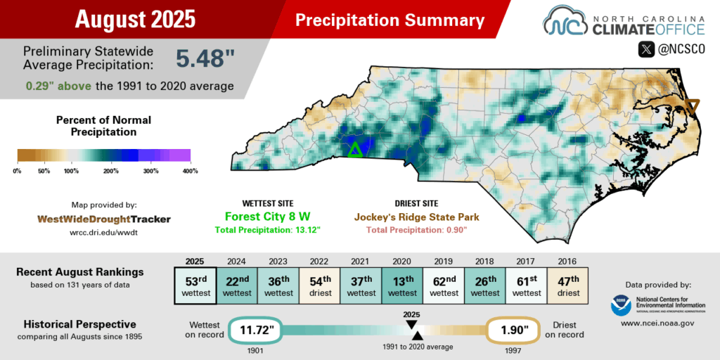
Eastern areas regularly missed out on the rainfall, even when Hurricane Erin passed off our coastline with winds and waves but little rain. Especially in the northern Coastal Plain, it ended as a drier than normal month.
Elizabeth City and Roanoke Rapids each had their 17th-driest August on record, and our ECONet site at Jockey’s Ridge State Park had only 0.90 inches in the 2nd-driest month since that station was installed in May 2022.
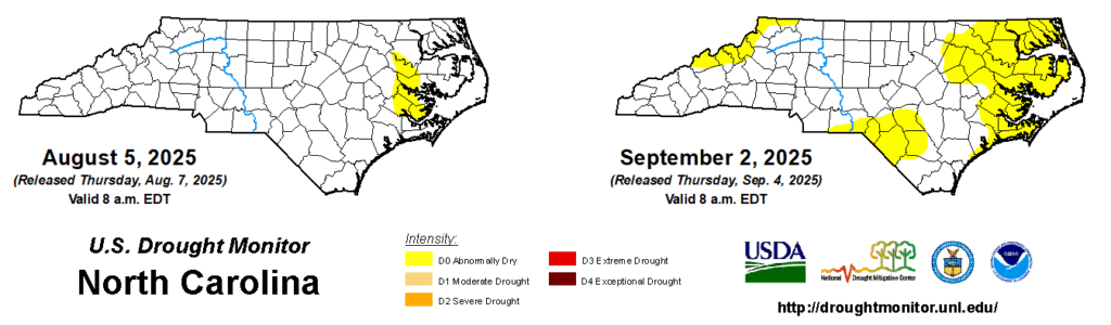
Other parts of the state finished August on a dry note, too. Greensboro and Reidsville both had 17 consecutive rain-free days to end the month, and streamflows in those areas have dropped below normal over the past week. We’ve also seen the sandy soils of the Coastal Plain dry out due to that recent lack of rainfall.
Those short-term deficits and impacts caused Abnormally Dry (D0) conditions to emerge in parts of the state this week. For now, farmers aren’t too distressed by these dry days, since that’s given them a chance to harvest their corn. However, a few Extension agents in eastern North Carolina have reported leaf wilt in soybeans and cotton, plus leaves rolling in the remaining corn crop.
Goodbye Summer, Hello Fall
Even if August’s weather got a bit ahead of itself, the climatological season change officially happened at the end of the month. The preliminary data from NCEI shows that this summer was the 12th-warmest and 53rd-wettest summer on record in North Carolina.
If that high-ranking temperature comes as a surprise, remember that we started the summer with our 13th-warmest June and our 2nd-warmest July. Those first two months of the season featured hundred-degree heat at times, a number of record warm overnight temperatures, as well as high humidity and heat stress at all hours of the day.
August did temper those temperature rankings a bit, though. After July, it was on pace to be the warmest summer on record in Raleigh and the 2nd-warmest in both Asheville and Charlotte. The season finished as the 6th-warmest for Raleigh, tied for the 7th-warmest in Asheville, and the 9th-warmest summer on record for Charlotte.
Our front-loaded rainfall in June and July made for a wetter than normal summer in most areas. In the west, it was the 15th-wettest summer on record in Asheville and the 25th-wettest in Hickory. Among coastal sites, it was the 13th-wettest summer in Greenville and the 27th-wettest in New Bern.
The Piedmont was home to the 27th-wettest summer for Raleigh and the 33rd-wettest in Greensboro, while areas in between that were soaked by Tropical Storm Chantal had a much wetter season. Chapel Hill had 26.40 inches, making it the wettest summer on record there, and Burlington’s 24.72 inches made for its 2nd-wettest summer in the past 23 years, behind only 2003.
Looking ahead to the climatological fall, here are three storylines to watch with our upcoming weather:
False Fall, or Autumn Actually?
Our cool weather in August may have seemed too good to be true, and indeed, it’s unlikely to stay this cool for all of September. Our average last 90-degree day falls on September 12 in Raleigh and Charlotte, and on September 15 in Wilmington, so we’re not out of the woods for summer-like heat just yet.
Sure enough, the upcoming forecast calls for a warm-up this weekend, with high temperatures back in the low to mid 90s on Saturday. But that should be followed by another round of cooler weather next week. Mid-September will be the time to watch, either for summer’s last stand or fall-like weather for good.
More from the Tropics?
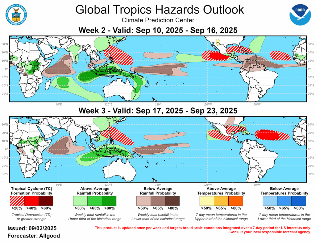
September is typically the peak of hurricane season, and it’s still expected to be an overall active one in the Atlantic, buoyed by the early spate of storms including Chantal and Erin. While it’s tough to tell exactly when and where storms may form, the current Global Tropical Hazards Outlook (below) highlights the Atlantic’s main development region, the Gulf of Mexico, and the warm water around the Bahamas as potential hot spots in the coming weeks.
Recall that Potential Tropical Cyclone Eight set up off our coastline in the middle of September last year, and Helene moved in from the Gulf in late September. In other recent years, we’ve seen October activity such as Hurricane Matthew in 2016 and even some November storms like Nicole in 2022. That means there’s still plenty of time for impactful storms to form this year.
Another Fall Drought Ahead?
Lately, our fall weather has been a story of extremes: either sopping wet from tropical systems, or bone dry without them. Sometimes, we’ve even seen both extremes in the same year, as in 2024, when the storm-soaked September was followed by a parched October. Dry months like that have made drought a mainstay at this time of year, with each of the past four falls having Severe Drought present in parts of North Carolina.
Given that recent history, plus our late-August stretch of dry weather and the potential for a short-lived La Niña pattern emerging later this year, it’s tempting to expect the return of drought at some point this fall. While that could happen, it’s not a guarantee, as the Climate Prediction Center’s latest fall outlook shows equal chances – or no strong guidance – for wet or dry conditions in North Carolina.
Their discussion reiterates the potential for tropical activity coming our way. That means the next few months could be a tug of war between more soaking storms and more dry days. That might make this a familiar fall with extremes in either direction.
- Categories:


