It was a dry month for North Carolina in May, but also a cooler one with a unique high pressure pattern. The ongoing dry weather this spring has seen drought emerge and expand.
Dry Weather Dominates
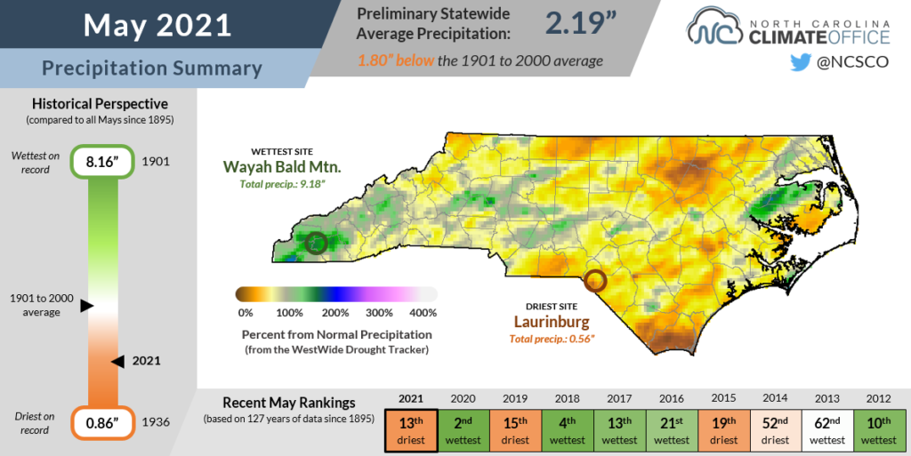
Limited rainfall last month yielded one of the driest Mays in recent memory. According to the National Centers for Environmental Information, it was our 13th-driest May since 1895 with a preliminary statewide average precipitation of 2.19 inches — only about 55% of the long-term average.
The last May that dry in North Carolina was in 2007 as a historic drought developed that spring. Prior to that, May in both 1997 and 1987 were marginally drier than this one, meaning we only see a May this dry roughly every ten years.
Last month started the same way April finished — with several cold frontal passages that soaked the slopes of the southern Mountains but brought only light rain east of the Appalachians.
By mid-month, high pressure sitting over the Carolinas made rainfall increasingly rare. Even afternoon showers were suppressed in this pattern, and sites like Wilmington went 11 straight days without measurable rainfall.
Memorial Day weekend finally brought a respite from the dry weather as a cold front crossed the state, but even that rain was hit-or-miss. While parts of Washington and Beaufort counties picked up almost three inches over a three-day period, the southern coast had less than a quarter-inch, and the southern Piedmont received no rain at all.
The month finished with just 0.95 inches of rain in Wilmington, which tied for its 7th-driest May on record. Only one other May in the past 30 years has had less than an inch of rain there, and that happened in 2019, which also saw drought emerge at the coast.
New Bern only received 1.31 inches for the month, which was its 4th-driest May since 1948. The northern Piedmont also endured a particularly dry month, including the 3rd-driest in Danbury since 1946, with just 1.56 inches there.
Despite starting the month with a few wet weeks, the Mountains also entered a dry pattern by the end of May. For the month, Asheville was 0.76 inches below its normal May precipitation, and Brevard was 1.68 inches below normal.
Cooler May Temperatures
The dry weather was accompanied by surprisingly seasonable temperatures. NCEI notes a preliminary statewide average temperature of 65.9°F, or our 56th-coolest May out of the past 127 years.
Those early-month cold fronts helped keep our temperatures in check, and they even made for a few downright chilly spring nights as lows hit the upper 30s in the Mountains and parts of the Piedmont.
The eventual arrival of high pressure also didn’t take its usual form that can make for some hot, muggy days. By late spring and early summer, we often see the Bermuda high pressure system set up to our east, which brings in warm and humid air from the south.
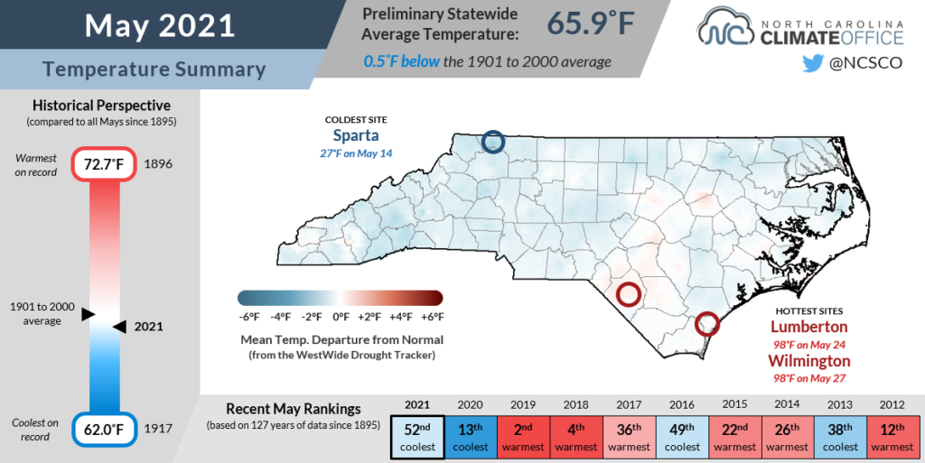
This May, though, high pressure most commonly sat over the mid-Atlantic, which put us under a cooler (but dry) airmass. Our average high temperatures were generally near-normal, with the warmest spots along the sun-soaked coastline. Based on their maximum temperatures, Wilmington and Hatteras recorded their 16th-warmest and 23rd-warmest Mays, respectively.
Lower dew points also made for cooler nights. Based on the average minimum temperatures, Fayetteville tied for its 9th-coolest May in 117 years. In Raleigh, it was the coolest May based on nighttime lows since 2006, and tied for the 27th-coolest all-time dating back to 1887.
Our cooler temperatures certainly helped limit evaporation and heat stress on plants, animals, and people alike, but they couldn’t single-handedly prevent the emergence of drought.
Drought Develops in a Dry Spring
If you missed the official announcement a few weeks ago, then you’ve almost certainly seen evidence of it in your lawn, garden, or rain gauge: drought is back in North Carolina.
Despite our cooler May weather, an overall warm and dry spring has driven drought’s return and initial impacts. Preliminary statistics from NCEI suggest it was our 30th-warmest and 9th-driest spring on record statewide, and like May, it was the driest since 2007.
After our comprehensive Q&A-style drought overview was posted in mid-May, we’ve seen the continued expansion and intensification of drought across the state. Currently, 54% of North Carolina is categorized in drought, including parts of the northern Piedmont that finished last month with little precipitation.
Raleigh experienced its driest spring on record, receiving only 5.02 inches compared to a seasonal normal of 11.01 inches. Moderate Drought (D1) has expanded there on this week’s US Drought Monitor map.
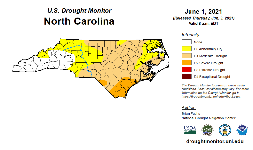
Severe Drought (D2) has now emerged in parts of the southern Coastal Plain for the first time since February 2012. Recent rains have been sparse in that region, and the spring was an arid one for the ages. Both Wilmington and Lumberton recorded their 2nd-driest spring on record with less than half of their normal rainfall.
Farmers across eastern North Carolina are reporting fields too dry to plant and crop growth slowing or stopping altogether. Streamflows are now below normal from the Triangle south and eastward, and groundwater levels in eastern North Carolina have been on a steady decline since mid-March.
In recent weeks, we’ve also seen the first water restrictions implemented. Brunswick County and the Cape Fear Public Utility Authority have requested voluntary conservation, primarily targeting non-essential irrigation, while the town of Carthage in drought-affected Moore County has requested a 5 percent reduction in water use.
These may be the drought’s first fallout for faucets in parts of the state, but they likely won’t be the last. During our last drought in 2019, even a wet June didn’t fully erode the stubborn dryness at the southern coast. In a bit of drought déjà vu, that same region is again in need of rain entering this summer.