On this day in 2018, Hurricane Florence made landfall in North Carolina, and the worst was yet to come as the storm began its crawl across the state. After five days of rainfall, we were left with record flooding and more questions than answers about what the weeks, months, and years ahead would look like.
Our first attempt to put Florence into a broader climate context was our Rapid Reaction blog post from September 18, 2018. It has become one of our most-viewed posts and one of our main resources about the storm and its damage.
With the benefit of time, we now have more perspective about Florence, its impacts, and where it fits within our recent and overall climate. So on the two-year anniversary of Florence hitting North Carolina, we’re taking a look at our initial recap of the storm with added commentary and updated statistics.
Storm History
Considering how 2020 has shaped up, with 19 named storms so far and multiple systems across the Atlantic right now, 2018 appeared quiet by comparison. Florence was only the sixth named storm at that point in the season.
Indeed, it was a relatively inactive season up to that point, but Florence was the start of an uptick of activity near the typical peak of the season. As our original blog post noted:
Cool water across the eastern Atlantic and strong wind shear over the Caribbean Sea inhibited storm development from June through August.
The onset of the climatologically most active month in the tropics brought increasing and above-normal sea surface temperatures off the US east coast, and a surge of five storms developing in a two-week period. Florence was the first of those, becoming a tropical depression just after it emerged off the African coast on August 31.
When all was said and done, 2018 was a slightly above-normal season, with 15 named storms compared to the 1981 to 2010 average of 12.1 storms per year.
And Florence wasn’t the only storm to affect North Carolina that season. Just one month after, the remnants of Hurricane Michael crossed the Piedmont at tropical storm strength, whipping up winds to levels not seen since Hurricane Hugo in 1989.
While we compared Florence’s track and meteorological evolution to Hurricane Isabel, which also weakened as it approached the coast, time has made it clear that their impacts were vastly different.
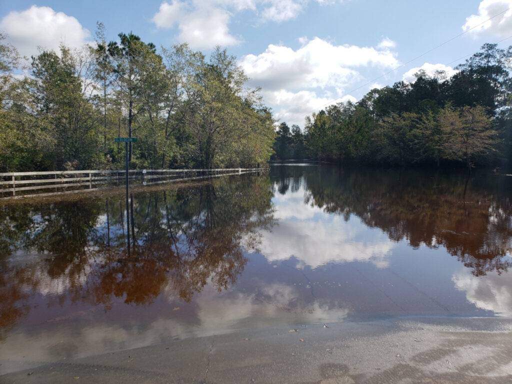
Two months after Isabel, even the segment of Hatteras Island that was washed out by the storm had been rebuilt. Two months after Florence, coastal communities such as Pollocksville in Jones County were still drying out, with homes and businesses damaged by mold or destroyed by the 20-foot high flood waters.
As time has gone on, it has become increasingly clear that Florence almost defies comparison, as there were few short-term solutions or easy rebuilds in the wake of the flooding that it left behind.
High Winds and Storm Surge
Florence’s weakening to a Category-1 storm at landfall was a relief to many, but it was still a potent hurricane even hours after moving over land. The National Weather Service in Wilmington compiled impacts across the southern coast and noted hurricane-force wind gusts throughout Pender County, which suffered significant damage due to downed trees and eroded sand dunes.
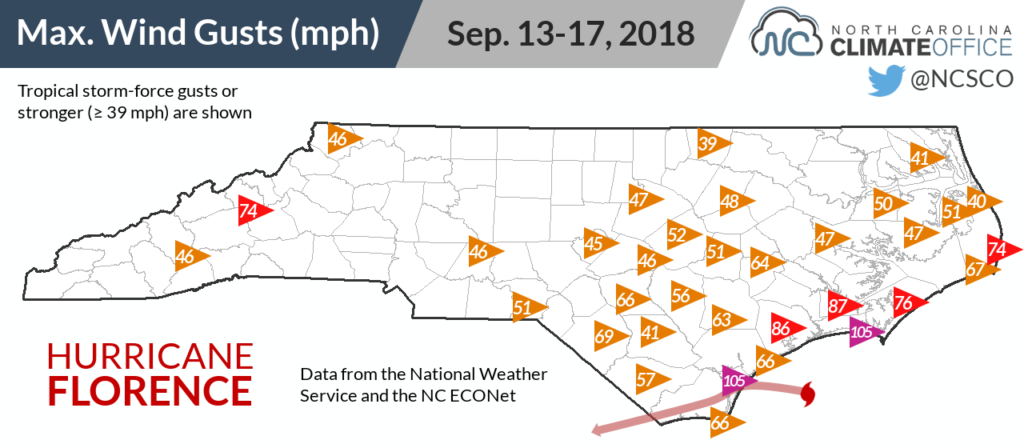
As Florence crept inland, so did its gusty winds, and our office’s weather station network made an impressive measurement of the storm’s broader impact across the state, which we shared in our original post:
The storm’s large diameter meant tropical storm-force winds were felt nearly 150 miles from the center, as far north as Warrenton. Among our ECONet, 21 stations — exactly half of our network — experienced wind gusts of 40 mph or greater.
Operating a statewide network like the ECONet isn’t easy, especially during a hurricane, but preparations and contingencies we set up long before Florence helped keep our network running during that event, as our ECONet manager Sean Heuser explains:
One of the biggest assets of the ECONet is that the majority of the stations run off of solar power and have a battery that can withstand a few days with little to no sunlight. This was critical during the storm as only one of our 42 stations lost power during the event. Furthermore, since the majority of our stations communicate via cell phone, as long as the cellular networks were up and running, we were able to collect the data at our usual five-minute interval.
Quality-controlling the extreme rainfall totals measured during the storm also made for quite the challenge. However, because we test all of our rain gauges every summer and replace the ones that fall out of calibration, we had confidence that their precipitation totals were accurate.
We did have one issue with our Castle Hayne station not reporting any precipitation during the storm. This is where having a second precipitation sensor at each site comes in handy. We used the impact sensor’s precipitation totals during the storm — 19.23 inches from Florence — and for weeks afterwards, since the massive flooding around Wilmington delayed our return visit to repair the tipping bucket sensor.
Maintaining a statewide weather network provides a number of unique challenges. However, visiting sites three times per year for routine maintenance ensures that the stations are always in good condition and gives us confidence that they will perform as intended during historical storms such as Florence.
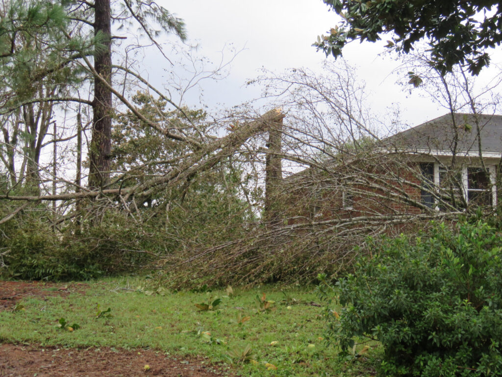
Those widespread high winds combined with soils weakened by the rain resulted in many downed trees and power lines. Duke Energy alone reported 1.8 million outages across the Carolinas. The NWS Wilmington said that more than 90% of New Hanover County lost power during the storm, and portions of Whiteville in Columbus County were without power after an electrical substation flooded.
Rainfall and Flooding
Some of the most impressive observations made during the storm were the extreme rainfall totals — the result of an estimated 8 trillion gallons of water falling across the state over a five-day period. Our original blog post explained the unusual circumstances that led to such heavy rain:
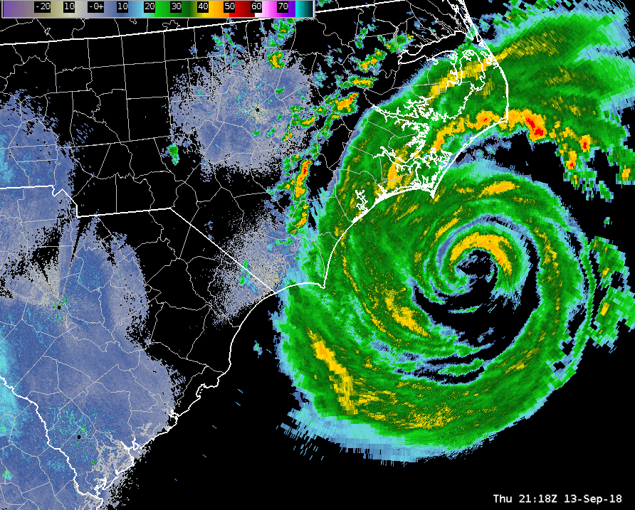
As a stark contrast to many of our other hurricanes that quickly move through the state after making landfall, Florence slowed down to a crawl. Upper-level high pressure systems surrounded the storm on three sides, and with nothing in the atmosphere to steer the storm, it moved westward at a mere walking pace over the weekend.
That made rainfall and inland flooding the greatest threat from Florence, especially across the southern coast. A moisture-rich onshore flow allowed for several days of heavy rainfall that shattered the state record for rainfall from a tropical system of 24.06 inches, which was set over a four-day period in Southport during Hurricane Floyd in 1999.
After the rainfall reports from Florence rolled in, the highest amount in the state was 35.93 inches — nearly three feet of rain! — as measured by a CoCoRaHS observer near Elizabethtown in Bladen County.
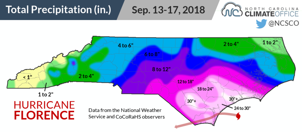
This dense network of volunteer precipitation reporters proved its worth during Florence. In 58 counties, the highest storm-total rainfall was measured by a CoCoRaHS observer.
An analysis conducted by our office last year also found that the average precipitation from CoCoRaHS observations in the Coastal Plain was an inch greater than from other monitoring networks — a testament to the ability of the volunteer network to track localized conditions where automated weather stations often aren’t available.
Our post from September 2018 also pointed out that the rains from Florence added to the wet start of the year in many locations:
Prior to the storm, Hatteras and Wilmington were already on pace for their wettest years on record, as well as Marion and Mount Mitchell in the western part of the state. The 23.05 inches of rain from Florence at the Wilmington Airport bumped up its year-to-date total precipitation to 86.25 inches. That site has already set a new record for annual accumulation, besting the 83.65 inches in 1877, and there are still more than three months left in the year!
By the end of the year, Wilmington finished with 102.40 inches of total precipitation, and Mount Mitchell set a state record for the wettest calendar year at any single location, with 139.94 inches total.
It was also North Carolina’s wettest year on record dating back to 1895, with a statewide average precipitation of 68.35 inches. That broke the previous record of 63.16 inches from 2003 by quite a wide margin, and the rain from Florence — including more than a foot across the Sandhills and southern Coastal Plain — was a key contributor to that number.
A Storm for the Records
Two years after Florence, we have a better feel for the damage from the storm, and it was immense. Florence sits at the top of the list of our costliest hurricanes. The governor’s office estimates statewide damages from Florence totaling $17 billion. This is more than the combined damage from Floyd and Matthew, which are the most similar storms in the historical record that also caused widespread inland flooding.
Florence was also responsible for 45 confirmed fatalities in North Carolina. That places it in fourth among our state’s deadliest known hurricanes, behind the July 1916 storm (~80 deaths), the September 1883 hurricane (53 deaths), and Floyd (52 deaths).
Since Florence, we’ve been asked how rare of an event it was, and whether it could happen again. Quantifying a storm like it is challenging since there are so few historical data points on that end of the distribution, but based on streamflow observations from across the Carolinas, the US Geological Survey attempted to assign some measure of Florence’s extremity:
Twenty-eight of the 80 streamgages measuring streamflow had new peaks of record. … Of the 28 streamgages analyzed, the estimated annual exceedance probability (AEP) for the Hurricane Florence peak streamflow at nine of the streamgages was less than 0.2 percent, which in terms of recurrence intervals is greater than a 500-year flood event, at three streamgages it was equal to a 0.2-percent flood event (500-year recurrence interval), and at six streamgages it was between a 0.2- and 1-percent AEP flood (between a 500- and 100-year recurrence interval, respectively). For the remaining 10 streamgages, the estimated AEP was between 1.5 and 7.1 percent, which in terms of recurrence intervals is approximately a 67- to 14-year flood event, respectively.
Hurricane Floyd was also believed to be akin to a once-in-a-lifetime event, but we’ve now had three major flood-producing hurricanes in the past two decades. Changes in the background climate seem to be stacking the odds in favor of storms like these.
Warming in the atmosphere and oceans is increasing the water vapor content and supercharging tropical storms with moisture. Released this spring, North Carolina’s first Climate Science Report — a summary of the best available science on climate change and its impacts in our state — found that “Heavy precipitation accompanying hurricanes is very likely (90 to 100% probability) to increase, increasing freshwater flood potential.”
That report also noted that “While global warming is likely to lead to heavier rainfall rates in hurricanes, there is no scientific evidence that future landfalling hurricanes are more likely to slow down after landfall.”
So heavier rain and frequent flooding from tropical storms may continue to become more common, but the meteorological factors surrounding Florence that caused it to slow down so substantially should remain a rare and exceptional event.
Two years after Florence, recovery is still underway, while rebuilding and planning for the next storm also remains a constant concern, especially amid the recent activity in the Atlantic. We’ve now had three landfalling hurricanes (Florence, Dorian, and Isaias) in a two-year period, which has previously happened only three other times in the past 170 years, in 1984-86, 1954-55, and 1878-80.
Add in Matthew, which remained just offshore but still caused record flooding along the Cape Fear and Neuse rivers, and the remnants of Michael, and we’re looking at five impactful storms in a four-year stretch.
Among them, though, none compares to the extent — with rain and gusty winds from the shores to the slopes — and record-breaking extremity of Hurricane Florence, that even two years later leaves us in awe at the memories of interstates-turned-canals, homes swallowed up by the floods, and a storm that sat over us for five days straight.