June continued our late-spring cooler pattern with wet conditions in parts of the state. At the halfway point in 2020, we also check the year-to-date temperature and precipitation rankings.
Cool Temperatures and Cloudy Days
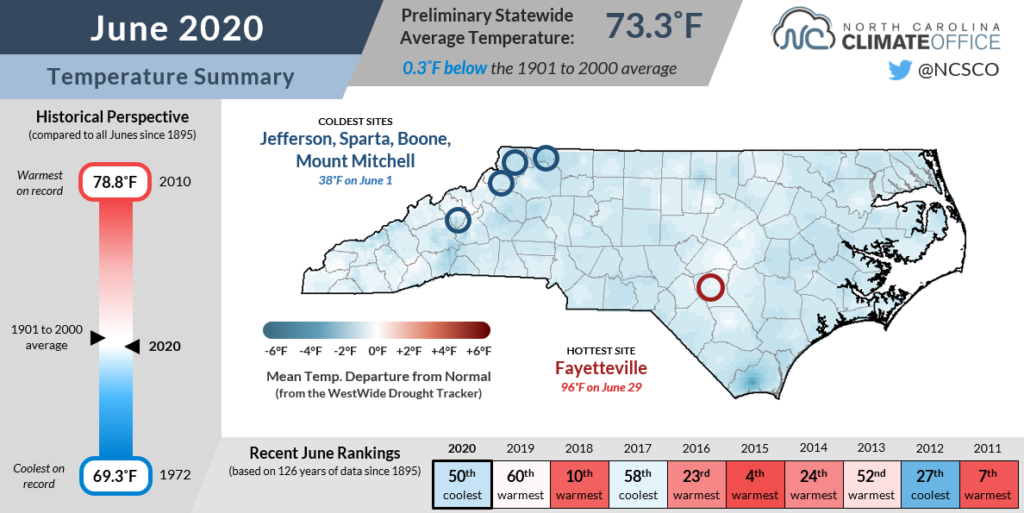
Our cool spring has spilled over into summer. The statewide average temperature last month was 73.3°F, ranking as our 50th-coolest June since 1895, according to data from the National Centers for Environmental Information (NCEI). In the past 20 years, only three Junes in North Carolina have been cooler — in 2012, 2006, and 2003.
The coolest spots compared to normal were in the southern and central Coastal Plain. Sites such as Wilmington, Lumberton, and New Bern had average mean temperatures 2 degrees below normal.
Average maximum temperatures were up to 4 degrees below normal, while average minimum temperatures were generally near-normal to slightly above normal. That more limited daily temperature range, with cooler highs and warmer lows, is often the signature of a cloudy month, and June was no different.
The Wilmington Airport reported 176 hours — or 24% of the month — with mostly cloudy or overcast sky conditions. By that measure, it was the cloudiest June there since 1999, and had twice the number of mostly cloudy hours as June 2019.
Similarly, Greensboro had 232 mostly cloudy or overcast hours and Raleigh had 200 such hours, giving them their cloudiest Junes since 2003 and 2004, respectively.
Contributing to that cloudy weather were several notable events. On June 11-12, a stalled cold front along the coast produced persistent cloud cover and up to 4 inches of rainfall in the Wilmington area.
On June 15-16, high pressure to our north put us in a rare summertime cold air damming pattern. During that two-day period, temperatures hovered in the upper 50s and low 60s, with daytime highs nearly 25 degrees below normal. In Charlotte, the maximum temperature of 61°F on June 16 was the second-coolest June high dating back to 1940. The only colder June day there came on June 1, 1967, with a high of 59°F.
During the second half of the month, temperatures did rise a bit closer to normal, but it was a far cry from the extreme heat we’ve seen in some past Junes. Greensboro made it through the entire month without reaching 90°F, and didn’t hit that mark until July 1. That was the 9th-latest occurrence of their first 90°F day dating back to 1903, and another sign of the unseasonably cool weather we’ve had over the past three months.
Heavy Rains Soak the Coast
The same weather features that produced such cloudy weather also made for a wet month in some areas. NCEI reports the statewide average precipitation in June was 4.83 inches, making it our 50th-wettest June since 1895.
While above-normal rainfall wasn’t widespread across the entire state, sites especially in eastern North Carolina that saw rain were soaked. The wettest spot in the state last month, Wilmington, received 11.11 inches of rain — the 9th-wettest June there since 1874. With 8.66 inches of rain, Lumberton had its 7th-wettest June on record.
Hatteras had 9.01 inches and its 6th-wettest June since 1893, with 8.53 inches of that accumulating during a particularly wet week from June 11 to 17. During that time, an upper-level low pressure system over the Carolinas pumped in abundant moisture off the Atlantic.
Those rains raised the Tar River at Rocky Mount to a crest of 27.24 feet, or 6 feet above flood stage. That was the third-highest crest on record at that site, trailing only the heights following hurricanes Floyd and Matthew.
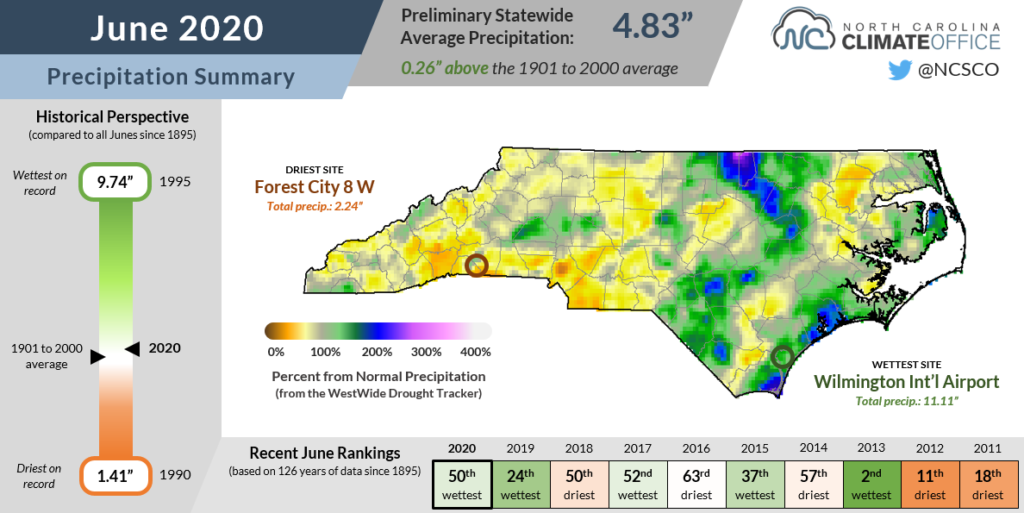
The rest of the state missed the heaviest rain but was still within an inch or two of its normal June precipitation. The driest spots were in the southern Foothills and Mountains, including Asheville, which recorded 2.4 inches of rain for the month, or 2.2 inches below normal.
That region has seen soil moisture levels drop slightly below average, but the cooler temperatures and generally wet weather in recent months have kept drought from becoming a concern as we head through the summer.
Monthly average streamflows remain near- to above-normal statewide, and most crop reports indicate that recent rainfall has delayed planting due to wet fields, while some crops already in the ground such as corn and wheat have deteriorated due to nutrient loss, pests, and disease pressures due to the excess moisture.
While that surplus could quickly disappear with a stretch of dry days during our typical hottest time of the year in mid-July, for now, conditions remain more wet than dry.
A Mid-Year Update
Coming off North Carolina’s warmest year on record, a common question has been whether 2020 would keep up with, or even exceed, the scorching pace set in 2019.
Early in the year, it did. January through April ranked as the 4th-warmest on record, and was 1.7°F warmer than the first four months of 2019.
But a switch from our warm wintertime pattern, with high pressure over the Southeast, to a cooler spring and early summer pattern with more jet stream troughing over the eastern US, has also dropped 2020 a few spots down the rankings at the midpoint of the calendar year.
The average temperature from January through June of 57.27°F — or 2.42°F above the 1901-2000 normal — ranks as the 9th-warmest start to a year since 1895. So far, 2020 is 0.41°F behind the 2019 pace, and 1.31°F behind the average from 2017, which holds the record for the warmest first six months of a year in North Carolina.
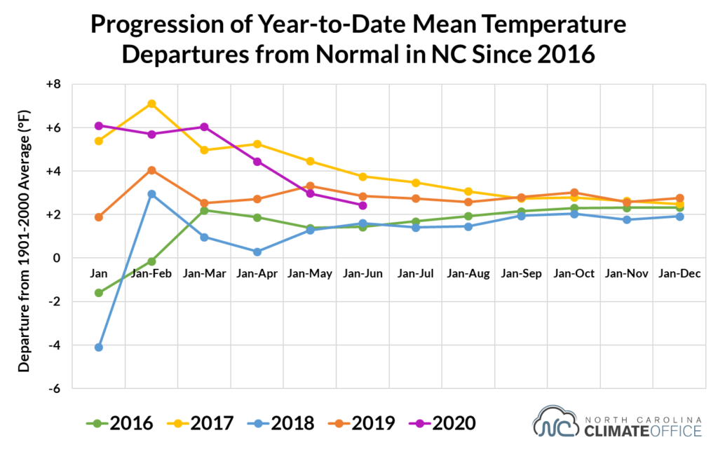
Although daytime high temperatures haven’t been particularly hot this spring and summer, our overall temperature ranking remains relatively high due to the warm overnight lows. Our average minimum temperatures this year rank as the 2nd-warmest on record, just ahead of the 2019 average lows to this point.
So in six months’ time, could we be talking about 2020 as the state’s new warmest year on record?
It’s certainly possible, but after a few cool months recently, that has become less likely. Considering that some of the warmest months last year came in the late summer and early fall, it might take an even more sweltering September or oppressive October for this year to contend for the record.
In terms of precipitation, it’s probably no surprise that 2020 has been among the state’s wettest to this point given the drenching rains we’ve seen. With a statewide average of 32.11 inches of precipitation for the year to date, 2020 ranks as the 4th-wettest year on record through the end of June.
Of course, tropical activity tends to be a key contributor to our precipitation later in the year. That was certainly the case with our wettest year in 2018, which ranked as the 25th-wettest at the end of June but rose quickly up the rankings after Hurricane Florence.
The bottom line is that six more months could shift our patterns and perceptions of 2020’s weather, but so far, the year has fit with recent trends. Based on the January through June rankings, each of the past six years has been warmer than normal, and each of the past four has been wetter than normal.
Old habits may be hard to break, but when it comes to our climate, the new ones appear to be just as stubborn.