Plenty of April showers made for a wet month in North Carolina, and our weather pattern was also a cooler one with some gusty winds for good measure.
Wet and Severe Weather
Rain was widespread last month, giving an overall wet April across almost the entire state. The National Centers for Environmental Information (NCEI) reports a statewide average precipitation of 5.15 inches, which ranks as our 17th-wettest April since 1895.
The highest totals came in the Mountains from a series of moisture-rich cold fronts that moved in from the west and southwest. The wettest site in the state, Highlands, recorded 12.73 inches for the month, while in the northern Mountains, Boone had its wettest April since 1982 with 11.70 inches.
The western Piedmont also picked up heavy rainfall. In Mount Airy, it was the wettest April out of 120 years of observations with 8.84 inches of precipitation. Charlotte had 7.10 inches and its 6th-wettest April on record, and Gastonia had 6.33 inches for its 5th-wettest April since 1931.
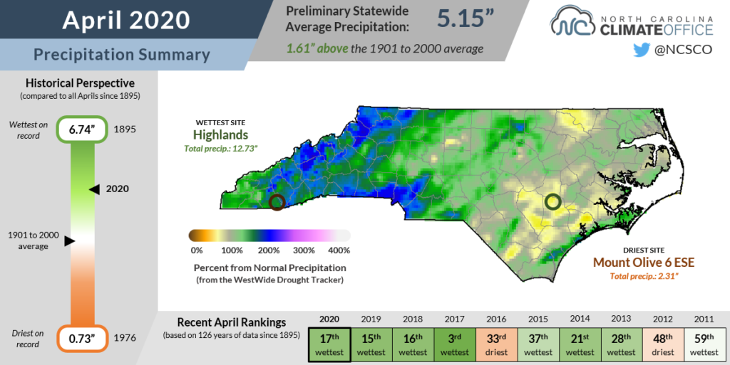
The driest spots were across parts of the Coastal Plain that didn’t see the same coverage of heavy rainfall, but even these sites finished the month close to normal. In New Bern, the monthly precipitation total of 2.84 inches was just 0.3 inches below normal.
The southern coast did see the bulk of the severe weather activity on April 13 during that morning’s tornado outbreak. A total of 16 tornadoes were confirmed across the state that day, including nine EFOs, six EF1s, and one EF2.
While those were the only tornadoes in North Carolina last month, it was still an active month for thunderstorms. The National Weather Service issued a total of 473 severe thunderstorm warnings across the state — the most in a single month since last August. It’s also an impressive total considering there were just five severe thunderstorm warnings in the state in March!
Temperatures Take a Plunge
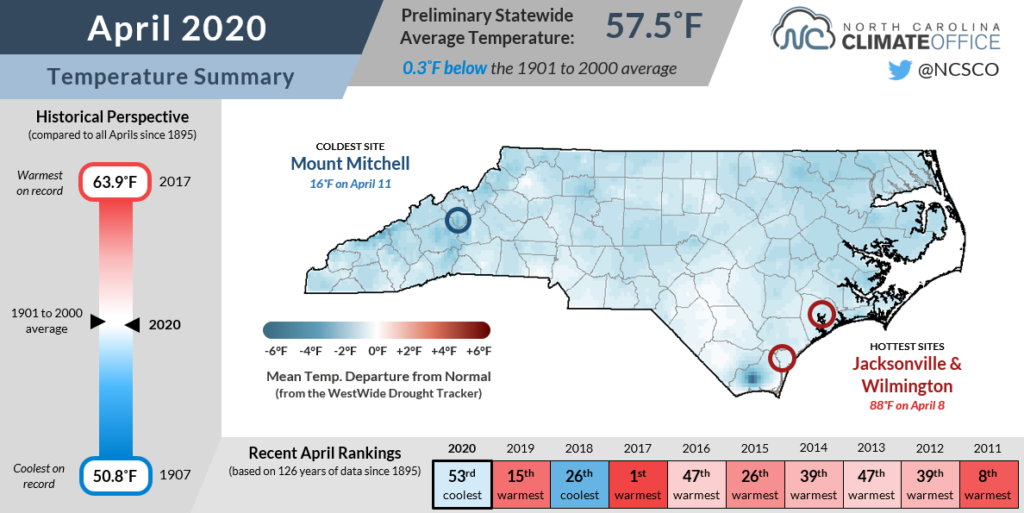
March may have ended with temperatures approaching 90 degrees in parts of the state, but that sort of extreme heat was nowhere to be found in April. NCEI notes the statewide average temperature last month was 57.5°F, which was our 53rd-coolest April out of the past 126 years.
Most sites finished the month with average mean temperatures within a degree or two of normal. The coolest sites were in the rain-soaked parts of the Mountains, including Jefferson, which tied for its 4th-coolest April out of 88 years with data.
Along with cloudy, wet weather keeping temperatures down, pronounced troughing in the jet stream over the eastern US persisted throughout the month, which contributed to our overall unsettled April pattern.
It was indeed a big change from the ridging over the southeast US that we saw throughout March. With temperatures well above normal, it was tempting to think we’d seen the last of winter.
But Mother Nature had a mid-April surprise in store, with shots of cool air on the morning of April 11 — and again on April 16 — that dropped temperatures below freezing across most of western and northern North Carolina.
While that timing was near or only slightly later than the typical last spring freeze dates in those areas, it still came as a shock to the system, and certainly to a few plants, after the early onset of the growing season and more than a month without sub-freezing temperatures.
Low Pressure, High Winds?
If you woke up to winds whipping up outside, pelting rain on your windows, or littering your yard with fallen trees and branches, you might expect that April was a windy month in North Carolina.
But based on the average wind speeds, it doesn’t exactly stand out. At the Raleigh-Durham Airport, last month ranks as the 13th-least windy April out of the past 72 years!
So what gives? Did our brains also go into quarantine last month and just imagine the windy weather?
To answer that, let’s think about how wind is generated. Scientifically, it’s due to strength of the pressure gradient force, or the difference in pressure across a given distance.
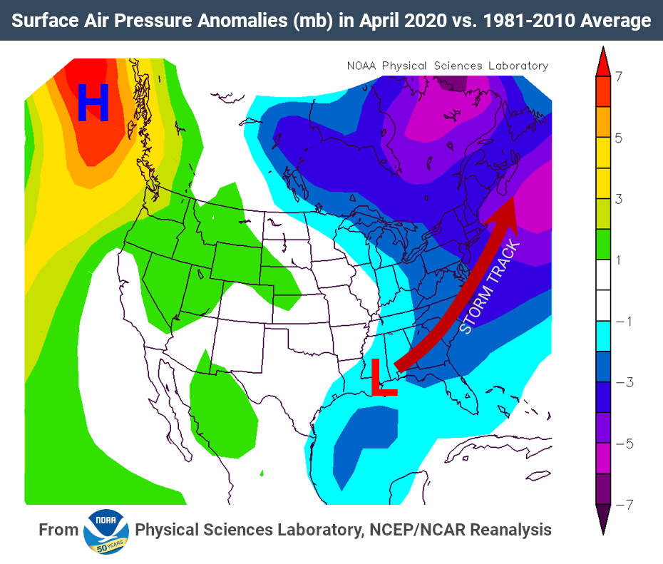
When you’re between strong high and low pressure systems — like we often see on those sunny days just before or after a hurricane hits the state — you typically have high sustained winds due to the intense pressure gradient.
When we look at the average air pressure last month, we see that it was quite low across the US east coast. In Raleigh, Wilmington, Asheville, and Greensboro, the average sea level pressure ranked as the fourth-lowest on record for the month of April, while it was the third-lowest in Charlotte and Hatteras.
However, the standard deviation of our hourly air pressure was also low — including the sixth-lowest on record in Asheville — indicating an overall lack of variance throughout the month.
That tells us it was a stormy month characterized by frequent low pressure systems, but without many strong high pressure systems pushing eastward to ramp up the pressure gradient, we also didn’t have consistently high winds.
As your memory — and perhaps your mulch bed littered with sticks and leaves — reminds you, though, we did have some strong winds during those passing storm systems. Raleigh reported 120 hours with gusts above 20 mph, and Wilmington had 155 hours with gusts that strong.
We see those trends all across the state, from our high-elevation mountain sites — Mount Mitchell had 144 hours, or the equivalent of six full days, with gusts exceeding 30 mph! — to the Outer Banks, where Hatteras reported a gust as high as 53 mph on April 13 — the strongest April gust there dating back to 2005.
So while the wind wasn’t howling all month, when it did, it was noticeable. Those gusty winds were just one side effect of a month with ample April showers and some storms to boot.