Last week included a decidedly bad Friday weather-wise for much of North Carolina as severe thunderstorms produced damaging straight-line winds and tornadoes across the state.
The event was well-forecasted several days in advance since it appeared likely that the same system bringing severe storms to the Midwest and Deep South on Wednesday and Thursday would move through a similarly favorable environment over the Carolinas on Friday.
The setup featured the same components for a tornado outbreak that we saw during the record-setting April 16, 2011, event:
- A feed of moist air from the Gulf of Mexico provided fuel for developing clouds and thunderstorms.
- A cold front arriving late on Friday provided the lift needed to kick off thunderstorms, and its timing coincided with the peak of daytime heating and increasing atmospheric instability.
- The cold front itself was strengthened by both an impressive pressure gradient and temperature gradient around it. High temperatures surged into the upper 70s on Friday afternoon ahead of the front, while overnight lows dropped below freezing in the Mountains on Saturday morning, allowing lingering precipitation to fall as snow at some higher elevations.
- While winds at the surface were gusty throughout the day due to the pressure gradient around the front, just a few thousand feet off the ground, they were even stronger. Southerly winds of more than 60 mph ramped up the wind shear and helicity, both of which help generate spiraling air currents near the ground that can then be tilted vertically by an updraft. That rotation can become the basis for a tornado.
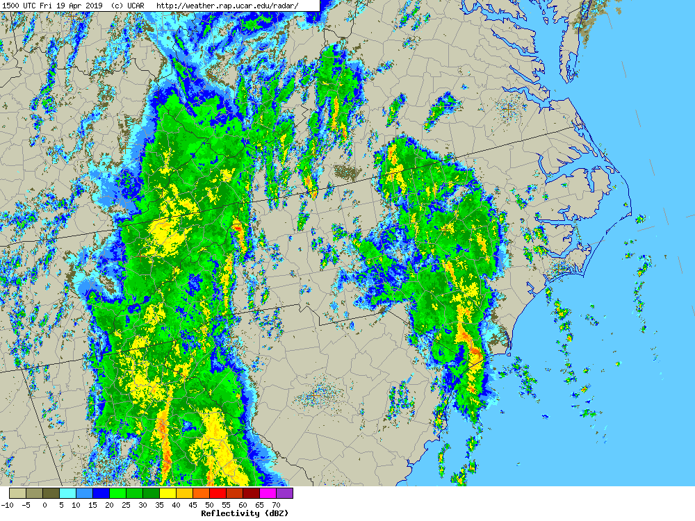
With these ingredients in place, the National Weather Service Storm Prediction Center classified parts of central and eastern North Carolina in a Moderate Risk for severe weather — the fourth-highest out of five risk levels. The last date with such a high risk was February 24, 2016, when an unusually strong line of late-winter thunderstorms spawned six tornadoes in North Carolina.
Tornado Summary
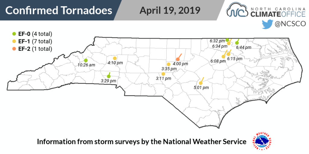
With strong confidence in having potentially dangerous storms on Friday, it seemed like only a matter of when — not if — they might develop. The first tornado of the event in North Carolina touched down around 10:26 am near Ashford in McDowell County. This EF-0 tornado was on the ground for less than a mile along US 221, with some minor tree and building damage observed.
As morning rain showers moved out, a series of individual supercells began forming across the western and central Piedmont by mid-afternoon. Generally moving from south to north, these cells warranted severe thunderstorm and tornado warnings that at times spanned nearly the entire state from south to north.
Two tornadoes touched down in the western Piedmont: an EF-0 in Gaston and Lincoln counties that was responsible for an injury when a tree fell on a house, and an EF-1 north of Hiddenite in Alexander County.
Between 3 and 4 pm, supercells spawned separate EF-1 tornadoes in northern Moore County and near Siler City in Chatham County. The strongest tornado of the day in North Carolina formed in southwestern Orange County and reached EF-2 strength as it neared Hillsborough. Along its path estimated at 12 miles long and a maximum of 600 yards wide, the roof and exterior walls of one home were reported as completely destroyed.
Around 5 pm, a supercell spawned an EF-1 tornado in northern Sampson County that eventually crossed into Johnston County. The National Weather Service survey found that along a roughly 10-mile path, the tornado touched down multiple times, causing some tree and roof damage and scattering debris.
To the west of these discrete supercells, a squall line — a narrow and largely continuous line of storms — formed over the western Piedmont and raced eastward at nearly 40 mph. As this line arrived in the eastern Piedmont it overtook the individual supercells and the line began to bow outward, bringing strong straight-line winds in addition to the lingering tornado threat.
This line spawned a cluster of tornadoes in quick succession in Nash, Edgecombe, Halifax, and Northampton counties between 6 and 7 pm, including two EF-0s and four EF-1s. One tornado beginning in Halifax County crossed the Roanoke River into Northampton County and eventually into Virginia. It was initially counted twice since it was surveyed by both NWS Raleigh and NWS Wakefield, but it has since been consolidated into a single report.
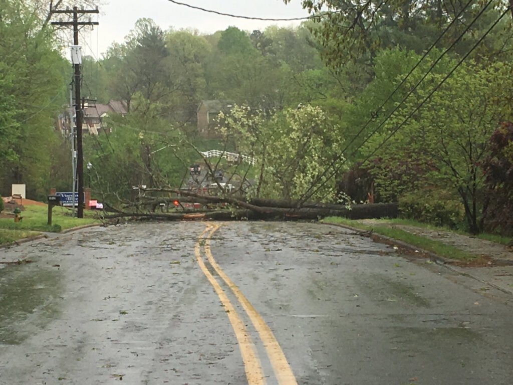
After sunset, the severe weather risk decreased as the line of storms exited the Coastal Plain, but the storms had literally left their marks, with widespread reports of tree and structure damage from the tornadoes.
Wind gusts in excess of 40 mph also caused some damage. Fayetteville reported a maximum gust of 64 mph on Friday, while Rocky Mount had a peak gust of 56 mph. Our ECONet stations at Frying Pan Mountain, Mount Mitchell, Bearwallow Mountain, Hamlet, and Clayton all received gusts of 50 mph or greater.
Throughout the day on Friday, portions of 37 counties in North Carolina were under a tornado warning at some point. While the National Weather Service continues to conduct on-the-ground surveys to verify the damage and intensity from Friday’s storms, as of Wednesday morning, 12 tornadoes have been confirmed in North Carolina from the outbreak.
That ranks tied for the sixth-most tornadoes on a single day in North Carolina based on Storm Prediction Center reports going back to 1950. It’s also the most since 30 touched down in the April 16, 2011, event — still our state’s all-time record for tornado activity.
While it was a busy afternoon for forecasters with a map checkerboarded by warnings and a nervous one for folks in the paths of storms, it could have been worse, both in terms of the storms themselves and their impacts.
The morning cloud cover never fully burned off, which may have prevented the atmosphere from reaching its maximum instability. Even still, the environment was ripe for severe weather; at one point on Friday afternoon, the Significant Tornado Parameter — an index combining instability, wind shear, helicity, and several other key ingredients for EF-2 or stronger tornadoes — had a bullseye of high values across central North Carolina.
Just one injury and no deaths have been reported from any of the afternoon’s storms in North Carolina, which given their widespread coverage was also a relief, especially considering the fatal toll of that same system across the Midwest.
After a largely quiet 2018 for thunderstorm-related tornado activity — 23 of our 33 tornadoes last year came during Hurricane Florence — this event showed that spring is still king for severe weather in our state.