After the emergence of warm, dry weather last month, you might have been more likely to have pollen or dust coating the bottom of your rain gauge than actual precipitation. But even when the gauge is dry and you have nothing but a zero value to report in your daily CoCoRaHS observation, you can still share valuable information about your local conditions as part of the CoCoRaHS Condition Monitoring program.
That program is an effort spearheaded by the Carolinas Integrated Sciences and Assessments team, or CISA, who is working with volunteers throughout the Carolinas to improve our understanding of how drought impacts ecosystems and communities.
Along with submitting daily rain, hail, and snow measurements on the CoCoRaHS website, citizen scientists can submit weekly condition monitoring reports, to share information about how recent rainfall, or a lack thereof, has affected the plants, animals, and people in their area.
This project is part of the National Integrated Drought Information System (NIDIS) Coastal Carolinas Drought Early Warning System (DEWS) program. The Coastal Carolinas DEWS is a collaborative effort among federal, state, and local agencies to improve early warning capacity and resilience to drought in the Carolinas, with special focus on the coastal regions of the two states.
Regular reporting helps us to identify expected seasonal changes — for example, soils generally being drier in the summer because of hotter weather, longer days, and more evaporation — versus changes caused by unseasonably wet or dry weather conditions. Reports can also reveal the onset, intensification, or recovery from wetter- or drier-than-normal conditions.
The CoCoRaHS Condition Monitoring project is based on the idea that everyone is an expert when it comes to their own backyard or the places they frequent. I know the areas in my yard that are usually soggy and which ones are usually dry. Likewise, I know when I typically see pollen covering my deck and how often I usually water my established perennial plants in the summer. (Ideally, never!)
The Value of Condition Monitoring Reports
We’re getting pretty good at measuring and estimating precipitation and temperature, even in places where there are no weather stations or other ground-based observations. However, this information can only tell us so much and, especially when it comes to monitoring drought, we are still in need of more on-the-ground information.
A drought is measured by its impacts. If there are no impacts, we can’t really call it drought — just dry weather. We can make inferences based on the data we do have, but this is an area where CoCoRaHS Condition Monitoring volunteers can help fill in the gaps by providing local expertise about on-the-ground conditions that we don’t typically receive from other sources, such as agricultural extension agents.
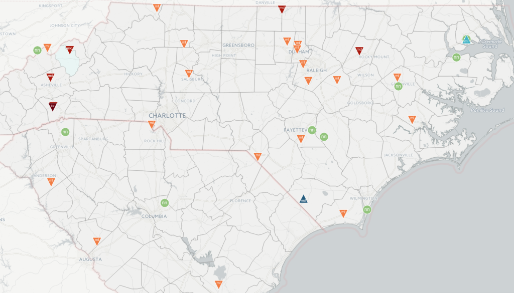
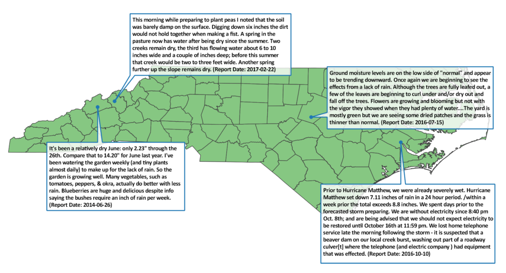
Currently, CoCoRaHS Condition Monitoring reports are being used to help assess drought conditions in North Carolina. As more and more observers contribute regularly, we’ve also noted potential applications with gleaning impacts information during wetter times. One such example is found in the report below discussing Hurricane Matthew’s impact.
Don’t live in North Carolina? No problem! The CoCoRaHS Condition Monitoring form is open to every CoCoRaHS observer across the nation. In fact, since the project expanded from the Carolinas to the national level in October, more than 7,000 reports have been submitted!
Researchers are interested in using on-the-ground conditions reports to help determine just how accurate the drought indices and metrics we use are. By taking observations and recording them, you’re providing detailed, useful information about conditions across the whole spectrum of moisture — from dry to normal to wet.
How Does it Work?
Whenever you find yourself outdoors, spend a few moments observing things that are influenced by moisture. For example, if you planted something, was the soil moist? If it was dry, how dry? Is it drier or wetter than the last time you felt it, and when was that? If you raked leaves, were they wet and soggy or dry and crackling? This is by no means an exhaustive list, but merely a few questions to get you thinking.
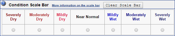
Then, on Saturday or Sunday, go to the CoCoRaHS website and enter a summary of what you observed. This can be as long as you’d like — don’t be afraid to get detailed! When you enter in your report, there will be an option to assign a scale bar quantity to your observations. These range from “Severely Dry” to “Near Normal” to “Severely Wet” and should describe a “general picture” of what you observed over the course of the week. If you’re unsure, you can leave it blank — don’t worry, we’ll still be reading your reports even if you don’t include this part.
Reporting on Saturday or Sunday will allow report users such as US Drought Monitor (USDM) contributors and authors to view updated information before the USDM map is updated each week. While reporting each week is ideal, some observers report once every two weeks or once a month, and this is also fine. The most important thing is to try to report consistently over time.