The first winter storm of the season for most of North Carolina brought widely varied impacts across the state, with more than 10 inches of snow in the Triad, a wintry mix in the Triangle and Charlotte, and a run-of-the-mill rain event along the coast. That was followed by the coldest air of the season as temperatures plunged into the low teens and single digits.
Following a Familiar Pattern
The storm began to take shape in the middle of last week as an upper-level disturbance dug southward from the Rockies toward the Gulf of Mexico. A surface low formed over the Texas coast on Thursday afternoon and eventually moved off the Southeast coast on Saturday morning with the precipitation event already in full swing.
For the most part, it matched the Miller type A pattern that we see from many of our winter storms, with one notable exception. In this case, there was no strong high pressure system to our north that funneled cold air southward. That meant our surface temperatures were in the upper 30s as the event began but cooled as precipitation fell and melted in the dry near-surface air.
Moisture flowing in from the Gulf of Mexico fueled precipitation throughout the event, which began as sleet or rain in most places before switching over to snow in the western half of the state. Across the Coastal Plain, precipitation fell as mostly rain as surface temperatures hovered in the mid to upper 30s.
As is common in these sorts of events, the Piedmont was the precipitation battleground. A narrow zone from Charlotte through Raleigh through Roanoke Rapids saw a mixed bag of precipitation thanks to an atmospheric tug-of-war about 4,000 feet above the ground.
Initially, cooling due to melting caused precipitation to change to snow or sleet. However, as the event continued, a surge of warm air in the mid-levels changed precipitation back to sleet or freezing rain, which limited the accumulations in those areas.
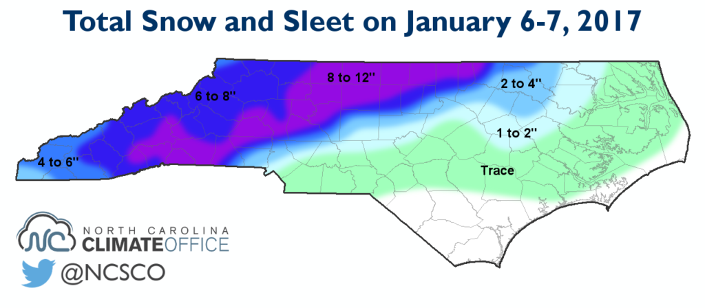
Substantial Snow in the Piedmont
As the event wrapped up on Saturday morning, the atmosphere again cooled back below freezing, allowing precipitation to end as snow in most areas. That was minor consolation prize in spots that saw mostly sleet or rain, yet were just 40 to 50 miles from some of the greatest snow totals.
Those highest totals came across the Triad and in the southern Foothills. Areas around Greensboro and Winston-Salem all reported more than 10 inches of snow, including 11 inches in Oak Ridge, Rural Hall, and Welcome. Farther south, parts of Lincoln, Caldwell, Cleveland, and Polk counties also reported 10 or more inches of snow.
At the Greensboro airport, which reported 8 inches of snow, it was the heaviest snowfall since a 9-inch accumulation in February 2014 and only the fourth time since 1996 with at least 8 inches in a single event. That 1996 event bore some striking similarities to the recent one. Along with falling over the same dates in early January, both events saw parts of the Piedmont receive 6 or more inches of snow with precipitation transitioning to sleet and rain farther east, substantially decreasing the snow totals.
Cold Rushes In
After the storm moved out, clearing skies, light winds, and a snowpack in place provided ideal conditions for some frigid nighttime temperatures. On Sunday morning, temperatures across the Piedmont dropped as low as -2°F at our ECONet station in Salisbury, which had 7 inches of snow on the ground.
Monday morning was a cold one as well, with all but the immediate coastline falling into the teens or single digits. The coolest spots again were where snow remained on the ground since it radiates heat back out to space much more effectively than bare ground.
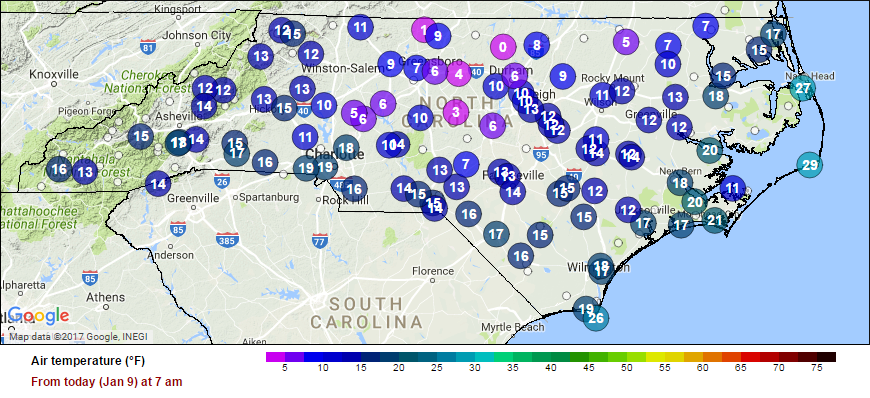
Low temperatures again hit the negative single digits in one part of the Piedmont, dropping down to -0.9°F in Yanceyville. Elsewhere, Roxboro hit a low of 0°F with Burlington falling to 3°F. Other rural areas hit the low single digits for the first time in nearly two years, having last dropped that low on February 20, 2015.
This round of cold and snow won’t stick around for long, though. Above-normal temperatures in the upper 60s are set to arrive later this week. It’s part of the variable pattern we discussed in our December climate summary, and we expect it continue as the winter rolls on.